What's the weather like in your area? Tweet us at @rapplerdotcom.
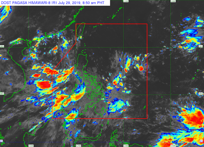
MANILA, Philippines – The state weather bureau is monitoring a low pressure area (LPA) that formed over the West Philippine Sea.
In a Facebook Live video at 5 am on Monday, July 29, the Philippine Atmospheric, Geophysical, and Astronomical Services Administration (PAGASA) said the LPA is 380 kilometers west of Dagupan City, Pangasinan.
According to PAGASA Weather Specialist Ariel Rojas, the LPA is likely to develop into a tropical depression, but it will most probably head for China and Vietnam instead of the Philippines.
The LPA, however, is enhancing the southwest monsoon or hanging habagat, which is affecting the entire country.
Below is the expected rainfall from the southwest monsoon on Monday.
Monsoon rain
- Mimaropa
- Cavite
- Batangas
- Bataan
- Zambales
Isolated rainshowers and thunderstorms
- Metro Manila
- Ilocos Region
- Cordillera Administrative Region
- Bicol
- the rest of Central Luzon
- the rest of Calabarzon
- Visayas
- Mindanao
Flash floods and landslides are possible during periods of heavy rain or severe thunderstorms. (READ: FAST FACTS: Tropical cyclones, rainfall advisories)
Aside from the LPA, Rojas said PAGASA does not expect any other potential tropical cyclone to enter or develop within the Philippine Area of Responsibility in the next 24 to 48 hours.
So far, the Philippines has had 7 tropical cyclones in 2019. (READ: LIST: PAGASA's names for tropical cyclones in 2019)
The country gets an average of 20 tropical cyclones annually, but since 2019 is an El Niño year, only 14 to 18 tropical cyclones are expected.
Below is the estimated number of tropical cyclones from July to December:
- July - 2 or 3
- August - 2 to 4
- September - 2 to 4
- October - 2 or 3
- November - 1 or 2
- December - 0 or 1
PAGASA declared the start of the rainy season last June 14. – Rappler.com