Every day, during the monsoon season, Rakhi Kumari, 18, checks the water levels of the Yamuna river near her house in Delhi. Her family of five, which lives in jhuggis (huts) on the floodplains of the river, has entrusted her with this responsibility.
In early July, when the monsoon was already well under way, Rakhi took a 20-minute walk from her house to the riverside to check if the water level had crossed the danger mark. “The monsoon season is always alarming for us,” said Rakhi, who runs a vocational unit in the area and teaches children how to stitch clothes. “Every year, the floodwater inundates our houses. We have made marks on trees on the river bed. This helps us decide when to pick up our belongings and take them to an elevated area.”
The Yamuna floodplains span nearly 10,000 hectares of land. They are cleaved by the river, which flows for 52 kilometres across the National Capital Region (NCR). The silt deposited by the Yamuna, the longest tributary of the Ganga, sustains many khadars or urban agricultural settlements such as Rakhi’s. It enriches the soil and fosters crop production.
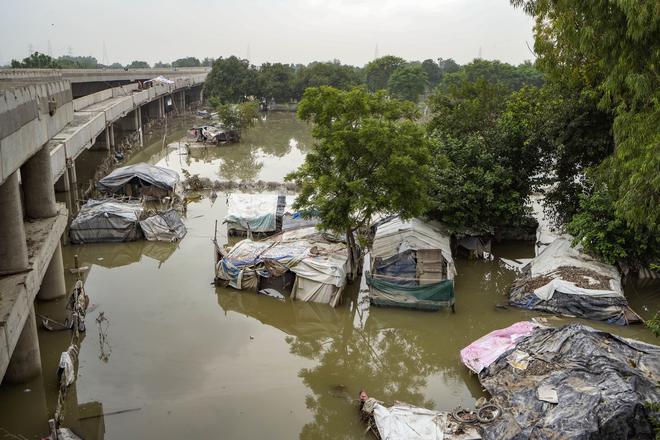
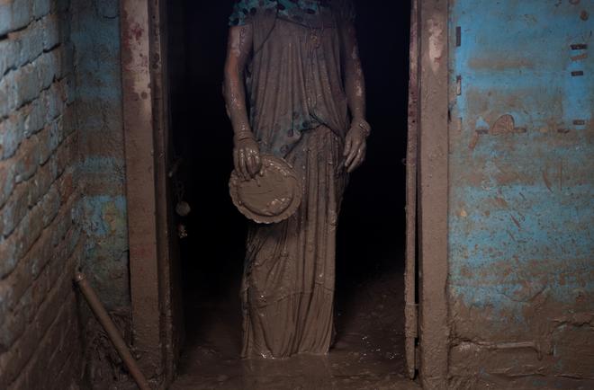
On that day, Rakhi saw the water level rise, but was relieved to find that it had not crossed the danger mark. However, on July 11, she and her neighbours began to panic as rains lashed the city and they found themselves in knee-deep water in just a few hours. Their jhuggis had never been so inundated in at least a decade. “When water is released from the Hathnikund barrage, it usually enters our homes and is ankle-deep. But this time, we found ourselves knee-deep in water. Soon, our houses were completely submerged,” Rakhi said while feeding her family’s only remaining buffalo.
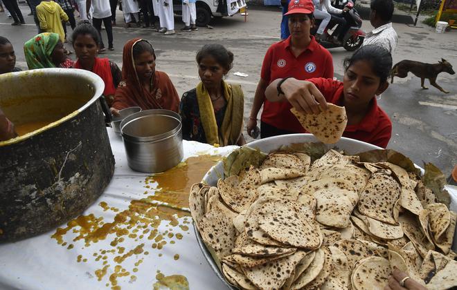
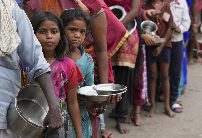
Two of the buffaloes had drowned and two were yet to be traced. Rakhi and her family were forced to move to a make-shift tent on a flyover near a metro station. The government has set up some tents on Pusta Road, while other tents have been put up by the residents of Yamuna Khadar.
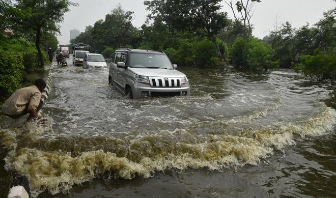
Delhi received the highest monsoon rainfall in 40 years in July. While the government established relief camps in various areas, not all flood-affected people have received relief, they said. In fact, several States in north India received record rainfall in July. According to the India Meteorological Department (IMD), north-west India experienced 59% excess rainfall than what is normal in the first fortnight of July. This occurred due to active monsoon conditions and a passing ‘Western Disturbance’ or an extratropical storm originating in Central Asia. The excess rainfall resulted in flooding, water-logging, and loss of property, leaving some regions paralysed for days.
Magnitude of floods
On July 10, with the IMD predicting heavy rainfall, the Delhi Police asked the residents of Yamuna Khadar, and those in other areas along the river bank, to move to safer places. But many stayed back, fearing loss of property and cattle.
Srinivas Saik, 35, was one of them. As his house flooded, he asked his wife and children to leave on a rescue boat on July 13. “Everyone knows that once you leave your jhuggi, you lose it,” he said. “And the Delhi Development Authority (DDA) anyway wants us to go.”
Srinivas took his buffaloes and moved to a nearby stretch on higher ground for four days. From there, he kept an eye on his jhuggi, which was fast disappearing under the rising muddy water. Soon, he realised that the ground on which he had sought refuge was also inundated. He was forced to move again.
Bereft of his possessions, Srinivas sat on a highway, mournfully staring at the plains that were once the source of his livelihood. “First the erratic rains partially destroyed our crops. Now, the floods have completely destroyed them. How are we supposed to make ends meet?” he said.
His neighbour, Rahul Kumar, rued that all the crops that got destroyed were on the verge of being harvested. “For the next 4-5 months, there will be no harvest and no earnings,” he said.
Srinivas and Rahul are among the many who have leased land on the floodplains for cultivation. However, despite the losses, they will have to pay rent, said Srinivas. “The owners will demand the lease instalments and will also take any compensation that comes from the government. We will not get anything,” lamented Rahul, a farmer in the Yamuna Khadar area whose father had migrated decades ago from Uttar Pradesh to work as an agricultural labourer.
The magnitude of the floods in Delhi is prompting khadar settlers to rethink their traditional practice of farming in the floodplains. “If floods of this magnitude keep happening, we will have to move back to our home towns or find work in another city,” said Rahul.
This, according to experts, is a high possibility. Torrential rains, and consequently floods, are expected to take place more often, they said. “The ongoing spell of extremely heavy rains is due to the alignment of three weather systems,” said Mahesh Palawat, vice president, Meteorology and Climate Change, Skymet Weather. “One, the Western Disturbance over the Western Himalayas. Two, the cyclonic circulation over the north-western plains. And three, the Axis of Monsoon trough running across Indo-Gangetic plains. This a giant belt of low pressure located in the east-west direction from north-west Rajasthan till the Bay of Bengal. Its movement influences the quantity of rainfall in monsoon.
“This alignment is not happening for the first time; it is the usual pattern during the monsoon. However, global warming-led changes in monsoon patterns have made a difference. There has been a constant rise in both land and sea temperatures, which has increased the capacity of the air to hold moisture for a longer time. Thus, the role of climate change in the increasing extreme weather events in India has been strengthening with each passing year,” he explained.
Encroachments on the floodplains
The journey of the Yamuna through Delhi is uneven. The width of the river can range from 800 metres to 3 km at various stretches. Experts have been saying for decades that the floodplains should be free of encroachments and large settlements, to aid the natural course of the river.
After the 1978 floods in Delhi, the biggest in the city before 2023, a Yamuna Standing Committee had recommended in 1979 that the “minimum spacing between future embankments on the banks of the river Yamuna be 5 km and the embankment aligned at a minimum distance of at least 600 m from the ‘active river edge’ at the time of construction of embankments.”
In 2014, another committee constituted by the National Green Tribunal (NGT) observed that “unfortunately” the decision had not been followed and the maximum distance between the two embankments of the river was less than 2 km. As a result, “the floodwater-carrying capacity of the river had been greatly compromised.” Delhi saw substantial floods in 2010 and 2013 and this, the committee warned, pointed to a “growing flood hazard”.
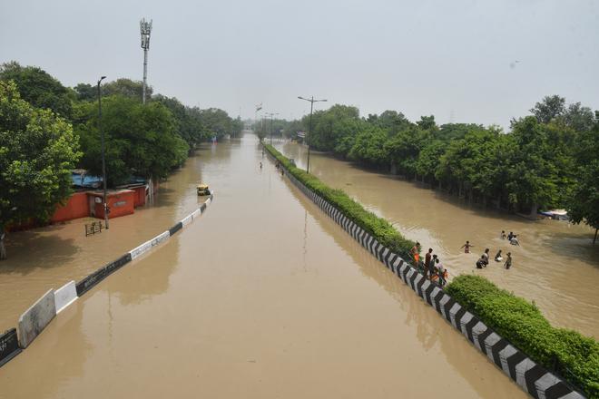
Nine years later, the Yamuna has flooded Delhi again. This time, the flood waters reached the highest-ever recorded level (208.66 m), inundating houses and arterial roads, and forcing thousands to move to relief camps.
“The current situation of the Yamuna floodplains is worse than 2014, when the report highlighted the issue. More illegal encroachments on the floodplains have left less space for the river to flow and for the water to percolate,” said A.K. Gosain, professor emeritus of the Department of Civil Engineering, Indian Institute of Technology (IIT) Delhi, and a member of a Principal Committee appointed by the NGT.
In 1987, a study by the Central Water and Power Research Station, Pune, warned that a reduction in the channel width, and construction of guide bunds on the floodplains, would increase the hazard of flooding on both sides of the river. In the years since, nearly 14 bridges have been constructed between the city’s Wazirabad and Okhla barrages. These contribute to the city’s flooding woes, said experts.
In 2015, in a landmark judgment in a case filed by Manoj Mishra, a former Indian Forest Service officer, the NGT formed the Maily Se Nirmal Yamuna Revitalization Plan, 2017, to clean the Yamuna and restore the floodplains by March 31, 2017. The judgment warned of “grave environmental disasters”. The NGT constituted a Principal Committee to identify all the existing structures in the floodplains and recommend which of them ought to be demolished.
Eight years later, official documents show that this is yet to be done. “Nobody is interested. The DDA knows that if these structures are identified, they will have to take further action and even demolish these encroachments,” Gosain said.
Apart from illegal encroachments, many official developmental works such as the Akshardham Temple, the Commonwealth Games Village, the Yamuna Bank Metro Station, and the Delhi Secretariat are built on the Yamuna floodplains.
The 2015 judgment had also directed the DDA, which is under the Central government, to physically demarcate the floodplains and prohibit construction activities in the demarcated region. “But when the Principal Committee visited the floodplains, it found that the demarcation was not done properly,” Gosain said.
As per the DDA’s Master Plan 2021, the floodplains are termed as ‘Zone O’. But in the Draft Master Plan 2041, the floodplains have been divided into Zone O-I and O-II. As per the plan, while no construction would be permitted in Zone O-I or the ‘river zone’ (6,295 ha), regulated development will be allowed in Zone O-II (3,638.36 ha).
“Why should they allow construction in the floodplains by terming it as Zone O-II? The 2015 judgment is clear that there cannot be any construction unless it is extremely important and that too done after careful scrutiny,” said Gosain.
A.K. Jain, former Commissioner (Planning) of the DDA, also said that allowing construction in Zone O-II would be dangerous. When asked why encroachments still happen in floodplains, he said, “There is political pressure and authorities are not autonomous. There is a nexus between politicians, bureaucrats, and the land mafia.”
Even the riverfront development project of the DDA includes pavements and permanent structures on the floodplains. “When we visited one of the river development sites, there were permanent constructions coming up on the riverfront. This will reduce the absorption capacity of the soil and reduce the area for the river to flow. And because of that, when the water level increases, the river will reclaim its natural flow area,” said Bhim Singh Rawat, associate coordinator, South Asia Networks on Dams, Rivers and People.
A political flashpoint
The release of water from Hathnikund barrage in Haryana, which is upstream of Delhi, became a political flashpoint between the Aam Aadmi Party, which is in power in Delhi, and the Bharatiya Janata Party, which governs Haryana. The water level of the Yamuna in Delhi depends heavily on the amount of water that is released from Hathnikund barrage.
After the Yamuna enters Delhi at Palla, it flows through Wazirabad to reach ITO, located at the heart of the city, before exiting from the Okhla barrage. The ITO barrage, though located in Delhi, is owned by the Haryana government. The Delhi government has alleged that five of the 32 gates of the barrage were “stuck,” which caused the flooding in parts of Delhi.
Representatives of the Haryana government said that the “required number of gates” were opened to their maximum limit for safe discharge of floodwater. Even the highest discharge passed smoothly without any hindrance, they said. Bhim Singh pointed out that though there are six flood monitoring stations between Hathnikund in Haryana and Old Railway Bridge in Delhi, the Yamuna waters breached the Highest Flood Level this time only in Delhi, which “showed” that the problem lay in Delhi.
An old drainage master plan
While the floodplain dwellers are used to moving into tents during the monsoon, those living in the residential parts of the city which abut the Yamuna were taken by surprise. Sandhya Raman, a resident of Civil Lines, said that in the past 30 years, she had never seen the area become so flooded. “When I looked from my first-floor balcony, I could see many cars ‘swimming’ in the main road,” she said. Her family of four moved to a relative’s place in Defence Colony for the next four days as electricity was cut off as a precautionary measure.
Even before the Yamuna flooded the city, there was heavy urban flooding earlier this month. Several stretches of the city could not be navigated. Currently, if there is about 100 mm of rainfall in 24 hours, even if the Yamuna flows at normal levels, the city goes under water. Due to urban flooding, in July 2020, a driver, 56, died in a waterlogged stretch under Minto Bridge in the heart of the city. Similarly, in July 2021, a 27-year-old drowned in a waterlogged underpass in Pul Prahladpur in south-east Delhi.
On June 10, Delhi Chief Minister Arvind Kejriwal said that Delhi’s system is not designed to handle “unprecedented” rainfall. At the core of this problem is the city’s drainage master plan, made in 1976, when the population of the city was only about 60 lakh. Since then, the population has increased about four times, but a new drainage master plan is yet to be finalised and implemented by the Delhi government.

In 2011, the Delhi government signed a Memorandum of Understanding with IIT Delhi for a Drainage Master Plan to find a solution to water-logging. Though IIT Delhi submitted the final draft to the Delhi government in 2018, a technical expert committee advised the Delhi government not to accept it. So, the government is now trying to get it done by private players and has floated tenders, but it has not made much headway.
Nishtha Gautam, a resident of Civil Lines, moved to a hotel when her area got flooded and electricity was disconnected. Aware of the possibility of the increasing frequency and magnitude of flooding in the area, Nishtha said that she was pondering a big decision. “Given Delhi’s air quality and its susceptibility to such calamities, I am thinking of moving back to my hometown near Mathura,” she said.
With inputs from Jacob Koshy