Damaging winds are sweeping from Australia’s west to east, with severe weather warnings in place for four states on Wednesday.
The Bureau of Meteorology is warning of “destructive” winds in Western Australia, South Australia, Victoria and New South Wales.
Dean Narramore, a meteorologist at the Bureau of Meteorology, said on Wednesday morning that the first in a series of fronts moved through South Australia and Victoria on Tuesday night, which brought damaging winds to Victoria and South Australia.
Narramore said a “second system is now moving through South Australia today, and will be impacting New South Wales and Victoria tomorrow with more heavy rain, damaging winds and blizzard conditions for some alpine areas”.
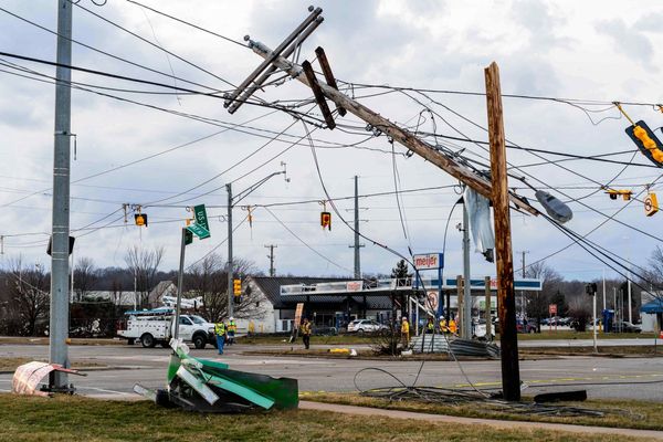
The wild weather caused power outages in Western Australia last night, including at Perth airport where flights were delayed or cancelled and passengers used the lights on their mobile phones to locate their luggage.
This is Perth Airport right now. Wild weather power outages quite literally leaving passengers in the dark, using their phone lights to try and find their luggage manually being brought out because the baggage carousels aren’t working. Delay & cancellation galore @9NewsPerth pic.twitter.com/BsegT92NsQ
— Zarisha Bradley (@ZarishaBradley9) August 2, 2022
Sitting in the dark cold boarding gate at Perth Airport while starving. An international airport without sufficient back up power 👏🏽👏🏽👏🏽 pic.twitter.com/95ye5ijHA5
— Simitha Singam - சிமித்தா சிங்கம் (@tsimitha) August 2, 2022
Passengers complained on social media of being left in the dark, cold and hungry.
Narramore said winds in Victoria also caused a power outage in Melbourne on Tuesday night affecting more than 10,000 people.
He said the winds moving through Victoria were “damaging to near destructive,” gusting up to 128km/h at Mount Hotham, 120km/h in the Grampians and around 90km/h through parts of Melbourne.
Damaging surf has also caused erosion on south-west WA beaches, which have been hit with waves as high as 10 metres.
Strong westerly winds are whipping up heavy surf conditions with swells reaching 8m off Rottnest Island this morning. These winds will continue through until late Wednesday, with sea conditions not set to ease until Thursday.
— Bureau of Meteorology, Western Australia (@BOM_WA) August 2, 2022
📷 Watermans Bay looking south towards North Beach. pic.twitter.com/4vLzYslOn8
⚠️💨DAMAGING WINDS averaging 65 km/h, peak gusts up to 110 km/h are occurring over elevated areas of the eastern ranges.
— Bureau of Meteorology, Victoria (@BOM_Vic) August 2, 2022
DAMAGING WINDS are expected to re-develop about the SW during Wednesday evening (averaging 50-60 km/h, peak gusts ~90 km/h)
Details: https://t.co/MvgCsfQfoM pic.twitter.com/R7dCfHnlIQ
In South Australia, the strongest winds are expected at Cape Willoughby, Neptune Island, Cleve and Ceduna.
In NSW, a severe weather warning for damaging winds and heavy rainfall was issued on Wednesday morning for parts of the Illawarra, South Coast, Southern Tablelands, South-West Slopes and Snowy Mountains, as well as the Australian Capital Territory.
David Karoly, a professor in geography, earth and atmospheric sciences at the University of Melbourne said the strong winds were important but “not that unusual”, and were caused by strong pressure gradients.
Narramore said the cause of the wild conditions was “a very large and complex” low pressure system south of Australia, and the multiple strong cold fronts moving with it.
He said later Wednesday and over the coming days “we expect the cold front to continue moving through south-eastern parts of the country with another burst of wind and rain”.
The rains will increase for north-eastern Victoria and south-eastern NSW, particularly around the ACT, Snowy Mountains and the alpine areas of Victoria, which could see heavy rain of up to a 100 millimetres on Thursday.
Narromore said the widespread rain could lead to minor to moderate flooding for inland NSW, where the worst effects will be inland west of Canberra, throughout alpine areas, Snowy Mountains and west facing slopes of the ranges in NSW.
He said the recently flooded coastal NSW communities will only see light falls.
Over the next 4 days parts of #NSW could see significant rainfall, including the chance of damaging #winds. A #SevereWeatherWarning and #FloodWatch is current. People are advised to monitor BoM warnings and check their local forecast.
— Bureau of Meteorology, New South Wales (@BOM_NSW) August 2, 2022
Warning & Forecasts: https://t.co/SPHgGeisGZ pic.twitter.com/xnwy7ahqF0
Flood watches are current for north-east Victoria and parts of south-east NSW in anticipation of the heavy rainfall that could lead to minor to moderate flooding.