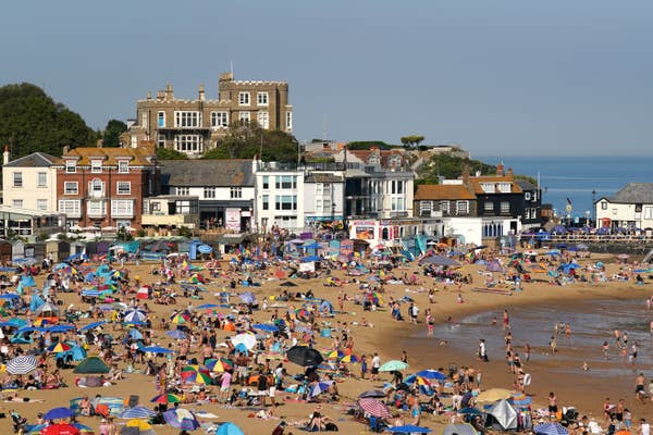
The UK is set to be hotter than the Costa Del Sol, with temperatures of up to 18C forecast.
The Met Office expects Thursday to be the hottest day of the year so far, with temperatures set to remain higher than average through much of the weekend in parts of England.
With parts of eastern England reaching up to 18C on Thursday, Met Office spokesperson Stephen Dixon said this was “obviously above average” and “fairly unusual but not unheard of” for early March.
While this is well above the average UK daytime maximum temperature in March of 9.2C, the highest March temperature on record was a reading of 25.6C on 29 March 1968.
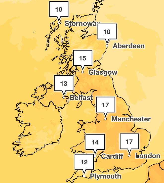
As a result of warm air drawing in from the southwest, the Met Office has predicted that London and Manchester will see highs of 16C.
Meanwhile, Barcelona is forecast to have highs of 14C and the Spanish Costa Del Sol highs of 12C. Elsewhere in Europe, holidaymakers in Malaga and Lisbon will be disappointed with temperatures only reaching 13C, significantly cooler than parts of the UK.
Forecasting “the warmest weekend that we’ve had for some time”, Mr Dixon predicted that we will see “good sunny spells on Saturday which should feel pleasant in the sunshine for many”.
This will be followed by sunny spells on Sunday with “some cloud and a chance of rain but generally a dry and fine day for much of the UK”.

But Mr Dixon said: “The thing to note is that it's not universally nice weather for everyone. So, there's patchy rain around on Friday, particularly for Western areas of Wales and South West and North West England, that comes with a bit more cloud as well.
“It's not necessarily shorts and head to the beach weather for the whole of the UK.”
But the UK has not seen the back of winter just yet, as the Met Office has predicted that temperatures will cool and could even bring flurries of snow over higher ground in Scotland as we move into next week.
This is due to a colder pool of air moving in from the northwest on Monday, going into Tuesday.
The Met Office said this was not unusual. “As we move through spring, we do get periods of warmer weather, and we also see colder plunges of weather, and that’s the current outlook in terms of temperature for the most for the UK,” Mr Dixon advised.
It follows a series of news reports claiming that a breakdown in the polar vortex – powerful winds that circulate in winter 30 miles above the Arctic – could lead to more snow later in the month.

But Mr Dixon stressed that, although there is a higher than normal risk of a cold snap in late March due to a breakdown in the vortex – known as a “sudden stratospheric warming” – there is certainly no guarantee of snow.
He told The Independent: “The stratosphere polar vortex is now weakening rapidly. Over the last few days, the forecasts have become very confident and we are almost certain there will be a sudden stratospheric warming (SSW) in mid-March. This is when the mid stratospheric wind is predicted to reverse from westerly to easterly.
“About 70 per cent of sudden stratospheric warming events are followed by a change to cold conditions with easterly winds across northern Europe and the UK. There are now signs of this in the forecast and the risk of a cold snap later in March is higher than normal.
“It is important to note that not all SSW events are followed by severe weather and more details on the intensity of surface weather effects from this event will be available in our weather forecasts.”