
The UK is being hit by powerful winds and downpours as the Met Office issues multiple weather warnings, including a fresh amber alert for rain and flooding posing a “danger to life”.
The “severe weather” is expected to sweep across the country on Sunday, bringing winds of up to 70mph, possible travel chaos, power cuts and flooding, warned the forecaster.
An amber alert was issued in south Wales – covering an area stretching from Camarthen to Newport, between 3pm on Sunday and 6am on Monday – with forecasters warning that up to 70mm of rain is expected widely, with 100mm possible in some areas.
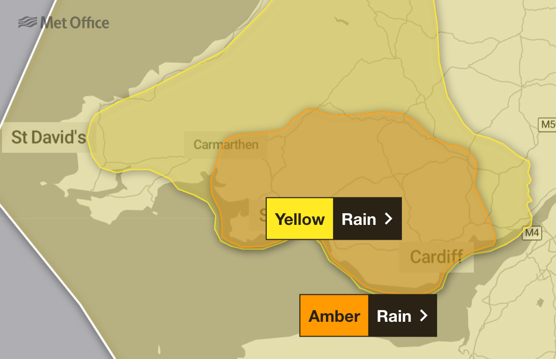
Homes and businesses are likely to be flooded, causing damage to some buildings, and communities could become cut off the Met Office said, warning that “fast flowing or deep floodwater is likely, causing danger to life”.
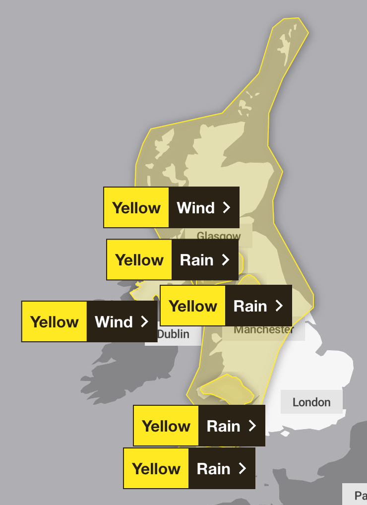
A separate yellow weather warning for rain came into force in the early hours of Sunday for parts of England, Scotland, and Wales, while the south-west of England was expected to be hit by showers from midday the same day.
A yellow alert for wind also came into force between 3am and 6am for Northern Ireland, while a second warning covering much of Britain came into effect three hours later and was set to last until 6pm, with the Met Office warning of “very strong winds” of up to 70mph.
The severe weather is expected to ease on Sunday night, with conditions to then improve in the following days next week.
Zoe Hutin, a meteorologist at the Met Office, said: “Certainly tomorrow [Sunday] looks to be the worst day in the coming few days.
“Today [Saturday] has been decent across the country, but from around 3am tomorrow morning for Northern Ireland, and 6am for mainland UK, we’ve got quite severe weather coming in from the west, very strong winds.
“We’ve got two wind warnings in force for that, and also heavy rain, leading to some rain warnings for the South West, south Wales, and also parts of the far north-west of England and south-west Scotland.
“The wind warning itself for the mainland UK ends at 6pm, but we can expect to continue to see quite blustery conditions even into the evening as the mainland rain itself pushes through.”
Late Sunday morning to early afternoon, gusts of 50 to 60mph are expected, and perhaps as much as 70mph in exposed spots along Irish Sea coastlines, Scottish Islands, and other areas of high ground further inland, said the Met Office.
Rainfall totals will be build through Sunday, particularly for some areas in the west - where weather warnings are in place ⚠️
— Met Office (@metoffice) February 22, 2025
Latest info 👉 https://t.co/QwDLMfRBfs pic.twitter.com/Yej1RSKpDL
The heaviest rain was expected to fall in parts of south-west Scotland and north England, whereas in the South West, up to 90 millimetres of rain may fall in some places, Ms Hutin added.
“But those rain warnings will end by midnight Sunday into Monday and thereafter, it does seem to be an improving picture,” Ms Hutin said.
“So while winds will stay quite blustery for a time into Sunday evening, actually they will be gradually easing.
“By the time people get up on Monday, we’ll still have some of the residual rain from that front in the far south-east of the country, and quite cloudy across England as well.
“But actually elsewhere, it could be a decent start.”
Though the weather will likely remain quite damp throughout Monday, with some hill fog in places, sunshine is expected to reappear gradually.
“In between those showers, though, it’s looking fairly good: we could see some good spells of sunshine,” Ms Hutin said.
Temperatures from Monday are also expected to remain mild and above average, with the south of England likely to see temperatures of up to 13C and close to 10C in Scotland and the north of England.
“But then through the week, those temperatures are trending back down,” Ms Hutin added.
“And so it will be getting cooler each day, but they will actually just be recovering to around average for the time of year. So it won’t be cold. It will just be returning back to where we would expect to be for this time of February.”