Looks like we’re in for a proper wintry blast next month, with the latest weather maps suggesting snow could fall across parts of the UK for three days straight. Some areas might even see up to 10 inches settle, making it one of the most significant cold snaps of the season.
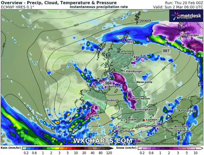
According to advanced weather modelling from ECMWF, the first flurries are expected to hit in the early hours of March 2. Northern Ireland, western Scotland, the northwest of England, and the West Midlands are all in the firing line. Greater Manchester could be in for a real dumping, with snow falling at an incredible rate of 10cm per hour around 6 a.m. Meanwhile, the Lake District might see 5cm per hour, making for some dramatic scenes.
As the day goes on, the snow is expected to sweep southeast, gradually weakening as it reaches East Anglia and London. But that’s not the end of it—March 3 is set to bring even more snow, mainly to Scotland and northern England. Some areas could see flurries of up to 2cm per hour by early evening.
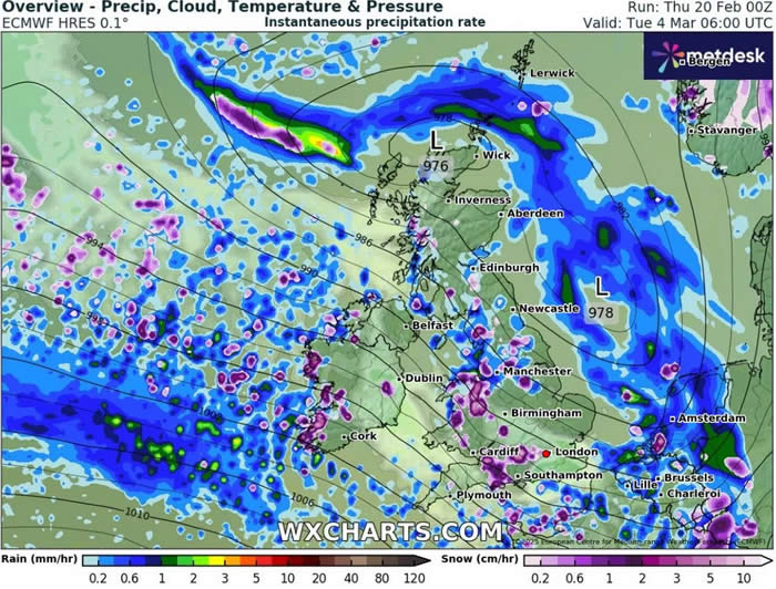
March 4 is where things could get even more intense, with heavier bursts of snow expected in parts of the north-west, North Wales, and even some areas of central southern England. Some places could be hit with another 10cm per hour during the morning. By the evening, a few lingering snow showers might still be hanging around in Wales and northern Scotland, but the main blizzards should have cleared by March 5.
Looking at snow depth predictions for March 4, northern Scotland could be buried under as much as 25cm (10 inches) of the white stuff by midday, while the Pennines might see around 8cm (3 inches). Even parts of southern England could get a dusting, with up to 1cm possible.
The Met Office is also keeping an eye on the situation, saying there’s definitely a “risk of snow” in the coming days. Their forecast for February 25 to March 6 notes that while the details are still uncertain, a mainly westerly weather pattern is expected to dominate. That means spells of mild, wet, and windy weather, mixed with colder snaps that could bring some snow—especially in the north and over higher ground.
There’s also a possibility of drier and more settled conditions in the south and southeast, but temperatures overall are likely to hover around or just above average. That said, don’t be surprised if we see some overnight frosts, particularly between weather fronts or during calmer spells.
So, if you were hoping for one last blast of winter, you might get your wish! It’s time to dig out the scarves and gloves—March could be bringing some proper snow days.