Alfred reaches mainland Queensland
The Bureau of Meteorology says the centre of Ex-Tropical Cyclone Alfred reached mainland Queensland above Brisbane around 9pm local time. The Bom says the tropical low is now expected to move inland more rapidly overnight tonight while weakening.
The Bom is still warning that damaging wind gusts are occurring about Moreton Bay and extending into some northern Brisbane suburbs due to a southeasterly wind surge interacting with the ex-tropical cyclone.
It says “heavy rainfall is likely to continue over southeast Queensland and northeast New South Wales during the weekend”.
Updated
Closing summary
That’s it from me, Hamish Mackay, and my Guardian colleagues for the evening. We’re pausing our live coverage. Thanks for reading.
Here is a summary of what we know so far about ex-Tropical Cyclone Alfred:
The centre of Ex-Tropical Cyclone Alfred made landfall around 8pm local time over Bribie Island, and moved west onto the mainland around 9pm, according to the BoM’s latest update. The bureau says the storm is expected to move inland more rapidly overnight while weakening.
More than 350,000 properties are without power across Queensland and NSW as ex-Tropical Cyclone Alfred hit eastern Australia.
Energex has indicated that full power restoration may take more than a week for south-east Queensland, where about 321,600 properties remain without power.
In northern NSW, roughly 31,000 are impacted by power outages.
Emergency services have been responding to a collision between two army trucks near Lismore. Some 36 people were involved, 13 of whom were injured.
Government minister Matt Keogh said he could not provide further details on the injured as it was an “evolving situation”.
Heavy rainfall is set to continue across south-east Queensland and northern NSW during the weekend. Both regions are on high alert for flooding, particularly at Lismore.
In NSW, dozens of emergency warnings remain in place, with thousands under evacuation notices. Only one emergency warning remains in place for Queensland.
The body of a man has been found in NSW, believed to be that of a 61-year-old who was swept into flood waters near Dorrigo yesterday afternoon.
To those in the impacted areas, please take care and look after yourself, and those around you.
Updated
Labor clinches victory to govern for third term in Western Australia
Away from the cyclone, Labor will govern for a third term in Western Australia, with the Liberal Party failing to attract the swing required to threaten Roger Cook’s majority.
Polls predicted a 12-13 per cent swing could put up to 11 seats in reach of the Liberal Party.
AAP reports that, with eight per cent of the vote counted, Labor had held the crucial seats of South Perth, Bateman and Scarborough, falling well short of the 30 seats it needed to win government.
ABC election analyst Antony Green said there was nothing to indicate anything other than the Labor Party being re-elected.
“The current lead they have in terms of votes being narrowed, but it is clear the government has been re-elected.
“The Labor Party will be re-elected, that is what I will say.”
13 of 36 involved in Lismore crash injured
We reported earlier that 36 people were involved in a road accident involving Australian Defence Force vehicles at Lismore, in northern New South Wales.
Initial reports suggested the majority of those involved had sustained injuries, but that has now been clarified.
Of the 36 Brisbane-based military personnel involved in the incident, 13 were injured, Australian government minister Matt Keogh said.
Keogh provided no details on what had happened or the injuries, but told Sky News:
These were people that were sent down to Lismore to assist those that are being impacted by floods and the effect of the cyclone there. And we thank all of the personnel, our Defence Force personnel, emergency services and others that are providing that assistance.
The 13 have been injured. I can’t give an update on the nature of those injuries, as you’ll appreciate. It’s an evolving situation. They’re being cared for at the moment and being provided assistance in various establishments to do that.
And we’re providing updates and support to their family members as well. And we’ll provide further updates tomorrow as we’re able to do that.
Updated
Downing Street issues statement on Albanese call
We reported earlier on the PM’s phone call with UK counterpart Keir Starmer. Downing Street has now issued this statement:
The Prime Minister spoke to the Prime Minister of Australia Anthony Albanese this morning.
The Prime Minister began by expressing his support for all Australians effected by the Cyclone and paid tribute to the strength of the partnership between the two countries.
The leaders agreed to stay in touch.
Jump in number of people in NSW and Queensland without power
According to Energex, some 293,780 homes and businesses in Queensland are now without power due to Alfred.
In NSW the latest figure is 31,000, meaning more than 324,000 properties are without power across both states.
New evacuation order issued in NSW
The New South Wales State Emergency Service has issued an evacuation order for areas impacted by flooding.
People rural areas along Yellow Rock Road and properties along Mylestom Drive should leave now before evacuation routes become blocked, NSW SES said.
It added:
Based on the predictions from the Bureau of Meteorology, rainfall associated with Ex. Tropical Cyclone Alfred may cause rapid river rises and extensive flooding.
Heavy and locally intense rainfall is continuing into the weekend over Northern NSW. Flash flooding is possible.This event may change quickly. NSW SES will monitor the situation and update warnings if the situation changes.
For more information on what you need to do, click here.
Updated
Ex-Tropical Cyclone Alfred – in pictures
Here are some of the latest images we’ve been sent by news agency photographers:
Updated
UK prime minister offers sympathy in call with Albanese
Anthony Albanese says he has spoken with his UK counterpart, Keir Starmer, this evening. The pair spoke about AUKUS, Ukraine and the cyclone.
On X, the prime minister posted:
Thank you for your sympathy for the impact of Cyclone Alfred.
Heavy rainfall is now the ‘real threat’, officials say
While the worst of the destructive winds may have been avoided, Bureau of Meteorology manager Matt Collopy has warned Alfred is likely to track west across the Australian mainland in the coming days, bringing heavy rain.
Collopy told reporters:
The real threat now is from that locally heavy-to-intense rainfall, which may lead to flash and riverine flooding.
Ex-Tropical Cyclone Alfred: what we know so far
Many thanks for joining me on the blog this evening. I’ll be handing the reins over to Hamish Mackay, who will continue to bring you the latest into the night.
Here is where the ex-Tropical Cyclone Alfred situation is now at:
The tropical low is slowly approaching the coast at Bribie Island, with a crossing expected “in the next hour or two”.
The Bureau of Meteorology expects it to move west and cross the Queensland mainland between Maroochydore and Caboolture this evening.
Emergency services have been responding to a collision between two army trucks near Lismore, where 36 have been reported as injured.
Heavy rainfall is set to continue across south-east Queensland and northern NSW during the weekend. Both regions are on high alert for flooding, particularly at Lismore.
In NSW, dozens of emergency warnings remain in place, with thousands under evacuation notices. Only one emergency warning remains in place for Queensland.
Energex has indicated that full power restoration may take more than a week for south-east Queensland, where about 262,000 properties remain without power.
In northern NSW, roughly 31,000 are impacted by power outages.
The body of a man has been found in NSW, believed to be that of a 61-year-old who was swept into flood waters near Dorrigo yesterday afternoon.
To those in the impacted areas, please take care and look after yourself, and those around you.
Updated
Ex-TC Alfred expected to cross Bribie Island coast in 'next hour or two'
The Bureau of Meteorology has released an updated tracking map for ex-Tropical Cyclone Alfred.
It says the system is slowly approaching the coast at Bribie Island, “with a crossing expected in the next hour or two”.
The system is now located 60km north-east of Brisbane and 45km south-east of Maroochydore, and is slow moving.
Heavy rainfall is forecast to continue over south-east Queensland and north-east NSW through the weekend as ex-TC Alfred crosses the mainland coast “this evening and moves slowly inland”.
The system crossed Moreton Island as a category one system just after midnight this morning, and weakened to a tropical low at 6am.
Updated
About 286,000 without power across NSW and Queensland
Let’s check in on the power outages across south-east Queensland and northern NSW.
According to Energex, 255,590 properties remained without power in south-east Queensland. The most impacted LGA was the Gold Coast, which accounted for 131,967 of the outages.
In NSW, about 31,000 properties from Tweeds Heads through to Grafton were without power, according to Essential Energy.
This means across both states about 286,000 remained in the dark.
Updated
PM and emergency minister express condolences after man dies in NSW floods
The prime minister, Anthony Albanese, has sent his condolences to the family of a 61-year-old man who died in flood waters near Dorrigo, in northern NSW.
Tragic news out of New South Wales this evening with confirmation a man has died in floodwaters near Dorrigo. Our thoughts are with his loved ones and the community at this heartbreaking time.
The emergency management minister, Jenny McAllister, has also issued a statement after the news:
Deeply saddened to hear that authorities have confirmed a man has died in floodwaters near Dorrigo. Our thoughts are with his loved ones and his community.
Updated
Dutton sends ‘thoughts, prayers and gratitude’ to injured defence personnel
Peter Dutton says he is “deeply concerned” by reports that defence personnel have been seriously injured in a crash while assisting with flood recovery near Lismore.
In a post to social media, the opposition leader wrote:
The ADF is at the forefront of Australia’s disaster response, bravely stepping into danger to protect and support communities.
Our thoughts, prayers and gratitude are with them, their families, and their fellow personnel. Wishing all those injured a full and speedy recovery.
Defence confirms a number of personnel providing support in Lismore injured in crash
The Australian defence force has issued a statement on the crash involving two of its vehicles near Lismore this afternoon.
It confirmed that a number of personnel who were providing community support in Lismore amid ex-TC Alfred were injured in the collision.
The welfare of ADF members and their families is a priority and defence’s focus is on supporting those involved.
Due to the developing nature of the incident, no further information will be available at this time, however defence will provide further updates when possible.
Updated
Injured ADF personnel taken to four hospitals, ambulance spokesperson says
We are continuing to monitor for updates on the crash involving two army trucks just outside Lismore after 5pm this afternoon.
To recap: NSW ambulance says 36 people were injured. The spokesperson could not confirm the nature of any injuries, or how many people were taken to hospital.
But patients had been transported to Lismore, Byron, Ballina and Tweed Valley hospitals, the spokesperson said.
The prime minister, Anthony Albanese, said earlier this was an ongoing incident and some personnel had been “seriously” injured.
NSW police earlier confirmed the crash involved two ADF trucks. Officers from the crash investigation unit were investigating the circumstances, and members of the public were urged to avoid the area.
ADF personnel had been deployed to the Lismore region to support the ex-Tropical Cyclone Alfred response and recovery efforts.
Updated
Lismore MP expresses ‘heartfelt concern’ for injured defence personnel
The NSW MP for Lismore, Janelle Saffin, has extended her heartfelt concern for the injured ADF personnel.
In a post to social media just a few minutes ago, she wrote:
To the Australian defence force soldiers, their families, and their Australian defence force family, our community expresses its heartfelt concern and send our love to those personnel injured and their families.
They came in service to our Northern Rivers communities in our time of need and we stand ready to help in their time of need.
Updated
Strong winds tear roof off home in Ballina
The NSW SES has shared a video from Ballina, where the strong winds tore the roof off a local resident’s home:
Facing gale-force winds today, NSW SES Ballina Unit was on the ground responding to the aftermath of Ex Cyclone Alfred and significant weather resulting in storm, flood, and tree damage. These powerful winds tore the roof off this Ballina resident's home. 😲
— NSW SES (@NSWSES) March 8, 2025
📞Need help? 132 500 pic.twitter.com/XPhmWHKQk3
PM says some ADF personnel 'seriously' injured in crash
The prime minister, Anthony Albanese, and the deputy PM, Richard Marles, have released a joint statement on the crash near Lismore involving two army trucks which has left 36 injured.
The pair said a number of ADF personnel had been injured, “some seriously”.
Medical assistance is on hand. We stress this is an ongoing incident.
Right now our focus is on the welfare of those involved and their families. Our ADF heroes were on their way to help Australians in need.
Updated
It’s too early to say ex-TC Alfred is a ‘fizzer’, Watt says
Labor senator Murray Watt has shared a video update on ex-TC Alfred, urging people to remain vigilant for heavy rain and flooding, and to take the situation seriously.
Tropical Cyclone Alfred has been downgraded, but the risk of flooding is still present. Stay safe and be aware of the risks. pic.twitter.com/iOfJ94FBXI
— Senator Murray Watt (@MurrayWatt) March 8, 2025
Two ADF trucks collided in crash near Lismore, police confirm
NSW police have confirmed a number of ADF personnel have been injured after two ADF trucks were involved in a collision near Lismore.
Emergency services were called to Tregeagle Road, about 9km south of Lismore, just after 5pm amid reports two ADF trucks had collided.
Multiple emergency services responded, including paramedics and police officers.
Officers from the crash investigation unit would investigate the circumstances surrounding the crash, NSW police said in a statement.
Tregeagle Road is currently closed, and members of the public are urged to avoid the area … No further information is available at this time.
Updated
Minns ‘very concerned’ by reports of accident involving ADF personnel
The NSW premier, Chris Minns, says he is “very concerned” to hear reports of an accident involving ADF personnel.
They came to the Northern Rivers to help keep this community safe. NSW emergency services are currently responding on the scene and we will provide all support necessary.
Reports of trapped ADF personnel in crash at Lismore
The Sydney Morning Herald reports that its photographer Nick Moir was travelling from Coraki to Lismore when he encountered the accident, involving an Australian defence force vehicle.
Moir assisted in triage and first aid before ambulance, firefighters and police rescue arrived, the report states.
The Age reports the incident involved a large army troop transport, and that there were three trapped ADF personnel.
Updated
More than 30 injured in road accident involving defence vehicle at Lismore
Thirty-six people have been injured in a road accident at Lismore, in northern NSW, involving at least one Australian defence force vehicle.
NSW ambulance received a call at 5.05pm about the incident. Initial reports suggested there were 22 patients, but this was updated to 36 just minutes ago.
Nineteen ambulances were dispatched to Tregeagle Road. It was not yet known what type of ADF vehicle, or how many, were involved.
Patients were transported to both Lismore and Tweed hospitals.
Updated
Early evening update
As we move into the evening, here is where the ex-Tropical Cyclone Alfred situation is now at:
Ex-Tropical Cyclone Alfred is now sitting just off Bribie Island as a tropical low, expected to slowly move west and cross the mainland between Maroochydore and Caboolture this evening.
Heavy rainfall is set to continue across south-east Queensland and northern NSW during the weekend.
Both regions are on high alert for flooding, particularly at Lismore and through northern NSW.
In NSW, dozens of emergency warnings remain in place, with about 11,000 people under evacuation notices.
Only one emergency warning remains in place for Queensland.
Energex has indicated that full power restoration may take more than a week for south-east Queensland, where about 247,000 properties remain without power.
In northern NSW, roughly 31,000 are impacted by power outages.
The body of a man has been found in NSW, believed to be that of a 61-year-old who was swept into flood waters near Dorrigo yesterday afternoon.
Authorities across both NSW and Queensland have continued to stress that the worst is not over, and people in affected areas should continue monitoring conditions.
Updated
Body located during search for man missing in NSW flood waters
A body has been found amid a search for a man who was swept into NSW flood waters yesterday afternoon.
The man, 61, was lost in flood waters last night near Dorrigo in the north of the state, when a ute was washed off a bridge into fast-running water.
He had climbed out of the ute into a tree about 30 metres from the riverbank, but emergency services were unable to reach him before he was swept away.
NSW police have confirmed the body of a man was located nearby about 4.30pm this afternoon.
While the body is yet to be formally identified, it is believed to be that of the missing man. A report will be prepared for the coroner.
Updated
More photos of the damage and recovery effort
Here are some more photos that have been filtering through tonight, of the damage caused by ex-Tropical Cyclone Alfred and the recovery works that are under way.
Updated
Some East Bellingen residents urged to move to higher ground
The NSW SES has issued an emergency warning for East Bellingen, warning residents in the following locations to move to higher ground amid potential major flooding:
Old Butter Factory, Doepel Street
Mill Street
Cahill Street
Parts of Waterfall Way
The warning states that rising flood water is “making it unsafe to evacuate the area”.
You should immediately go inside a sturdy multi-storey building with access to upper levels, higher natural ground such as a hill, onto the roof of a sturdy building. Do not enter the roof cavity as you may become trapped. Move as high above ground as possible. You may now be trapped without power, water, and other essential services and it may be dangerous for NSW SES to rescue you.
Updated
Crisafulli says Queensland-NSW border doesn’t ‘separate our compassion for a fellow human’
Asked about the northern rivers of NSW, David Crisafulli says he has been speaking with the NSW premier, Chris Minns, every day.
While there is a border that separates our responsibility, it doesn’t separate our compassion for a fellow human … We will be there and we know that they will be there for us.
With that, the press conference wraps up.
Updated
Queensland premier says priority is re-establishing things that ‘make life normal’
David Crisafulli is now taking questions. He says his main priority right now is “to re-establish all of the things that make life normal again”.
Can we get power working? Can we get water running? Can we get roads [cleared]? That is our first priority, [as well as] making sure that as we repair things, we do it in a stronger way.
Updated
Energex representative provides update
A representative from Energex says more than 1,000 live power lines have been on the ground amid the ex-cyclone.
Please be careful, don’t assume that they are turned off.
He also reiterates a warning for those with generators, that they are dangerous if activated inside.
As we reported earlier, four people were taken to hospital with carbon monoxide poisoning, but they are OK. The representative says:
There has been an event on the Gold Coast where people were lucky, [it] could have ended in tragedy, so don’t operate them inside, please.
Updated
Police to doorknock emergency alerts in areas without power if needed
Shane Chelepy says his focus is now on critical infrastructure, and working to ensure communications and power get back up and running.
We are currently assessing our communities that have those limited communications and I can assure you that, if needed, emergency services will undertake doorknocking in those areas, should we have emergency messages to be delivered.
Updated
Only one emergency warning remaining in Queensland
The acting police commissioner, Shane Chelepy, is also providing an update, and says there has been no loss of life or missing persons in Queensland amid the ex-cyclone.
He says only one emergency warning remains in place, for people at Killarney to conserve water amid supply issues.
All other emergency alerts that have been issued have now been cancelled and we will continue to message the community as needed.
Updated
Flooding the main concern in coming days as ex-TC Alfred moves west
The representative says as the remnants of ex-TC Alfred move inland, an infeed of tropical moisture will drive “heavy to intense rainfall”.
We are expecting widespread totals of 300 to 500mm, and event totals of up to 700mm are possible up to Monday. The current radar images show bands of heavy rain wrapping around the southern and eastern flank of ex-Tropical Cyclone Alfred. It is these areas of heavy to intense rainfall that are of most concern over the next 24-48 hours, as the system tracks west.
Localised falls of 100-200mm are possible during six-hour periods and these could lead to life-threatening flash flooding. In terms of the broader or more widespread rainfall totals of 300-500mm over multiple days, this is a concern for riverine flooding.
Updated
No longer a risk of a significant storm surge
A representative from the Bureau of Meteorology says ex-TC Alfred remains near Bribie Island and is “quite slow-moving”.
The wind will ease as we move through this evening … We are expecting ongoing coastal erosion. There is no longer a risk of a significant storm surge and sea levels are not expected to exceed the normal highest astronomical tide.
Updated
Premier most worried about impacts of rainfall
David Crisafulli says in the last hour, a 95km/h wind gust was recorded at the Gold Coast, as well as readings of 70km/h at Moreton Island.
It’s rainfall that worries us.
He wraps up by saying people would “overwhelmingly” do the right thing if given the right amount of information:
If you are on the Gold Coast, getting around is going to be a little more difficult than if you are on the Sunshine Coast, but you will make the right decision if you drive to the conditions.
Updated
Government aiming for as many schools as possible to reopen on Monday
David Crisafulli says the government intends to “bring as many schools back online for Monday” as possible.
We will update you tomorrow about that.
Updated
Half of Gold Coast’s traffic lights offline
David Crisafulli says around half the traffic lights in the Gold Coast remain offline.
Around 16% remain offline in Brisbane and 3% on the Sunshine Coast.
It’s an epic task, already 100 roads have been cleared [and there is] more work to be done, but good work today.
Updated
Buses to operate from tomorrow but not trains
The Queensland premier says a normal bus timetable will operate for Brisbane tomorrow.
In Moreton Bay the Sunday timetable will operate as normal, aside from on Brisbie Island … On the Sunshine Coast the timetable will be running. In Ipswich and Toowoomba the timetable will be running. In Logan and Caboolture there will be partial services.
But rail services will not return tomorrow, David Crisafulli says.
There’s a lot of assessment work to be done, to be cleared on the track. The Gold Coast line needs to be assessed and we will update Queenslanders tomorrow.
Updated
More supermarkets to reopen from tomorrow
David Crisafulli says some supermarkets are beginning to reopen today, and “many more” will reopen tomorrow.
We are delighted by that, on a case-by-case basis we asked them to share that information with Queenslanders, but we are most grateful for how quickly that is coming back online because people need that.
Service stations have begun reopening and again, on a case-by-case basis, there will be more.
Updated
Virtual emergency care to continue for next fortnight in Queensland
David Crisafulli says virtual emergency care is continuing, with 530 patients having accessed this since Thursday.
That will continue for the next fortnight to make sure people don’t miss quality care during the disaster.
Updated
Energex and Queensland government work with telcos to restore services
The Queensland SES has responded to 1,000 callouts today, David Crisafulli says, with about one-third of these for structural damage and falling trees.
In terms of telecommunications, the Queensland premier says a number of sites remain offline.
We have tasked Energex to work with those telcos and while it is not a responsibility of the state … we are doing all we can to help them get back up.
He says connections have been restored for seven government wireless network towers.
Updated
Some 30,000 power connections restored in 90 minutes in Queensland
Sticking with power, David Crisafulli says 30,000 connections have been restored in the last 90 minutes alone.
That’s 70,000 connections restored since Thursday night.
According to Energex, 266,562 properties across south-east Queensland remain without power.
Updated
Queensland premier provides ex-cyclone update
The Queensland premier, David Crisafulli, is providing an update on the ex-tropical cyclone.
He notes the four key elements of the weather event – winds, waves, rainfall and flooding – and says right now “we’re in the middle of those four things”.
On the power outages, he says since the start of ex-TC Alfred, 330,000 homes and businesses have gone without power.
If you think about that, that’s somewhere in the order of about three-quarters of a million Queenslanders who’ve been impacted. To put that into perspective, at 330,000, that’s the largest ever loss of power from a natural disaster in Queensland’s history.
He says in the last few minutes, power has been restored to the Gold Coast university hospital.
Updated
Flooding in Lismore – in photos
Some photos are filtering through from Lismore, showing the flooding impacts in town amid ex-Tropical Cyclone Alfred:
Updated
Queensland premier to provide ex-cyclone update this afternoon
We’re expecting the Queensland premier, David Crisafulli, to give a press conference in around 15 minutes’ time. We’ll bring you all the key updates from that right here on the blog.
Updated
Map of widespread flooding across east coast
The Bureau of Meteorology has published this map detailing the flooding across south-east Queensland and northern NSW, with heavy rainfall stretching from Brisbane to Port Macquarie.
Rivers are rising across much of south-east #Qld & north-east #NSW. Rain from ex-Tropical #CycloneAlfred has brought widespread rainfall from Brisbane to Port Macquarie. Major flood warnings are current across Qld & NSW. More: https://t.co/BoFbdY0OoU. pic.twitter.com/p8ESi2xhAn
— Bureau of Meteorology, Australia (@BOM_au) March 8, 2025
Updated
Just under 300,000 remain without power across both NSW and Queensland
Continuing from our last post: the latest information from Energex shows that 267,196 properties remained without power across south-east Queensland.
This means that about 298,000 properties across both NSW and Queensland remained impacted by power outages.
Updated
31,000 remain without power in northern NSW, Essential Energy says
Essential Energy says as of half an hour ago, 31,000 properties in northern NSW remained without power amid ex-TC Alfred.
Crews were able to make progress on restoration efforts today, it said, “thanks to a break in the weather”.
The power outages stretch from Tweeds Heads through to Grafton. Some 19,500 properties had power restored today, although “continued extreme weather has resulted in additional outages”.
Customers are encouraged to prepare to be without power for several days as the extreme weather conditions continue to make it unsafe for crews to work in and cause damage to the network.
When the weather clears, additional crews will be brought in to assist with the cleanup and repairs, however, access to locations prone to flooding or landslides will delay restoration in some of the hinterland or more remote areas of the region.
If flood waters impact communities, it will lengthen the time before power can be restored. Crews are unable to turn the power on safely if powerlines or areas of the network are in contact with water.
Updated
Man charged with allegedly threatening emergency service workers in NSW
A man has been charged for allegedly threatening emergency service workers at a sandbag station in northern NSW yesterday.
According to NSW police, SES workers and members of the public were filling sandbags at Corindi Beach about 2.30pm yesterday, when a man allegedly drove to the site and filled a number of sandbags, took them and drove away.
An hour later the man, 23, allegedly returned and took a number of sandbags from other members of the public.
An SES worker spoke with the man, who then allegedly threatened the worker while armed with a shovel, before threatening other workers and community members nearby.
The man was arrested and his vehicle searched, where police allegedly located and seized a knife and a machete. The shovel was also seized.
He was taken to Coffs Harbour police station and charged with intimidation with the intention of fear or physical harm, and having a knife in a public place.
He was refused bail and appeared at Parramatta bail court today, where a further charge of intimidating a frontline emergency worker was laid.
Updated
About 280 Tweed residents in evacuation centres
In terms of flooding in the Tweed region, Chris Cherry said flooding at Chinderah was expected to reach moderate levels tomorrow morning.
South Murwillumbah was expected to reach between moderate and major tonight, she said, “so it is going to be a very sleepless night here”.
About 260-280 people were in evacuation centres now, the mayor said, noting it was an “incredibly traumatising time”.
I don’t think anyone would go to an evacuation centre by choice. I think people are very stressed, you know, it’s confusing … The evacuation centres seem to be pretty well set up, and it seems to be running pretty smoothly, so we are incredibly grateful that there are six in our shire.
Updated
Half of Tweed residents without power, mayor says
Chris Cherry, the Tweed mayor, said half of the town’s residents were without power and “haven’t had it for a few days now”, and residents needed to boil their water.
Providing an update on ABC TV, she said trees were down “all over the whole shire” in northern NSW.
It’s a very difficult time and I think it will be a long night for us here in Tweed.
She said all residents were being asked to reserve water because the power outages were “cutting our ability to restock or refill our reservoirs”.
The water supplies are getting quite critical … We have a burst water main, it is not safe now. We are asking people to boil it.
The mayor said locals should prepare for multiple days without power:
There is a lot of areas that are out that will not be attended to straight away, and I think everyone needs to accept that they may not have power for another probably one or two days.
Updated
Ex-Tropical Cyclone Alfred damage – in pictures
Here are some photos that have been filtering through today, of the damage ex-Tropical Cyclone Alfred has already wreaked across south-east Queensland and northern NSW:
Updated
Number of people in south-east Queensland without power down slightly
The number of people without power in Queensland has come down slightly – but hundreds of thousands remain in the dark.
As of 3.15pm AEST, 275,931 were without power across south-east Queensland, according to Energex.
This is down from the 295,909 figure at midday.
Updated
Stay inside until given the all clear, NSW SES deputy commissioner says
Debbie Platz also said that “intermittent, unpredictable rain” was expected to continue for at least two days, urging people to remain inside until given the all clear.
This event is not over. We do expect that we are going to have at least probably two days of intermittent, unpredictable rain, which could be intense in some places, so please stay inside until we give you the all clear to go back to your communities.
36 flood rescues in NSW, mostly for people driving on roads
Debbie Platz said there had been 36 flood rescues – predominantly for people trying to drive on roadways “unnecessarily” into flood waters.
They are putting their own lives at risk and those of their families, but also those of our emergency services volunteers and officers.
In the last 24 hours there had been nearly 1,600 calls for help, she added – largely about fallen trees, leaking roofs and sandbagging.
But it is the 36 flood rescues that continue to concern us, that people [are] out and about unnecessarily on the roads.
Updated
NSW SES continually monitoring forecasts to try to reduce number of people required to evacuate
The deputy commissioner of the NSW SES, Debbie Platz, says authorities are trying to reduce the number of people required to evacuate where possible.
Providing an update on ABC TV, she said 126 warnings were in place and 34 of those remained at emergency level.
She said the SES was continually assessing the modelling and forecasting to “try to reduce the number of people that have to evacuate”.
We currently have about 11,000 people under the evacuation warnings, so we’re hoping we can reduce that – but it does [depend] on what is happening over the next 24 hours with the rainfall …
We have been slowly able to reduce them, and sometimes reducing them from potentially a whole town down to a smaller part of the town, particularly in low-lying areas.
Updated
Tropical low expected to move inland throughout today, ‘maybe into tomorrow morning’
In terms of when the tropical low will actually make landfall, the BoM’s Christie Johnson says it will “eventually” – but is “taking a long time”.
It should move inland for probably the rest of today, maybe into tomorrow morning, and then it will start to take a bit more of a south-westerly track and track down – perhaps reaching into northern NSW in the new week.
Updated
BoM provides update on status of ex-cyclone system
The senior meteorologist Christie Johnson from the Bureau of Meteorology says that ex-TC Alfred is “sitting out there” off the coast of Bribie Island, “churning away [and] sending very strong winds across south-east Queensland”.
Providing an update on Channel Nine, she said sustained gale-force winds were occurring along the Gold Coast, and the rainfall was expected to get heavier:
[We’re] expecting the rain to actually get heavier as we go through the rest of the afternoon and particularly into the evening and overnight, when Alfred finally gets his skates on and starts moving onshore.
Johnson said it had been a “slow system for the last couple of days” and once the tropical low moves on to land, it was expected to move slowly inland.
However, the fact that it’s taking so long to even get on land means it may be even slower than currently our forecasts are showing.
Updated
Power restored to 17,000 properties in NSW, Essential Energy says
Luke Jenner, the chief operating officer at Essential Energy, has provided an update on the power outages across northern NSW.
Speaking to Channel Nine, he said there were now about 36,000 homes and businesses without power. Some 250 field crews had been out today working to restore power, he said, and power had been restored to about 17,000 properties.
But unfortunately, there have been some additional outages through the course of the day because … this is an evolving event.
The worst impacted areas include Tweed Heads, Armidale and Ballina, “and then stretching down the coast to Grafton”, he said.
Jenner could not give a timeframe for a complete restoration of services, but said people should be prepared for “extended outages, especially in some of the hinterland areas where we still can’t get access due to flooding and road closure”.
There’s weather forecasts that say there’ll be upwards of 100mm of rain over the next three to five days. So all we can do at this stage is keep assessing the damage, working through it, bringing in additional resources, and we’ll absolutely make sure we keep the community up to date.
Updated
Littleproud warns potential flooding at Lockyer Valley could impact supply chains
The Nationals leader, David Littleproud, spoke to Sky News from Ryeford in Queensland earlier this afternoon, where the community was “watching and worried about how much rain [the ex-cyclone will] dump”.
He said the winds were “not to the extent that we were first worried about”, and the focus was now on potential flooding impacts in the region – particularly in the Lockyer Valley.
They’ve had three floods over the last three years, and … this would just decimate the Lockyer Valley again. But we’re hoping that if it is 50mm to 100mm, then we might get away with it … But this is a critical time, and obviously, if we see huge damage, then that will flow through the checkout eventually. If the supply goes down, then your price is going to go up.
People in the Lockyer Valley are prepared, they’re obviously used to this, but we are watching very closely and that’s one of the key areas. Obviously, we’re watching it go through Brisbane – that’s the next point of contact.
Updated
Qantas working to restart flights at Brisbane, Gold Coast and Maroochydore
Qantas says it is working to restart domestic and international flights at Brisbane, Gold Coast and Maroochydore from 6am tomorrow.
In a statement, the airline says this is “subject to weather conditions and safety assessments”.
We are expecting to progressively rebuild our schedule throughout the day.
Our teams are working to help customers travel in and out of southeast Queensland and northern NSW as safely and as quickly as possible and continue to work closely with the state and federal government and the relevant local airport authorities.
Updated
270 Optus mobile sites lose connection due to power failures
Optus says 270 of its mobile sites have lost connection due to power failures in northern NSW and south-east Queensland.
In its latest update, Optus said the outages were impacting mobile and NBN fixed services “for a large number of customers”.
Generators, SatCats and additional personnel are being moved to the most significant sites where safe to do so, with extreme weather conditions continuing in the area.
The safety and wellbeing of our customers and employees are of the utmost importance as we work as quickly as possible to restore services. At this stage, we don’t know how long it will take to resolve services, however we are prioritising our resources to address impacted areas and support connectivity at key evacuation centres.
The statement said customers may be able to use Optus wifi calling, or apps such as WhatsApp or FaceTime to make calls where wifi was enabled.
Updated
Mid-afternoon update
For those just joining us, here’s a recap of where the ex-Tropical Cyclone Alfred situation is now at:
Ex-Tropical Cyclone Alfred has “essentially stalled for the moment” off the coast of Bribie Island, the Bureau of Meteorology says. The tropical low is expected to move northwards for the rest of the afternoon, before making landfall.
All the emergency warnings in Queensland have been downgraded to “watch and act” level.
Energex has indicated that full power restoration may take more than a week for south-east Queensland.
Some 292,417 people in south-east Queensland remained without power, as of 2.15pm AEST. In northern NSW, just over 42,600 homes and businesses were without power as of 11am AEDT.
NSW police are continuing to search for a man lost in flood waters last night near Dorrigo after a ute was washed off a bridge into fast-running water. Efforts are being hampered by the intense weather.
Flooding at Lismore in northern NSW is no longer expected to reach the height of the CBD levee – although major flooding is possible.
Authorities across both NSW and Queensland have continued to stress that the worst is not over. The NSW premier, Chris Minns, said it was “crucially important that the public not dismiss this weather event as something that has already passed”.
Updated
Flooding at Lismore no longer expected to reach height of CBD levee
The latest flood warning out of Lismore says water levels are no longer expected to reach the height of the Lismore CBD levee.
The NSW premier, Chris Minns, said authorities were “ready in the possibility of an overflow”.
The warning from the Bureau of Meteorology reads:
River levels may reach major flood levels Saturday afternoon. River levels are no longer expected to reach the height of the Lismore CBD levee (10.6 metres) during the afternoon.
Updated
Advice level to be reduced to ‘advice’ on Gold Coast
Mark Ryan, the local disaster coordinator, has also been speaking to reporters.
He says the warning level will soon be reduced back to “advice” level – “allowing people to use judgment, to use caution [and] drive to conditions”.
Just look for those hazards, particularly fallen power lines, assume they are live … do not drive over them …
The beachside is so fragile right now and we do not want people near that baseline … you may be standing on something that has no foundation underneath … Move around the city with caution, drive to conditions and monitor what is going on around you.
Updated
Full extent of coastal erosion may not be known until end of tomorrow
On beach and coastal erosion, Donna Gates says it will “take a while” for that to be repaired.
She says she doesn’t know the full extent of the erosion, and may not know until “maybe by the end of tomorrow”.
Yesterday it was four to six metres of escarpment all the way from Southport. I have seen a lot of vision this morning that indicates we have some pretty extensive damage throughout beachside infrastructure, so until the officers can assess that, I cannot give you a timeframe.
Updated
Gates says people should monitor conditions and stay off roads today if possible
Taking questions, Donna Gates says the priority right now is for people to continue monitoring conditions.
Simply use your common sense, but still stay away from that damaged infrastructure and the beaches.
She urges people to drive to the conditions but says “you are better off the road today if at all possible”.
Updated
150 intersection signals down on Gold Coast
Donna Gates says there have been no local rescues in the past 24 hours – meaning people are sheltering at home and are safe, and “that is the best news we could possibly have”.
But she warns this is “not over yet” and there is the “potential for more rain”.
She says 150 signals are out at intersections currently, and Energex is working to address this.
They are prioritising the repairs and they are sending people out to man those intersections wherever possible.
Updated
Four taken to hospital with carbon monoxide poisoning
Four people were also taken to hospital with carbon monoxide poisoning, Gold Coast mayor Donna Gates says:
It seems they were using a personal generator inside and so my message to everyone is, if you have a generator, it needs to be appropriately ventilated and preferably outside. The people are fine, by the way, so that was good news.
Updated
Two Gold Coast evacuation centres lost power overnight
Donna Gates says there were 122 evacuees last night, and two evacuation centres lost power.
Unfortunately, two of our centres lost power but work is being done in that space. We will be keeping the three open and looking at anything else that might become necessary.
She says there was “substantial damage” to residential properties and at Labrador, 25 people were evacuated safely.
Updated
Gold Coast acting mayor provides update
The Gold Coast acting mayor, Donna Gates, is providing an ex-tropical cyclone update.
She says there was 283mm of rain at Springbrook overnight, but the outlook was better today.
We are expecting possibly 100-200mm of rain, whereas yesterday the estimate was much higher of 300-400mm. It looks like Brisbane is going to get that now rather than the Gold Coast.
She says there was also major riverine flooding overnight, but “that risk has decreased as well”.
Updated
Sunshine Coast mayor says region is ‘not out of the woods yet’ after escaping full brunt of cyclone
The mayor of the Sunshine Coast, Rosanna Natoli, has described local conditions as “eerie”.
Speaking to Sky News just earlier, she said:
We’ve been waiting and for a few days there it looked like we might actually be where the cyclone crossed, and we might bear the absolute worst, and that hasn’t happened.
So it’s eerie now that in some parts of the Sunshine Coast we’ve had no rain. It is a little bit windy, but nothing more than a normal storm.
But the mayor said the “rain is coming” and could be locally intense in some areas, with up to 200mm that could lead to flash flooding. Damaging waves were also forecast for tonight, she said.
So we are not out of the woods yet. It’s almost as if we’re still waiting for our turn with Alfred.
About 300 people on the Sunshine Coast were without power, she said, but Energex is on standby if that changes this evening as stronger winds move through.
It is a strange place to be in between the storm that was [and] what we’ve seen happening down south, [but] it’s no time to be complacent.
Updated
Gold Coast mayor reportedly back in Australia
The Gold Coast mayor, Tom Tate, has reportedly landed back in Australia after holidaying in Los Angeles amid the cyclone.
News.com.au reports that Tate was spotted at Melbourne airport this morning with his wife, Ruth.
The Bureau of Meteorology started warning about a cyclone possibly hitting south-east Queensland several days before the NRL grand final in Las Vegas, which Tate attended. He then holidayed in LA.
The acting mayor, Donna Gates – who has fronted the media in his place all week – has defended his absence:
The mayor has made several attempts to get home but unfortunately all those flights have been cancelled. He is as up-to-date as I am on all cyclone developments.
I have personally spoken to him several times and sent him every situation report as they come through multiple times daily.
Guardian Australia has contacted Tate for comment.
Updated
Search continues for man missing in NSW flood waters
The search for a man swept into NSW flood waters yesterday afternoon is ongoing, NSW police say.
The man was lost in flood waters last night near Dorrigo in the north of the state, when a ute was washed off a bridge into fast-running water.
He had climbed out of the ute into a tree about 30 metres from the riverbank, but emergency services were unable to reach him before he was swept away, and he had not been seen since.
Det Chief Insp Guy Flaherty said local police and emergency services had been attempting to access the area, with weather conditions preventing the use of aerial assets and specialist rescue crews:
We are dealing with an evolving, dynamic weather event which presents unique search and rescue challenges. Aside from the severe local weather and flood conditions, we have a responsibility to keep emergency personnel and volunteers safe from unnecessary risk …
We are using local knowledge to collate information as to how the river system progresses and identify key access points. But, again, we will only be looking at where we can safely put our SES and police into those areas.
Updated
NSW SES shares video of rescue after car is driven into flood waters
The NSW SES has shared this frightening video of a flood rescue in the Tweed region, where a car became submerged after driving through flood waters.
The SES had conducted 30 flood rescues in the past 24 hours, it said, “mostly for people driving into flood water”.
Floodwaters can be deep, fast, and unpredictable. Never drive through floodwater.
NSW SES has conducted 30 flood rescues in 24 hours, mostly for people driving into floodwater—like this rescue seen on the #Tweed Council flood cam. Floodwaters can be deep, fast, and unpredictable. Never drive through floodwater.
— NSW SES (@NSWSES) March 8, 2025
⚠️Know your risk, https://t.co/JtVaOnoPo9 pic.twitter.com/IX7hbcRRSX
Updated
Alfred has ‘essentially stalled for the moment’ off Bribie Island, BoM says
Miriam Bradbury from the Bureau of Meteorology says there has been “very little change” in the position of ex-Tropical Cyclone Alfred throughout the day.
Providing an update on ABC TV just a few minutes ago, she said the system was still lingering off Bribie Island, “essentially stalled for the moment”.
She said there were rainfall totals of more than 150mm overnight in some areas, with some locations pushing up to 250mm.
The wet conditions were expected to develop through today, pushing into tomorrow – with the risk of flash flooding continuing.
Bradbury said:
[The system] is bringing in a lot of moisture and we expect to see some of those heavy falls still, particularly with any thunderstorms developing.
We have a severe weather warning covering quite a large area of south-east Queensland and northern NSW [with the] heavy falls, flash flooding and the ongoing riverine flooding as well.
Bradbury reiterated that while the emergency warnings in Queensland had all been downgraded to “watch and act”, the “risk is not over yet”, particularly for northern NSW.
Updated
Gold Coast mayor says foundations of beach escarpments may be unstable
Donna Gates said the damage to the Gold Coast had been “extreme” amid ex-TC Alfred, and people should be cautious around beach escarpments.
We have a four- to six-metre escarpment right along the beachfront from Southport all the way down to Nobby beach … a lot of the beachside infrastructure has been compromised.
We’ve been saying to people, don’t stand on a platform that looks OK, because the foundations may not be OK. And we’ve had sand falling away in huge clumps, so people who’ve been standing on the edge have been compromised.
She said there were no rescues overnight, which was a “miracle”.
It’s still raining intermittently, it’s still gusting intermittently, and the trees down are quite unbelievable. So please, I hope people will listen and take care of themselves.
Updated
Gold Coast acting mayor urges people to stay off roads because ‘this isn’t over yet’
Earlier this afternoon, the Gold Coast’s acting mayor, Donna Gates, urged the community to stay at home because “it’s not over yet”.
Speaking to Sky News, she said it was “always going to be the case” that if the cyclone passed north of Brisbane, “we’d be a direct hit in terms of the southern impact.”
We are expecting today wind gusts up to 120km/h. We’re also expecting to receive, over a six-hour time frame, up to 255mm of rain.
So it’s not over yet. People need to be mindful of the danger that still exists, and stay off the roads as much as possible.
In terms of the power outages, she said crews were focused on the Gold Coast university hospital and John Flynn hospital, which both lost power overnight.
Updated
All emergency warnings in Queensland at ‘watch and act’ level
Earlier this afternoon, all the emergency warnings in Queensland were downgraded to “watch and act” level.
The following communities were being urged to monitor conditions:
Ipswich
Brisbane
Scenic Rim
Gold Coast
Logan City
Sunshine Coast
Tallebudgera
Currumbin
The Somerset and Southern Downs regions were being urged to prepare now.
You can read the full details of the active emergency warnings online.
Updated
Full power restoration could take ‘longer than a week’, Energex says
The chief operating officer of Energex, Paul Jordan, has provided an update on the power outages across south-east Queensland.
Roughly 293,665 people were without power in south-east Queensland as of 12.45pm AEST, according to Energex. The most impacted LGA was the Gold Coast, accounting for 134,661 of those impacted.
Speaking to Channel Nine, Jordan said there had been a “huge amount of damage” across the system and the outages account for “the largest numbers that we’ve seen in memory across the south-east”.
He said a “full restoration” of power would take longer than a week:
There’s still strong winds, there’s vegetation that’s been damaged [and] is now falling … We’ll do the damage assessment, and over the next day or two we’ll get a far better idea …
Full restoration will take longer [than] a week. But even yesterday and even today, we’ve started restoring power where there’s only minimal damage.
Jordan said crews would work through the major damage, prioritising hospitals and critical infrastructure.
Updated
Sheldon outlines immediate recovery priorities, including mental health support
Asked what the immediate priorities would be in terms of recovery efforts, Tony Sheldon said it would be a team effort between all levels of government.
He noted the disaster funding allocated for both Queensland and NSW, and said this would make sure local councils were able to respond quickly to cleanups.
The state government will make applications after local community input and the federal government, the Albanese government, will respond to those requests.
Sheldon said early relief was available for NSW, as the government was mindful of the ongoing impacts of the 2022 flooding.
The senator said he had visited a number of evacuation centres, and would attend another after the interview, to check on the mental health support being provided to those impacted.
It is incredibly important because it is a triggering event for many people.
Updated
Special envoy for disaster recovery says ‘great deal of challenges’ ahead with ex-TC Alfred
The NSW Labor senator Tony Sheldon, who is the special envoy for disaster recovery, says the worst of ex-Tropical Cyclone Alfred is yet to come.
Providing an update to ABC TV just now, Sheldon said he doesn’t want communities to “feel as if it didn’t happen yesterday, or the day before, [and] that things are going OK”.
We still have a great deal of challenges. Within the next 36 hours, there is going to be further rain dumped from ex-Tropical Cyclone Alfred and I am very, very mindful of the number of impacts happening right now.
Updated
Good afternoon, Emily Wind here – I’ll be picking up our live blog until this evening, bringing you all the latest updates on ex-TC Alfred, and the impacts to northern NSW and south-east Queensland.
Updated
Thank you for joining me on the blog today – it’s been a busy day, despite Alfred not having budged. Emily Wind will keep you updated when landfall actually happens!
Nearly 300,000 without power in Queensland alone
Energex says 295,909 customers have been affected by power outages in south-east Queensland.
In NSW, the latest update from Essential Energy was that at 11am, there were just over 42,600 homes and businesses without power in various communities between Tweed Heads and Grafton due to the impacts of tropical cyclone Alfred.
Updated
More on the Western Australian election
Staying on the WA election, the Liberals are expected to regain a number of previously safe Perth seats in the inner city and western suburbs, including Nedlands and Churchlands, where high-profile Perth media personality and the city’s lord mayor, Basil Zempilas, is the party’s candidate, AAP reports.
Cost of living and housing are the main issues for WA voters. Health, education, regional services, state infrastructure and crime have also been targeted by the parties during the campaign.
The Liberal leader, Libby Mettam, said Labor had taken voters for granted after eight years in government and it was time for a change.
Mettam said the health system was broken, housing was unaffordable and cost-of-living pressures and crime were out of control, as she batted away questions about her predicted loss at a polling station in Perth’s northern suburbs on Friday. She said:
We appreciate it’s a David and Goliath battle, but we’re listening to the people of Western Australia.
To win, the Liberal and National parties would need to undo not just their 2021 loss but also Labor’s commanding 2017 victory.
Even if the conservatives reclaim every seat lost in 2021, Labor would still be in office with its healthy majority from 2017, when it secured 41 lower house seats. The Liberals won 13 and the Nationals five.
More than 450,000 of Western Australia’s 1.86 million electors had cast their pre-poll ballots as of Thursday, according to the state electoral commission.
Updated
Polls open as WA Labor eyes win, but may shed 11 seats
Now we dip into news on the other side of the country, where Western Australia is heading to the polls.
Voters in the nation’s wealthiest state have started casting their ballots in a poll that’s predicted to hand Labor a third term in office despite a double-digit swing against it, AAP reports.
The premier, Roger Cook, was buoyed by two poll results on Friday that pointed to his party’s victory as he delivered his final pitch to voters. But he said the only poll that mattered was Saturday’s and the election result.
We’re not taking anything for granted. We are staying humble.
Labor holds 53 of 59 seats in the WA lower house, after its unprecedented landslide victory in 2021, under the then premier Mark McGowan. This was mainly because of the party’s handling of the Covid-19 pandemic and its closed border policy.
The Liberals and Nationals, which have three seats each, would need a swing of more than 20% to form a coalition government.
Cook is facing his first election as premier after McGowan stood down in 2023.
The surveys predict a comfortable win for Labor, with about 57-43% of the two-party preferred vote, although a predicted 12-13% swing could put up to 11 seats in reach of the Liberal party.
Updated
Minns closes up that press conference acknowledging his own tendency to slip up, calling the ex-tropical cyclone Albert rather than Alfred, does not take away from the seriousness of the threat it poses communities in the north of the state:
I want to make it really clear that everybody, despite the fact I’m struggling to remember the name of the cyclone, it does not mean people should forget about. It is a serious threat to thousands of people who live in the northern rivers and heading down the coast.
Updated
Asked about the 29 flood rescues, Fisher from the SES said:
Majority were very minor but we had one in a place called Rock Valley where a car, four-wheel-drive, went off the bridge into the water. NSW police rescue and SES responded and thankfully the gentleman was saved.
As I talked to, the complacency started to slip, that we do not want that. People are looking at having a look at what is happening with the flooded waters. They do not know it takes about 30cm of water, if that, to flush you off a bridge or into the river.
… People think they can go through flooded water because they have a four-wheel-drive, and they can’t.
Updated
As for whether the levee will overtop in Lismore, Minns said:
The latest models of it is right on 10.8, which could be just under, just over in various parts. We hope it is under but … we are ready in the possibility of an overflow. We hope it doesn’t but it could, and if it does it is likely to be today.
Updated
Lismore MP encourages giving through trusted donations
Janelle Saffin, the member for Lismore, is also encouraging people who want to help with donations to do so through trusted organisations or partner agency Givit.
Understandably, a lot of people want to give and they want to give what they have got, and I understand it completely. But what I say is, please go through Givit, and the other ones like the Salvation Army and Vinnies and Red Cross, they have launched their appeals. Go to the ones you know and ones you trust, and also Givit.
And with disasters, in recovery, cash is paramount. So if you can do it, a little bit, that is wonderful.
Updated
Mal Lanyon, the chief executive of the NSW Reconstruction Authority, has announced NSW Police Supt Scott Tanner as the recovery coordinator for the regions affected by Cyclone Alfred:
One of the major learnings from 2022 is we want to recover the community quicker. To that effect, in my role as the state emergency and recovery controller, I have today appointed Supt Scott Tanner as the recovery coordinator for the regions affected by Cyclone Alfred.
Scott is the commander of the Richmond police district and has extensive experience in emergency management. I worked closely alongside Scott after the 2022 floods. He is greatly respected by both the community and the civic leaders throughout the community, and I know he will make sure that we drive recovery quickly.
The reconstruction authority has been working closely with councils, the EPA and transport to make sure that we really focus on cleaning up quickly. We have noticed there are significant amounts of debris right throughout the community, we want to make sure that is cleaned up quickly so the community can see progress. We want to support councils to make immediate roadwork so roads [return to their] normal state.
Updated
SES says Dorrigo had more than 750mm fall over past five days
The NSW SES operations commander, Acting Chief Superintendent Stuart Fisher, is giving an update about rainfall which is seeing many rivers transition from minor to major flooding:
Overnight we saw large amounts of rain across the catchment areas, 262mm last night fell in Dorrigo and 132mm in Lismore. That is a substantial amount of water. Dorrigo over the last five days has had over 750mm of water.
We have seen kids out today playing in drains, we have seen people driving through flood waters. Please do not be complacent.
At the moment our crews are out tending to trees down, power lines down, working with the energy companies, where our focus is now turning to the floods. And it will continue over the next two or three days. We are expecting many of our river systems, if they are not already there, into flood, from minor to major.
Updated
Water flowing into Wilsons River ‘a major concern’: Minns
Minns:
The rainfall has been extreme over the last 24 hours, where we have seen 120mm in places like Dorrigo. We have also seen a lot of rainfall in this catchment in the Northern Rivers catchment, particularly up in the Tweed. This is why the rivers are full and the tributaries and rivers flowing into the Wilsons River are a major concern for the New South Wales government.
Updated
Minns says there have been 29 flood rescues across the northern rivers.
There has also been, very sadly, a man missing in the Dorrigo region and is now a search mission in the upper Coffs Harbour region. We are concerned about that but we need to make it clear that the message hasn’t deviated, particularly as we move through to the flood part of this natural disaster. And that is, never drive through flood waters, never put yourself in danger. It is the most common way of people losing their lives during these flooding events.
Updated
Chris Minns says ‘this emergency is not over’
The NSW premier, Chris Minns, is speaking from Lismore:
The big message we want to send this morning, having spoken to Commissioner Wassing as well as NSW police, is that this emergency is not over.
It is not over for the following reasons. The rivers are full, the rain is continuing and expected to keep falling in the days ahead, and wind conditions are very high and extreme, particularly on the coast, particularly in the Byron Shire right up to the Queensland border.
For those three reasons it is crucially important that the public not dismiss this weather event as something that has already passed. It really doesn’t matter to us whether it has been downgraded from the tropical cyclone to a weather event, or whether it is still a tropical cyclone. The effect on the northern rivers communities and lower down into the Coffs Harbour area is still the same for thousands and thousands of families.
The next 24 hours will crucially important as we look to see what the weather event will do to these communities.
Updated
Ex-Tropical Cyclone Alfred showing 'a little bit of movement now', BoM says
A meteorologist from the Bureau of Meteorology has told ABC News there is a “bit” of movement coming from ex-Tropical Cyclone Alfred, which is still stalled offshore:
It stalled for a long period. It is expected to get moving and it does look like maybe if you squint you will get a little bit of movement now. It is still expected to move on shore very slow-moving system and, as you probably already spoke about, that does increase the risk of heavy rainfall over one spot with that system moving so slowly.
Updated
Access to essential medicines during Ex-Tropical Cyclone Alfred
People in NSW affected by ex-Tropical Cyclone Alfred who require essential medicines can access a limited supply without a prescription at pharmacies.
NSW Health has issued an emergency authority that enables pharmacists to supply essential prescription medicines, including diabetes, heart and asthma medicines, to people without a prescription who are affected by the cyclone.
NSW Health has also brought extra medicines into the affected region to assist the community.
Minister for regional health Ryan Park said:
People who are impacted by the cyclone are strongly encouraged to pack their medications and prescriptions while preparing for its impact and if evacuating.
But in unfolding events like this, they may be lost or suddenly become inaccessible.
If you find yourself in this situation, if you can, please contact Healthdirect on 1800 022 222, or speak to a pharmacist, to seek advice specific to your circumstances.
If your medication is considered essential, pharmacists will be able to provide you with a full pack without a prescription to ensure you don’t run out during this extreme weather event.
Midday update
To bring everyone up to speed, let’s recap where we’re at:
Ex-Tropical Cyclone Alfred has been stalled in the same position off the coast since about 6am AEST, when it was downgraded from a tropical cyclone to a tropical low. Meteorologists still expect it to make landfall later today.
The prime minister is warning against complacency with “worse [impacts] to come in the hours ahead” with significant risks from rainfall and flooding.
Rivers across the mid north coast and northern rivers are flooding, with major flooding at Lismore likely from around about midday with levels near the height of the Lismore CBD levee possible Saturday afternoon.
Police have been unable to find a man lost in flood waters near Dorrigo in northern NSW yesterday. The search for the 61-year-old local has been hampered by the weather conditions with authorities unable to get any helicopters airborne while search crews on the ground are struggling to access locations due to flooding.
There are about 250,000 without power in Queensland and 42,000 in NSW. The NSW energy minister warned it could be “several days” before those in the state see it restored.
Updated
Sunshine Coast ‘breathing a sigh of relief’, mayor says
Rosanna Natoli, the mayor of the Sunshine Coast, says her community is “breathing a sigh of relief” they have fared better than communities to the south, but are still prepared for potential flash flooding.
Natoli has told ABC News:
On the Sunshine Coast, we are really breathing a sigh of relief because we are not seeing right now the same impact as our neighbours to the south.
We are still forecasting that there would be rain, and heavy rain this afternoon and tomorrow, so we are still advising our residents to take care, to be aware of that potential flash flooding. It can happen so quickly.
Asked about coastal erosion, Natoli said “there is some erosion right up and down the coast, though it could be a lot worse”.
When you see the pictures that are coming from the Gold Coast, it is much worse there. We are hoping that we will be able to allow that sand to regenerate naturally because there is a lot of sand in the water off the coast at the moment, so that is also a bit of a watch and wait over the next few days.
Updated
NSW police say there was a short period of time emergency services were in contact with the missing man before he was washed downstream:
Police have responded to the scene where the male had been washed downstream, there was a short period of time where they were able to engage with him, however his position inside the flooded river prevented any emergency services from getting close to him. And unfortunately he has been washed downstream.
The search and the assessment of the area has been ongoing since this incident commenced.
However, police said the search is being hampered by the weather conditions:
There is a significant weather event going on which is impacting the ability to get air assets and swift water rescue into there. The area in the township is accessed via Dorrigo which is proving difficult to access via Waterfall Way, we are using local members of the police that are based up there and other emergency services to assist and access some of the areas stopped as you can understand there is flooding in the area, there is rapidly moving water that leads to the areas that we know that are around that area that are causing difficulties of police, and SES workers.
Updated
Police unable to find man missing in floodwaters
NSW police are giving an update on the man who last night was lost in flood waters near Dorrigo in the north of NSW, when a 4WD was washed off a bridge into fast running water.
Police emergency services, SES, fire rescue services have been unable to find the 61-year-old male.
We believe he is a local from the Megan township and we believe he was passing from one area to another.
His vehicle has entered a flooded bridge and was washed off. This highlights the public messaging; do not enter flooded roads, bridges or causeways.
Updated
Miriam Bradbury, a senior meteorologist at the Bureau of Meteorology, has confirmed there has not been any movement from ex-Tropical Cyclone Alfred for the past six hours.
Bradbury told ABC News:
We have seen very little movement in that system from the track maps coming out of the early hours of this morning right through up into this point. So it’s still sitting just off the coast. We do expect it to make that coastal crossing today.
Updated
More than 42,000 without power in NSW and 250,000 without power in Queensland
Essential Energy says 42,600 homes and businesses without power between Tweed Heads and Grafton
Essential Energy – a NSW-owned electricity infrastructure provider – has provided an update on the number of homes and businesses without power in the state’s north.
As at 11am, there are just over 42,600 homes and businesses without power in various communities between Tweed Heads and Grafton due to the impacts of Tropical Cyclone Alfred.
The severe winds and heavy rain have left a path of fallen trees and vegetation debris that will need to be cleaned up before power lines can be accessed or repaired.
At this stage, there has not been any major damage to zone substations and flood waters have not reached any of Essential Energy’s depots.
Weather conditions are predicted to deteriorate this afternoon and into the evening that is expected to bring more rain and hamper electricity restoration efforts.
Crews will continue to make repairs when conditions are safe enough to do so. Additional crews are on standby to assist with the cleanup and restoration efforts once ex-Tropical Cyclone Alfred has cleared.
Earlier the Queensland premier said a quarter of a million homes don’t have power, as well as Gold Coast University Hospital, which is running on generators.
Updated
Queensland fire department urges residents to stay home
The Queensland fire department has shared images of the damage caused by wild wind gusts in the south-east of the state, while urging people to stay safe inside.
In a social media post, the department has urged people to stay off the roads and allow emergency workers to travel safely:
Our crews are out in the community assessing damage and gathering intelligence to understand the impact of ex-Tropical Cyclone Alfred.
While ex-Tropical Cyclone Alfred has been downgraded, heavy to intense rainfall is expected throughout the weekend.
Flooding remains a significant risk and now is not the time to be on the roads sightseeing.
Staying home will assist to keep you safe and ensure emergency services can get to where they are needed quickly.
Our crews are out in the community assessing damage and gathering intelligence to understand the impact of ex-Tropical Cyclone Alfred.
— Queensland Fire Department (@QldFireDept) March 8, 2025
While ex-Tropical Cyclone Alfred has been downgraded, heavy to intense rainfall is expected throughout the weekend.
Flooding remains a… pic.twitter.com/ZzIcEHK9EF
Updated
Parts of northern NSW may record 300mm rain in 24 hours
The Bureau of Meteorology has just issued an updated warning for people living in northern NSW from Nambucca Heads to Tweeds Heads. It says parts of the region could record 300mm of rain in just 24 hours.
Heavy rainfall, which may lead to flash flooding, is possible today about parts of the northern rivers, mid-north coast and northern tablelands, and is expected to increase through inland parts of the warning area during Sunday.
Six-hourly rainfall totals between 70 and 130mm are likely, increasing to around 200mm about the border ranges.
24-hourly rainfall totals between 120 and 200mm are likely, increasing to between 200 to 250mm about the Dorrigo range, and 200 and 300mm about the border ranges.
The Bureau says wind gusts of about 100km/h may be recorded to the north of Ballina. The northern tablelands are also expected to record 90km/h winds.
Updated
NSW energy minister says it could be ‘several days’ until power restored
We told you earlier that around 43,000 homes and businesess are currently without power in northern NSW. This number increased during Saturday morning and could climb higher later today.
The state’s energy minister, Penny Sharpe, has warned people it could be “several days” until power is restored in the region and that once it is it could be intermittent:
You are going to have to be patient. We cannot risk the lives of those workers. But know that we are doing everything we can, as quickly as we can.
Sharpe referred to the obvious dangers of travelling through flood waters and working with power lines around water.
Updated
A view from the Gold Coast
At 9am it’s still gusting like a bastard in our corner of Surfers Paradise. The street is still OK but there’s a fair bit of debris, and branches are still coming down during the more violent squalls. Quite deceptive really: one minute you think things have died down, and next minute another mini gale howls through.
We seemed to get the full force of it in the early hours of this morning. Sleep was not much of an option. Very glad not to live in a high rise - some of the social media footage from residents in towers like the Q1 (Australia’s tallest residential tower) is quite terrifying.
Of all our friends and family on the Coast we seem to be the only ones - at least of those we can contact - still with power. If the newsagent was open I’d buy a lottery ticket.
Aside from some minor water damage the house is intact, and apparently roads are still passable, so we can get out later this morning and retrieve an elderly mother-in-law who is without power and phone.
Living right near the Nerang river our hope now is the forecast rain doesn’t materialise. Already the “low” tide is one of the highest I’ve seen and the water - where I kayak most days - is a torrent.
Days of 90 per cent plus humidity means every surface in the house is damp, and the battle in the weeks ahead will be a running battle against mould.
Updated
A view from the Byron-Bangalow region
Winds are still wild and gusting here in the Byron region, and show no signs of easing. It’s too dangerous to go outdoors. We have a break from the rain right now but It was torrential again overnight, we know it will be back.
Everything feels a bit damp and cupboards are starting to smell musty. Plenty of circulation outside though – the wind is literally shredding the bark off trees. We still have no power, no internet, and one lousy bar on a 4G network, so patience is making a comeback as a virtue. Getting two bars from time to time is my only dopamine hit, but it still takes a very long time to refresh the Guardian live blog!
Zero chance to loading any weather maps. Not much else to do except sit here and wait, and try to remember what life was like before the internet. We never had a God-like view of moving cyclones, but it was good, I think.
Updated
We have some updates from on the ground from our Guardian writers in affected regions. We’ll share in a moment.
Updated
Two neighbouring old Queensland cottages, perched on 8m stilts while they undergo renovations, have survived a wild and windy night in Brisbane.
The homes, on Simpsons Road at Bardon, had become a particular point of local concern as Tropical Cyclone Alfred threatened to blow destructive winds overnight.
But the homes have survived, after builders added some additional bracing ahead of the storm.
Elsewhere there is little sign of significant damage in Brisbane. There are some trees down and some minor damage to property but the city appears to have avoided the worst winds, which hit the Gold Coast while Alfred tracked towards the coast, and Moreton Bay when the storm came closer to landfall.
The few brave retailers who have opened for coffee have lines out the door.
Even before Ex-Tropical Cyclone Alfred makes landfall, thousands across New South Wales and Queensland have been sheltering from the wild weather, with hundreds of millimetres of rain this week.
This map shows the total rainfall at weather stations over the past seven days, and will be updated regularly throughout the weekend. A darker shade of purple indicates higher rainfall:
Areas around the north coast of NSW have had particularly heavy falls, with Dorrigo receiving 519mm over the past seven days, while the weather station at Carey’s Peak in Barrington Tops has received 392mm.
Over the border in Queensland, areas around Springbrook national park and Lamington national park have had heavy rainfall, with 324mm and 248mm respectively.
You can see more rainfall data and a chart tracking average wind speed at locations up and down the coast in our datablog here.
Thirty flood rescues in northern NSW in 24 hours
Wassing said since the start of this event the NSW SES have had more than 5,200 incidents including 30 flood rescues in the last 24 hours.
Other than the one missing person all of those are flood rescues within good outcomes.
Updated
SES says 20,000 people under evacuation warnings
Wassing said:
Today, effectively is D-Day, if you will, irrespective of the crossing of the cyclone.
Currently in Queensland, we’re still seeing very strong winds but, more importantly, we’re still seeing very heavy rainfalls, and therefore river rises, flash flooding and continued inundation of many areas.
We currently have 131 warnings, 40 emergency warnings, and that equates to approximately 20,000 people under evacuation warnings currently.
Currently, we expect some of those to potentially increase as we see river rises and continue to rainfall today.
Updated
Mike Wassing from the SES is asked about the difference between the levee in Lismore overtopping, as opposed to breaking:
So when we’re talking about a breaking of a levee. We’re literally talking about a failure in the levee and a significant rush of water.
The overtopping of the levee, which is a risk as we’ve just heard from the bureau, and something that we’re planning for but hope that does not happen. … the overtopping of the levee means that the water level is such that it actually starts spilling over the top, literally spilling over the top.
The challenge in Lismore – it’s actually a bowl, if you will, so even the heavy rainfall starts creating some level of actually flooding, even in the community and in the CBD.
The levee is designed to keep the Wilson River out but if that starts overtopping, then you see an increasing of that flood impact.
But we’ve got boots on ground. We’ve got draining technologies in there, We’ve got a range of different energy services. We’re working very closely with our embedded bureau people, with our intelligence officers, mapping this out. It’s really now up to how much rain we get today and how that flows through, in terms of the river system.
Updated
Weather bureau says rivers across mid north coast and northern rivers flooding
Logan said rivers are rising and flooding is occurring across many of the rivers and creeks across the mid north coast and northern rivers.
We are currently seeing moderate flooding in the Tweed, Richmond, Wilsons, Clarence, Bellinger and Nambucca river systems and with the rain some of those rivers are still rising.
And with further rainfall coming, major flood warnings are out for those rivers, for Lismore, and we absolutely understand the sensitivity of this situation.
River levels in the Wilsons River are still rising. There are peaks that are upstream, that are yet to come through, and that does mean, with a combination of that and further rainfall, the major flooding is likely from around about midday and, as mentioned in the morning, levels near the height of the Lismore CBD levy are possible Saturday afternoon.
Updated
Mick Logan, from the NSW Bureau of Meteorology, says the rainfall and flooding remain the main risk overnight:
There were widespread totals in the 100mm range, with higher falls up to around 300mm in the Dorigo range area, and we will see further heavy falls today across the northern rivers, mid north coast and eastern parts of the northern tablelands. That rainfall will extend further inland later Saturday and during Sunday.
While the totals won’t be as large as it has been along the coast, it will bring the flood risk to the rivers across the northwest slopes and plains, and they are covered in the current Flood Watch.
Logan also said the risk of damaging winds along the coastal fringe north of Ballina continues, as does the dangerous beach conditions today, which will only slowly ease.
Updated
NSW SES says south Lismore levee has not overtopped
We’re now turning to a press conference from NSW where Mike Wassing, NSW SES commissioner, has confirmed the levees in Lismore have not overtopped.
There was concern earlier this morning the southern levee was about to break but Wassing said that has not occured with flooding only in low-lying areas.
Updated
Albanese says disaster payments will be activated ‘expeditiously’
Taking questions, Albanese says the government will not be waiting for the March 2025 budget to activate disaster payments.
We will do so expeditiously as it appropriate. The Australian government disaster recovery payment is a one-off payment of $1,000 per adult and $400 for a child, for people who have been badly affected by the disaster and need immediate help, need that immediate assistance.
That is activated 40 hours after the initial impact. The disaster recovery allowance is a payment for up to 13 weeks for people who are unable to work as a direct result of the disaster. That is their businesses have been shut down where they work, so they are therefore unable to do so, or their workplace might be closed, and that’s paid through Centrelink. There are also jointly funded payments between the commonwealth and the state, so they are activated by the states.
There is a personal hardship assistance scheme. States can choose to activate these payments which cover immediate personal costs like replacing food, medical supplies, clothing and essential household items like bed linen and white goods. That is activated by the states.
Updated
ADF gives update
Rear admiral Jonathan Earley is giving an update on the Australian Defence Force’s role in supporting the natural disaster assistance – contributing more than 190 ADF personnel and 30 high clearance vehicles to each state.
While the state governments remain the primary responders, Defence is ready and prepared to support communities as requested by the government.
As of eight this morning, Defence has supported a number of requests, including the provision of over 300,000 sandbags to Queensland.
We have 60 ADF personnel and 30 high-clearance vehicles that have already been pre-positioned in Queensland to support police and SES volunteers as we move into the recovery phase.
We’ve also provided 120 ADF personnel and 30 high-clearance vehicles in northern New South Wales. They are there now – to assist the local SES.
They are supporting local SES through door-knocking, as well as conducting welfare checks on the vulnerable members of that community. They will continue to support the SES with road clearance, sandbagging, clearing access to critical infrastructure, damage assessments, and also essential services.
Updated
Albanese says six generators are on their way to Lismore amid power outages:
We know that there are reports of significant power outages with more than a quarter of a million homes without power.
Six generators are being loaded and are now on their way from the national stockpile to Lismore via road. So that will take time to get these generators there.
Updated
PM says downgrade no reason for complacency
Albanese continues with the messaging we’ve seen from other authorities that “people do not take this downgrading as a reason for complacency”.
Ex-Tropical Cyclone Alfred has been downgraded to a tropical low, and is sitting off the coast. Latest modelling indicate it is will cross the mainland over the next few hours.
Now, while it has been downgraded, very serious risks remain. So it is important that people do not take this downgrading as a reason for complacency.
Its impact will be serious and will intensify over coming hours and, indeed, over coming days. It will still bring strong winds, heavy rain, flooding and dangerous conditions across south-east Queensland and north-east New South Wales over this weekend and in the days beyond. Now is the time to remain alert, stay inside and look after each other.
Updated
Albanese says there is ‘worse to come’ in hours ahead
The prime minister, Anthony Albanese, is now speaking in Canberra, saying south-east Queensland and northern New South Wales are “well prepared for the landfall” millions are still waiting on.
Millions of people are waiting for landfall on the mainland. We are well-prepared. I do want to acknowledge the work that Queenslanders and northern New South Wales residents have undertaken to be ready. They have responded to the requests, have prepared over recent days, and a shoutout as well to the extraordinary work of the volunteers, police and emergency services, everyone involved at different levels of government, and, of course, the members of our Australian Defence Force.
We need to stick together and continue to look after each other. The impacts are already being felt and there is worse to come in the hours ahead. We must remain vigilant. This is a very serious weather event.
Updated
Red Cloud has survived another battle – this time against the forces of nature.
The 30-foot Fastback catamaran named after the indomitable Lakota warrior chief has spent the week wedged upon the concrete embankments and granite rocks of the passage side of Bribie Island after wind and waves generated by ex tropical cyclone Alfred ripped the boat from its moorings.
Owner Liam Mac Court has just gone to see how Red Cloud fared overnight. He says:
Amazingly she’s still pretty much intact.
The hull had taken on a lot water “but she is definitely salvageable.
Here was Mac Court on Monday last week:
Liam’s son Luke spent the days of waiting as Alfred lingered off shore to literally cut away at a granite rock that had pierced into the side of the boat.
Now, hopefully we’ll be able to patch it and float her away.
Mac Court said he spent the night in a room away from the front of the house and heard the storm build throughout, but largely slept right through. He says:
I think Alfred has kind of fizzed out a lot and wasn’t nearly as bad as we expected.
I’ve been driving around [Bribie] and all that I can see is completely intact.
Roads are covered with leaves and small twigs and the odd branch, but nothing significant.
I’m absolutely fine, my place is fine, my boat is fine all is well in the world.
Updated
What has been it like for those in Brisbane who expected to be in the main warning zone of the cyclone, but woke up to find it spared?
Andrew Messenger tells us about his night:
I watched the Rabbitohs game over a whiskey and then went to bed last night. Barely even heard the wind and rain and woke up at an early hour to check updates (at the Guardian blog of course). When Brisbane was taken off the at-risk suburbs to wind I woke up the wife for a minute and then she went back to sleep. My first cyclone was a breeze.
Updated
Mid-morning recap
For those just joining us on the blog, let’s recap the situation so far:
The storm system has yet to make landfall on the mainland – it crossed the bay islands overnight but has since stalled, sitting off the coast, and about 6am AEST was downgraded from a tropical cyclone to a tropical low.
Queensland has been spared from storm tide surge, as the system didn’t cross the coast on high tide. However, authorities are warning the categorisation downgrade only depends on wind speed, and the risk from rainfall and flooding remains significant.
In Queensland, localised rainfall of more than 800mm is predicted as major flood warnings are now current for the Bremer River and Worral Creek.
In northern New South Wales, there have been widespread rainfall totals of more than 130mm overnight, bringing totals above half a metre for some parts of north-east NSW. There are fears one of Lismore’s two levees will break later this morning as major flooding is predicted.
The storm has left more than 300,000 without power is both NSW and Queensland. About 250,000 have lost power in Queensland, the state’s the biggest outage in over a decade, which has also left Gold Coast University hospital relying on back-up generators.
Last night a man was lost in flood waters near Dorrigo in the north of NSW, when a 4WD was washed off a bridge into fast running water. He tied himself to a tree but was then swept into the flood. Emergency services were searching for him – we will bring an update when we can.
While there has been no loss of life or missing persons in Queensland, there has been damage to buildings including a roof came off a Gold Coast apartment building, as well as trees falling on homes, cars and power lines. The SES said 21 people were evacuated from an apartment.
Updated
SES says flash flooding a ‘significant risk to life’
The SES is warning about the continued risk to life from flash flooding that is expected today:
The event is not over, as we have heard from the bureau, there is a lot of rain forecast for today and in coming days. Heavy and intense rainfall is expected to fall today within the Brisbane, Gold Coast and as far west as Toowoomba.
What I’m really concerned about today and emergency services are concerned about today is that this could cause rapid flash flooding, which could catch our motorists unaware if they are moving about.
This flash-flooding could pose a significant risk to life today, particularly if you drive into flood waters or play in those flood waters.
Updated
The SES say there are 34 evacuation centres open in Queensland, with 396 people in those centres, which will remain open as the state moves into the threat of flood-related issues.
Updated
The spokesperson says they have received 77 jobs overnight, 45 on the Gold Coast and the majority of these requests were for storm damage and structural damage, leaky roofs, tarping and assisting the community with their residence.
There are also a large number of traffic lights out as a result of power outages so he warned people to be careful if they are travelling on roadways today.
Updated
SES Queensland says 21 evacuated from Labrador apartment complex
The SES Queensland spokesperson confirms there has been no loss of life and no missing persons as a result of this flood event in the state. However, he detailed some of the incidents that did occur including an evacuation of an apartment complex:
Overnight we responded to a large number of jobs with trees down damaging houses, in suburbs such as Elanora, Robena, Mount Cotton, Edens Landing. We’ve seen a lot of vegetation down, power lines down right across the Gold Coast and Brisbane areas.
We did see an a apartment complex in Labrador on the Gold Coast suffer damage. Twenty-one persons were safely evacuated from that apartment complex and are now in our evacuation centres with one lady suffering minor injuries, but she is in good health.
There were no significant reports of damage to houses or infrastructure on Stradbroke, Moreton Island or our lower bay islands, as the tropical cyclone passed over that area, although we do probably expect, as people come out to inspect their houses, return to the islands, inspect their businesses – we will see reports of minor damages moving forward.
Updated
Major flood warnings for Bremer River and Worral Creek
Collopy summarises the flood warnings as follows, with major flood warnings current for the Bremer River and Worral Creek:
That heavy to intense rainfall is expected to produce the risk of dangerous and life-threatening flash flooding, and widespread minor to major riverine flooding across much of the south-east.
Flood watches remain in place for the Mary River, the creeks and rivers at the Sunshine Coast, the Pine and Caboolture rivers, the Gold Coast rivers and creeks, the upper and lower Brisbane catchments, as well as the Condamine, Macintyre and Weir rivers.
A major flood warning is current for the Logan and Albert rivers with moderate to major flooding possible from later today and we are seeing sharp river rises through the Logan-Albert river system. Major flood warnings are also now current for the Bremer River and Worral Creek with major flooding possible from later in the weekend, depending on the forecast rainfall.
Updated
Weather bureau says more than 800 millilitre totals possible in parts of south-east Queensland
Collopy says rainfall and flooding are the “key risk as we move forward”:
Rainfall totals of over 250 millimetres have already been observed around the Scenic Rim and we’ve seen widespread totals of 100 to 200 millimetres both on the Gold Coast but also stretching up into the southern parts of Brisbane.
As the remnants of Tropical Cyclone Alfred moves inland, we will see more tropical moisture streaming across south-east Queensland and we are expecting widespread totals of 300 to 500 millimetres, with localised amounts of 800 millimetres-plus possible in some areas of south-east Queensland, particularly again around the southern part of where ex-Tropical Cyclone Alfred tracks.
Updated
Meteorologist says there is ‘no longer a risk of a significant storm surge’
Collopy says there is no longer a risk of a significant storm surge:
Although the winds have eased, the large swell and wave conditions will continue along the Queensland coast. We will see those ease as we move into Sunday and Monday, but ongoing coastal erosion is likely. There is no longer a risk of a significant storm surge, and sea levels are not expected to exceed the normal highest tides.
Updated
Queensland weather bureau gives update
Now Matthew Collopy from the Queensland Bureau of Meteorology is now giving an update after the premier:
Ex-Tropical Cyclone Alfred is now expected to move inland over the coming 12 to 24 hours and by this evening it will move north of Toowoomba and further inland this evening.
A severe weather warning remains in place across the south-east, with the risk of locally heavy to intense rainfall and the potential for damaging wind gusts continuing.
The primary concern within the severe weather warning is for those locally intense and very heavy rainfall amounts, but there is also the chance of damaging wind gusts with the system, or with the rain showers and thunderstorms as the system moves inland.
Updated
Queensland experiences power outages equal to 'single biggest loss in over a decade'
Crisafulli says a quarter of a million homes don’t have power, as well as Gold Coast University Hospital, which is running on generators.
I want to turn to power outages because I know this is something that people are certainly focused on. We are currently approaching a quarter of a million homes without power. That’s the single biggest loss we have seen in over a decade since Oswald.
There’s a couple of key bits of infrastructure that remain a priority. The Gold Coast University hospital remains without mains power. It has been running on generators, which is, of course, was needed.
But there are a number of other key bits of infrastructure where we need to urgently reattach power to. The water treatment plants at Mount Cotton and Alexandra Hills are without power. There are generators on site and staff are urgently attempting to reconnect those, and it is a race against the clock to try to do that in the minutes and hours ahead before those reservoirs run out of water.
Updated
Premier warns Queenslanders have to be prepared for flash flooding
Crisafulli says “the big challenge in the next few days is rainfall”.
Just to give you an indication of what occurred in the past 19 hours, we’ve had 240 millimetres recorded at Springbrook, 200 millimetres at Tallebudgera and 100 millimetres at Mount Cotton. The challenges now: flash flooding, creek rises. They remain a real possibility with some of the rainfall predicted in the days ahead. We have to be ready for that prospect. With swollen catchments, the risk of flash flooding remains.
Updated
Crisafulli says Queenslanders spared from storm tide inundation
Crisafulli says when it comes to waves “this is where the good news of this story is”.
As the system didn’t cross the coast on high tide, those prospects of storm tide inundation, Queenslanders were spared from that. To have no homes reported still right now that have had storm tide inundation is really a tremendous, tremendous result. We have seen some extreme erosion because of it, on the beaches, and we’ve spoken about what that looks like to some of the key infrastructure to the beaches, particularly on the Gold Coast, but the fact that we have avoided the storm tide surge is a great story in all of this.
Updated
Queensland premier says winds of 107km/h recorded
Crisafulli says there are “four key challenges – waves, wind, rainfall and flooding”.
Giving an update on wind he says:
Overnight, we recorded some wind speeds, including 107km/h at the seaway, 93km/h at the Brisbane airport and 85km/h at Redcliffe.
We have seen some damage to some buildings. We’ve seen the loss of a roof off one of the apartment buildings, one of the older buildings on the Gold Coast. We’ve had quite a few instances of trees falling on homes, cars and power lines.
Updated
David Crisafulli gives cyclone update
The Queensland premier, David Crisafulli, has stood up in Brisbane with an update. He begins with a summary of what’s happened to the system so far:
At 10pm last night, just off the coast of the bay islands, Cyclone Alfred was a category 2 until midnight, when it was downgraded to a category 1. At about 1am this morning it crossed over Moreton Island, somewhere around about Tangalooma, and just over an hour ago, so around 6am, the category 1 system was downgraded to a tropical low, and remains as a low just off the coast near Bribie Island.
Updated
Weather bureau says heavy rainfall accumulating
Miriam Bradbury, senior meteorologist at the Bureau of Meteorology, has been giving an update to ABC saying that ex-tropical cyclone Alfred is still expected to cross the coast in the next couple of hours.
It’s still slow moving, but the more slow moving it is the more of an opportunity it actually has to bring in that heavy rain and continue to direct it along the coast. But focusing on that coastal crossing is sort of overlooking the fact that we’re likely to see these heavy rainfall totals continuing after it’s made its crossing as well.
Bradbury said there had been fairly widespread rainfall totals in the overnight period of more than 120-130mm, bringing totals above half a meter for some parts of north-east NSW:
The top rainfall totals – more isolated – have been in excess of 200 to 250mm, and this is on top of a couple of very wet days previously. So those rainfall accumulations are really mounting up, probably above half a meter at this point for some parts of north-east New South Wales.
Updated
NBN hit by 130,000 service outages
NBN says the severe weather has led to about 130,000 service outages across their fixed line and wireless networks.
In south-east Queensland there about 110,000 services out, and in northern NSW 20,000 with affected suburbs listed here.
NBN said power outages are the main reason for disruptions with services likely to be restored when mains power is back.
Updated
Fears south Lismore levee about to break
The NSW SES is advising that the Wilsons River at Lismore is currently at 8.68 metres and rising, above the moderate flood level, and likely to exceed the major flood level (9.7m) this morning.
With the forecast rainfall, the river level may reach 10.6m late Saturday morning, with major flooding, the SES warns.
The New South Wales SES coordinator, Debbie Platz, told the ABC a move to higher ground order had been issued for south Lismore and upper Leycester Creek areas, with concern the south Lismore levee may break later this morning:
As we know in the Lismore area there are two levees,
and we expect that potentially the south Lismore levee will break later this morning.
You can read about what that community is feeling this weekend after the floods only three years ago from Kate Stroud:
Updated
Alfred downgraded to a tropical low
The bureau of meteorology says the intensity is now a “Tropical Low” with sustained winds near the centre of 55km/h with wind gusts to 85km/h.
In its 6am AEST update, the bureau said:
Ex-Tropical Cyclone Alfred lies off Bribie Island and is moving slowly north. Gales are no longer occurring over coastal or island locations. It is expected to move towards and cross the mainland coast this morning, with winds weakening further as it moves inland.
Despite its weakening, heavy rainfall is likely to continue over south-east Queensland and north-east New South Wales during the weekend.
As we mentioned earlier, Angus Hines from the bureau of meteorology warned the system’s weakening to a tropical low is “almost irrelevant” as the categorisation only depends on wind speed, and doesn’t tell us anything about the intensity of rain or flooding. Hines said whether Alfred is a cyclone or a tropical low, the rainfall and flooding will be significant and become the main concern.
Updated
NSW SES responds to more than 5,000 incidents as 16,200 evacuate homes
The New South Wales SES have responded to more than 5,062 incidents from Tropical Cyclone Alfred affecting the northern rivers and mid north coast of NSW.
As of 5am, Saturday 8 March, about 16,200 people have been told to evacuate while about 31,400 homes are subject to flood warnings.
Updated
Summary for those waking up
For those just waking up, here’s where we stand:
Tropical Cyclone Alfred has been downgraded to a tropical low. The system hasn’t quite made landfall yet – it crossed Moreton Island and but has now stalled, moving very slowly northwards parallel with the coastline near Bribie Island.
It’s moving up towards the Sunshine Coast area, with the main warning zone for the system is now confined to an area from Noosa down to just north of Brisbane.
It will then move inland for south east parts of Queensland, and while the wind gusts are weakening contributing to the downgrading of the system to a tropical low, authorities are warning people to not be complacent with rain and flooding risk continuing.
The storm winds ahead of the cyclone centre have already caused havoc across the region. 240,000 are without power in Queensland and 39,000 in NSW, with power companies warning it could be days before supply is restored.
Last night a man was lost in floodwaters near Dorrigo in the north of NSW, when a 4WD was washed off a bridge into fast running water. He tied himself to a tree but was then swept into the flood. Emergency services were searching for him – we will bring an update when we can.
Updated
Winds leave almost 280,000 without power
Hundreds of thousands of people are without power due to Cyclone Alfred, with almost 240,000 in Queensland and 38,000 in NSW.
Energex said that, as of 5.45 am, 239,564 customers in south-east Queensland had been affected by power outages. They warned customers to be prepared for those outages to last a while:
We are experiencing outages on the electricity network from the impact of the cyclone. Gale force winds and floods can cause extensive damage, so be prepared for prolonged power outages. Once the cyclone has passed and our crews can safely assess the network damage, we will provide estimated restoration timeframes for customers.
Essential Energy in NSW said as of 6am more than 39,000 homes and business were without power from Tweed Heads in the north to Grafton in the south, with winds bringing down trees and blowing debris into power lines. They also warned it could take some time before power is restored:
The current weather conditions are preventing Essential Energy crews from making repairs at this time, however teams have undertaken significant preparation work including moving vehicles to assist access, arranging for fuel pods, logistics and communication tools for crews, readying extra resources from across the state to support when safe to do so and ensuring extra electrical equipment is available and ready to deploy into the area.
If flood waters impact communities, it will lengthen the time before power can be restored. Crews are unable to turn the power on safely if power lines or areas of the network are in contact with water.
Updated
BoM warns against underestimating rainfall
Angus Hines from the Bureau of Meteorology has emphasised while the tropical cyclone has been predicted to weaken, people should not underestimate the danger because that rating system only tells us about wind speeds – not rain. Hines told ABC News Breakfast:
Tropical cyclone or tropical low, it’s almost irrelevant at this point. The only thing which determines the tropical cyclone’s category is the wind speed. The category of a tropical cyclone or a tropical low doesn’t tell us anything about how much rain is going to arrive, and then how much flooding is going to come because of that rainfall. And, in this case, Alfred is going to bring a lot of rain. Whether it’s a tropical cyclone or whether it’s a tropical low, it is going to bring a lot of rainfall.
Updated
In that latest update, the bureau of meteorology is warning of heavy rainfall, abnormally high tides, and gale force damaging wind gusts.
Heavy rainfall is expected to continue over south-east Queensland and north-east New South Wales as Alfred moves inland during today. The heavy to locally intense rain may lead to dangerous and life threatening flash flooding over coastal and nearby inland areas of south-east Queensland.
Abnormally high tides are likely to continue causing minor flooding of coastal low-lying areas between Maroochydore and Ballina, particularly during this morning’s high tide.
Damaging surf is likely to lead to significant beach erosion for the open beaches between Noosa and Ballina, and further south over the NSW coast.
Gales with damaging wind gusts up to 120km/h close to the centre and over offshore areas is expected to ease in the next hour or two as Alfred weakens further.
A weakened Alfred will move over mainland coast during the morning and continue moving inland during the weekend. The bureau says there is a chance that damaging wind gusts may occur over elevated terrain along the southern border ranges.
Updated
Bureau of Meteorology gives cyclone update
The bureau of meteorology’s 5am AEST update is that Tropical Cyclone Alfred lies off Bribie Island and is moving slowly towards the mainland coast. Its intensity is category 1, with sustained winds near the centre of 65km/h with wind gusts to 95km’/h.
The main cyclone warning zone for the category one system is now confined from Noosa to Brisbane, but not including Brisbane.
Alfred is expected to weaken below tropical cyclone strength before crossing the mainland coast between Maroochydore and Bribie Island in the next few hours.
It is located within 20km of Brisbane and 45km south south-east of Maroochydore.
It is moving northwards at 10km/h. Gale winds are easing along the coast and Alfred is expected to weaken below tropical cyclone strength before making landfall this morning.
Once across the coast, Alfred will continue to move inland during today. The bureau says:
Despite its weakening, heavy rainfall is likely to continue over south-east Queensland and north-east New South Wales during the weekend.
Updated
Good morning. My name is Natasha May and I’ll be keeping you updated as Tropical Cyclone Alfred heads towards the mainland with landfall expected soon.
SES warnings issued as far south as Port Macquarie
The NSW SES has issued several flooding warnings after the northern region was hammered by heavy rain overnight, with one as far south as Port Macquarie.
It said people in “Woodburn and surrounds” should evacuate by midday today due to moderate to major flooding.
“You must evacuate before this time because evacuation routes may be cut,” the warning said.
Updated
Landfall could be delayed again after storm heads north
Tropical Cyclone Alfred is sitting just off the coast of Bribie Island, about 50km north of Brisbane, and could linger in Moreton Bay for some time.
There have been some reports in recent hours that Alfred’s crossing onto the mainland was “imminent”. Before 4am the Bureau of Meteorology told the ABC they expected to confirm the crossing in their next update.
But according to the bureau’s latest tracking maps, the system appears has shifted slightly to the north and will likely head across Bribie rather than direct to the mainland.
That could complicate things for those watching for the moment Alfred hits the “mainland”. That might take several more hours and occur only later this morning.
Tropical Cyclone Alfred moving slowly towards land, BoM says
The Bureau of Meteorology says that the storm is poised to cross onto the mainland.
In its 4am AEST update, the BoM said the storm “lies off Bribie Island and is moving slowly towards the mainland coast. It is expected to cross the mainland coast between Maroochydore and Bribie Island in the next few hours”.
The storm system was downgraded to a category one as it crossed Moreton Bay overnight.
It is now estimated to be 55km north north-east of Brisbane and 55km south southeast of Maroochydore.
Sustained winds near the centre are 65kmh with wind gusts to 95kmh.
The bureau has released another of its hourly updates, this one timed at 3am AEST.
It said Tropical Cyclone Alfred is still moving across Moreton Bay and is expected to cross the mainland coast, between Maroochydore and Brisbane, “in the vicinity of Bribie Island early this morning”.
It went on:
“As soon as Alfred crosses the mainland coast this morning, it will weaken below tropical cyclone strength as it moves inland today.
Latest BoM update says storm has speeded up again
The latest update and tracker map from the Bureau of Meteorology says that Cyclone Alfred has speeded up to 13kmh as it nears the coast of Queensland.
The centre of the storm has passed over Moreton Bay island and is now headed towards Bribie Island where the BoM thinks it will most likely make landfall in the early morning.
The eye is an estimated 45km north-east of Brisbane and 95km north of Gold Coast. Sustained winds near the centre of the storm are 75 kmh with wind gusts to 100kmh.
The BoM said it “is moving across Moreton Bay and is expected to cross the mainland coast, between Maroochydore and Brisbane, most likely in the vicinity of Bribie Island early this morning. Alfred will weaken as it moves inland late Saturday and on Sunday”.
214,000 customers withpout power in Queensland, Energex says
The power utility Energex says 214,000 customers are without power in Queensland as Cyclone Alfred nears the mainland coast.
The company gave an update at 1.45am AEST.
More than 6,000 of them were in Nerang and the Labrador area was also badly affected with more than 5,000 people cut off.
The NSW SES is advising people in an area north of Coffs Harbour to move to higher ground due to dangerous tidal rising major flash flooding. They are:
Darlington Beach Holiday Park
Lorikeet - Over 50s Lifestyle Community
Arrawarra Beach Caravan Park
The SES said flash flooding is making it unsafe to evacuate the area.
“You should immediately go inside a sturdy multi-storey building with access to upper levels,” the SES said. “Do not enter the roof cavity as you may become trapped. Move as high above ground as possible. You may now be trapped without power, water, and other essential services and it may be dangerous for NSW SES to rescue you.”
Updated
Alfred's wind speeds drop again
The wind speeds packed by Tropical Cyclone Alfred have dropped again as it nears the main coastline of south-east Queensland.
The latest BoM advisory issued at 0.54am AEST says winds near the centre are 75kmh with wind gusts reaching 100kmh.
The centre of the storm is now estimated to be 45km northeast of Brisbane and 90km north of Gold Coast and is moving at 9kmh.
The bulletin said Alfred “is crossing the Moreton Bay Islands and is expected to cross the mainland coast, between Maroochydore and Brisbane during the morning. Alfred will weaken as it moves inland late Saturday and on Sunday”.
Updated tracker map says landfall will be at 6am
In its latest tracker map and advice, the BoM repeats that Tropical Cyclone Alfred – now a category one storm – is crossing the Moreton Bay Islands and is expected to cross the mainland coast, “between Maroochydore and Brisbane during the morning”.
It added “Alfred will weaken as it moves inland late Saturday and on Sunday” but in the meantime heavy bands of rain are continuing to move over south-east Queensland and north-east New South Wales.
It is moving noticeably more quickly than on Friday evening, with the speed increasing from 6kmh a few hours ago to 10kmh now.
The latest tracker map shows the eye of the storm just east of Moreton Bay Island and forecasts that the centre will make landfall at 6am on Saturday – earlier than predicted in friday night’s advisories.
Updated
The storm is pounding many parts of northern NSW.
The state SES has released a warning for people in the following areas to stay indoors due to heavy rainfall, intense rainfall, damaging winds, destructive winds, and destructive wind gusts:
Lismore
Grafton
Coffs Harbour
Tenterfield
Yamba
Woolgoolga
Sawtell
Dorrigo
In addition there was a 100kmh wind gust recorded at Gold Coast airport (Coolangatta) at 0:43am AEST.
Rainfall of 10 mm was recorded at Bentley (Back Creek) in the 6 hours to 2:18 pm.
Cyclone Alfred weakens to category one storm
The Bureau of Meteorology has updated its tropical cyclone advice again and says Alfred has weakened slightly to a category one storm as it crosses the Moreton Bay islands.
The cyclone has sustained winds near the centre of 85kmh at 11.08AEST from 95kmh an hour before with wind gusts to 120kmh down from 130kmh an hour previously.
It has also speeded up from 7kmh to 9kmh.
Take shelter advice for Brisbane residents
Brisbane city council has advised all residents to “take shelter now” from Tropical Cyclone Alfred.
Tropical Cyclone Alfred is predicted to cross north of Brisbane in the early hours of the morning of Saturday while the centre will make full landfall at around 10am in the area around Godwin Beach, according to latest tracker maps.
“The wind is very dangerous and will be very loud,” the statement reads.
“You will hear things breaking outside and hitting your house.
“Winds could stop suddenly if the eye of the tropical cyclone goes over. Very dangerous winds could start again quickly from a different direction.”
Brisbane City Council advises all residents to TAKE SHELTER NOW from Tropical Cyclone Alfred.
— 4BC Brisbane (@NewsTalk4BC) March 7, 2025
Tropical Cyclone Alfred is predicted to cross north of Brisbane overnight into the early hours of the morning of the 8th of March 2025.
DETAILS: https://t.co/lumdCYRTNj pic.twitter.com/k07pE8ud9c
Updated
Flood warning for Currumbin in Gold Coast
The city of Gold Coast has advised people in the Currumbin catchment that there is dangerous, wide-spread, fast-moving and unpredictable flooding occurring near Currumbin Creek.
It says residents should stay in place, and “it is TOO DANGEROUS TO LEAVE”.
There is a fresh advisory from the bureau in the last few minutes.
It says the storm is now 80km east of Brisbane and 65 km north-east of Gold Coast. It’s moving at 7kmh, which is slightly faster than the 6kmh it reported an hour ago.
However, on the latest tracker map the centre of the storm appears to have moved east from North Stradbroke Island having edged over it westwards earlier.
This latest map also pushes back the estimated time of landfall to 10am north of Brisbane.
It still predicts sustained winds near the centre of 95kmh with wind gusts to 130kmh.
The BoM has now issued a new tracker map which shows the eye of the storm has now edged over North Stradbroke Island in Moreton Bay.
The other significant change is that the map forecasts the eye will make landfall just north of Brisbane at around 9am – an hour later than the previuous advice suggested.
Bureau of Meteorology publishes latest update
The BoM has just issued an updated advice notice about Tropical Cyclone Alfred and it repeats the forecast that it is expected to cross the Moreton Bay Islands on Saturday morning before making landfall on the mainland coast between Maroochydore and Brisbane later in the day.
The last tracker map issued at 7.55pm AEST appeared to predict landfall at 8am around Godwin Beach.
The advice said the cyclone was now estimated to be 80km east of Brisbane and 70km north-east of Gold Coast. It is moving at 6kmh.
It remains a category two storm with sustained winds near the centre of 95kmh with wind gusts to 130kmh.
Rainfall, wind and ocean impacts are likely for southeast Queensland and northeast New South Wales tonight and over the weekend.
Bureau of Meteorology publishes latest update to cyclone map
The Bureau of Meteorology has updated its tropical cyclone forecast track map again.
The cyclone remains a category two system, with sustained winds near the centre of 95 kilometres per hour with wind gusts to 130 kilometres per hour.
As of 7.55pm AEST, the centre of the cyclone remained near North Stradbroke Island.
The bureau said the cyclone was still moving slowly towards the southeast Queensland coast. Rainfall, wind and ocean impacts are likely to persist tonight and over the weekend.
Cyclone reaches edge of North Stradbroke Island
The cyclone is hitting North Stradbroke Island off the coast of Brisbane, according to the latest available update from the Bureau of Meteorology.
At 7.03pm AEST, the bureau uploaded its latest tropical cyclone forecast track map, which shows the centre of the cyclone hitting the island in Moreton Bay.
The bureau said the cyclone was continuing moving slowly towards the south-east Queensland coast, with rainfall, wind and ocean impacts likely to persist tonight and over the weekend.
The areas in the warning zone for the biggest weather effects were: Double Island Point in Queensland to Yamba in New South Wales, including Brisbane, Gold Coast, Sunshine Coast, Byron Bay and Ballina but not including Gympie.
The bureau said Alfred was most likely to cross over the Moreton Bay Islands Saturday morning before crossing the mainland coast, most likely between Noosa and Beenleigh later during the day.
Updated
Optus, Telstra networks affected by severe weather
Tropical Cyclone Alfred is having a widespread impact on the mobile phone and NBN networks run by Australia’s largest telco providers.
Optus said as of 5pm AEST, 52 mobile sites had lost connection due to power failures in affected regions.
The Optus local general manager, Nick Channell, said the telco was deploying fixed and mobile generators and had called in additional staff from interstate.
Channell said:
At this stage, we don’t know how long it will take to resolve services, but we are prioritising our resources to address impacted areas.
The safety and wellbeing of our customers and employees are of the utmost importance as we work as quickly as possible to restore services.
Channell said emergency calls to triple zero on mobile networks during power outages should still work if another carrier is available.
Telstra said power outages were also affecting some of its mobile phone and landline services, mainly in parts of the southern Gold Coast and northern New South Wales.
Forty-six mobile phone sites, 2,769 landline services and 1,083 ADSL services had been disrupted as of Friday evening.
The telco said it had backup systems that were keeping many services running for as long as possible, but customers should be prepared for disruptions if the power was out for a long time in their area, or if access is cut to a site.
Telstra said it had activated its assistance package for affected customers, which includes extra mobile data and free call diversions.
A spokesperson said:
We know this is a tough time and we urge everyone to stay safe and thank them for their patience.
Updated
Hi, I’ll be with you on the blog until later tonight. I hope you’re all staying safe out there.
I’ll be handing over the live blog coverage of Tropical Cyclone Alfred to Catie McLeod, who will keep it rolling into the evening. Thank you for following along – wishing safety to readers in affected areas.
Albanese says federal budget being prepared for 25 March
When asked whether the cyclone has caused him to rule out calling an early election, the prime minister said:
I have very clearly said for a long period of time, that we announced last year, we would produce a budget on 25 March. That certainly is my clear intention. It has been. That’s the work we’ve done, preparing, leading up to this week’s events, certainly that work had all been done. I can clearly say that my focus is … on Australians at this difficult time. I won’t be doing anything to distract from that.
What we need to do is to look after each other at this difficult time. This is not a time for looking at politics.
Updated
Albanese says individual hardship payments to be made available
The prime minister, Anthony Albanese, says individual support for hardship and other payments will be mobilised in response to Tropical Cyclone Alfred. He is speaking live on ABC.
When you speak of a tropical cyclone crossing over and hitting land where over 4 million Australians live, then that is pretty serious and that’s why we’re doing everything possible and mobilising every level of support we can, both civil and military.
We have already mobilised local government support but I was at Services Australia headquarters this morning and we will mobilise individual support that will be required for hardship payments and other payments that go when there is a natural disaster having an impact on people’s capacity to get by, and that will be triggered at an appropriate time.
Updated
Queensland premier says 1,200 Energex workers standing by
The Queensland premier, David Crisafulli, says “there will never be enough generators to plug the holes” as 60,000 homes are reportedly without power. He is speaking live on the ABC’s 7.30.
“That number we expect to rise,” he says.
We have pre-positioned generators in some of the key areas. The moment it is safe, they will be turned on to some of those key infrastructure. The real work is reconnecting so you can get permanent power supply.
He said 1,200 workers from Queensland’s state-owned Energex are in position.
The moment it is safe, the moment that system goes through, they will be on the ground. There will be teams clearing vegetation while they are hooking up that power.
Updated
Tropical Cyclone Alfred has been nearing the coast over the course of the day, bringing with it damaging winds and rains – but the weather bureau says there is “considerable uncertainty” around where and when the system could make landfall between Noosa and Coolangatta in Queensland.
Read a wrap on the latest Alfred updates, from Queensland correspondent Ben Smee here:
Updated
Almost 100,000 Queensland and NSW properties without power
Almost 100,000 properties are without power across Queensland and NSW as Tropical Cyclone Alfred nears, bringing with it damaging wind gusts, rainfall and flooding.
Almost 59,757 properties are affected by outages in south-east Queensland as of 6pm today, with more than 48,000 of them in the Gold Coast, according to Energex. Redlands and Scenic Rim are among other areas affected.
In NSW’s northern rivers and far north coast, 38,000 are without power, according to Essential Energy’s latest update at 4pm today.
“As Cyclone Alfred continues to linger, the heavy rain and severe winds will continue to hinder restoration efforts and customers need to be prepared to be without power for several days,” they said in a statement.
Updated
Cyclone Alfred forces PM to abandon plans to call election this weekend
The federal government will hand down a budget on 25 March as planned after Tropical Cyclone Alfred forced Anthony Albanese to abandon plans to call an election early.
The prime minister was widely expected to call the election this weekend for 12 April, meaning the budget would be cancelled.
But as Cyclone Alfred edges closer to Queensland, Albanese has ruled out calling an early election.
Sources have told Guardian Australia that the budget will now go ahead as planned on 25 March.
Updated
‘Like a ghost town’: Lismore cafe owner says businesses have worked together to empty shopfronts
Melissa Garcia, owner of the Timbre coffee bar and community library on Dawson Street, Lismore, has removed everything inside to prepare for the cyclone’s impact.
“We’ve basically left the building like a shell, like bare bones, we physically took every little thing out of it except for the kitchen sink,” she said.
She said water crept over the second storey roof of the premises during the 2022 floods.
[There are] sandbags on the ground floor … We took the windows out because I guess this time we’re looking at a cyclone as well, so the threat’s coming from above and below.
Garcia said she had also helped other Lismore businesses move their equipment to safety, turning her warehouse into a makeshift storage unit.
She said locals had “rallied together” to evacuate and that by Thursday afternoon the surrounding shopfronts were already empty.
I drove around … and it was really like a ghost town.
It was actually kind of awesome to see at the same time because it felt like … everybody’s just ready to see this through.
Updated
Byron Bay residents reportedly prevented from filling sandbags at beach by national park ranger
Byron Bay residents say they have been prevented from filling sandbags with sand from a local beach by a NSW Parks and Wildlife ranger on Thursday morning, despite the imminent arrival of tropical cyclone Alfred.
One resident, who asked that his name not be used, said he had first tried to obtain sandbags from numerous official locations in the area to protect his home, but none were available.
He shared video footage showing the ranger confronting several people trying to collect sand at Broken Head beach.
He said the ranger told them:
It’s a national park, nothing is to be taken, and the sand is also part of it.
The man said the ranger was taking photos and recording vehicle registrations in the beach car park and that he began to follow them, saying: “I want to make sure you leave and don’t take any sand.”
The man said: “There were families, kids, people just trying to fill whatever they could with sand because there was none left in Byron.”
The NSW National Parks and Wildlife Service (NPWS) website says it is illegal to remove or destroy plants “including picking flowers or collecting plants” and to remove “bushrock”.
The NPWS did not respond to a request for comment.
Updated
The before and after of beaches that are in the path of Tropical Cyclone Alfred approach – video
Cameras stationed by Swellnet to monitor swells on Australia’s east coast show the difference a couple of days can make when a tropical cyclone like Alfred approaches. The cameras record how eight beaches, in Queensland and New South Wales, change from Monday to Thursday.
Watch here:
BoM’s latest forecast
Here is the Bureau of Meteorology’s latest forecast, as of around 4pm today:
Tropical Cyclone Alfred is at Category 2, with sustained winds near the centre of 100km/hr and wind gusts up to 140km/h.
It is now 115km east south-east of Brisbane, and 90km east north-east of Gold Coast, moving west south-west at 7km/h.
The cyclone is likely to cross over the Moreton Bay Islands tomorrow morning, before crossing the mainland coast likely between Noosa and Beenleigh later in the day, BoM said.
Updated
Gold Coast emergency alert warns people to shelter under mattress and blankets if roofs blow off
More on the Gold Coast emergency alert: it warns residents of very strong winds knocking down trees and powerlines and blowing roofs off houses – “this is a risk to life,” the alert says.
The alert urges residents to take shelter in “the strongest part of the building you are in” and away from big windows, such as a bathroom, walk-in wardrobe or hallway. In the instance of flooding, “get up as high as you can where you are,” such as the kitchen bench or a second storey.
It instructs residents to cover any windows with a mattress or heavy blankets to protect from glass breaking.
“If the roof comes off, shelter under your mattress and blankets,” the alert continues.
Stay in your safe place. This could be for several hours.
The alert warns people to expect the following weather conditions:
The wind is very dangerous and will be very loud.
You may hear things breaking outside and hitting your house.
Winds could stop suddenly if the eye of the tropical cyclone goes over. Very dangerous winds could start again quickly from a different direction.
Very strong winds can knock down trees and powerlines, blow roofs off houses, and blow away anything not tied down outside. This is a risk to life.
Heavy rain will continue after the winds ease and this will make the flooding worse.
Power, phone, and internet will stop working. They could be out for a long time.
Updated
Emergency alert issued for coastal areas of the Gold Coast
Residents from Broadbeach to Jacobs Well and South Stradbroke Island have been ordered to “take shelter now”.
Heavy rain and flooding continue after winds ease.
The alert was issued on behalf of the Gold Coast council at 3.29pm.
Updated
Man missing after being swept from tree into flood waters, northern NSW
A search is under way after a man was washed into flood waters in northern NSW today.
At about 2:20pm, emergency services responded to reports of a 4WD being washed off a bridge into fast running water when crossing Wild Cattle Creek Bridge off Old Coramba Rd, Megan, according a NSW police media release.
The driver exited the vehicle and secured himself to a tree branch about 30m from the riverbank, and officers were able to communicate with the man, police said.
Shortly after 3pm the man was swept from the tree and seen going beneath the water, police said. He has not been sighted since.
Police and SES have conducted an initial search while awaiting aerial assistance.
Updated
Alfred going through ‘structural changes’ as it approaches, says expert
In the past few hours, there have been subtle changes in the Bureau of Meteorology’s track maps as Cyclone Alfred crawls its way towards the south-east Queensland coast.
The bureau is issuing hourly maps now and the area of expected landfall hasn’t changed a great deal, lining up roughly from Noosa on the Sunshine Coast to Beenleigh in Logan, just north of the Gold Coast.
But over the course of the last 12 hours or so, the timing of landfall has been changing.
The current map expects that to take place sometime around 10am on Saturday morning, Queensland time. When I woke this morning in Brisbane (yes, I’m there!) the expected landfall was about 1am Saturday.
Prof Liz Ritchie-Tyo is a cyclone expert at Monash University and she says Alfred has been performing a few manoeuvres, doing a loop-de-loop overnight and shifting slightly and wobbling in its track. She told me by email a few minutes ago:
The cyclone is still covering the same amount of distance, but the distance it has to cover to get to land is higher, and it will reach land later.
A lot of this is happening because there’s a lot of structural changes going on in the inner-most region of Alfred including its eye.
The bureau is tracking the very best centre – the point where the swirls all converge – that it can, but that point is swirling around within the larger eye, and Alfred’s eye has been quite large.
Picture a marble in the bottom of a bowl. Sometimes the marble sits in the bottom and moves with the rest of the bowl and sometimes it swirls around.
Ritchie-Tyo said there had also been some “structural rearrangement” with the re-development of thunderstorms on the north-west side of the eye causing it to shift around and slow down.
With all that said, the impacts are already very widespread, with flooding in northern New South Wales with evacuations taking place, and destructive winds starting to ramp up in those places with warnings in Moreton Bay and the Gold Coast that people should now be staying at home.
Updated
Woman hospitalised in serious but stable condition after Sydney shark attack
Moving away from the cyclone for a moment – the woman who was attacked by a shark in Sydney’s south has been hospitalised and is in a serious but stable condition.
NSW police said at about 1.30pm today, emergency services were called to Gunyah Beach near Bundeena after reports of a shark attack.
A woman, believed to be in her 50s, was treated by paramedics at the scene for serious leg injuries.
NSW Ambulance said she has been hospitalised in serious but stable condition.
Updated
Health staff to camp out at hospitals during cyclone
Scores or hundreds of Queensland health staff will camp out at hospitals during the cyclone to keep the health system operating.
It’s not expected to be safe to drive during the cyclone itself, so many staff are remaining in place. Health staff have told Guardian Australia that there are hundreds of beds made up in some hospitals.
A spokesperson for Queensland Health said it is “taking important steps to prevent unnecessary travel”.
This includes communicating with staff about their shifts and providing on-site accommodation to essential workers for their safety and to reduce disruption to patient care.
This is not an unusual experience in North Queensland, but Tropical Cyclone Alfred is the first in 50 years to make landfall in Brisbane.
Updated
People across northern NSW and south-east QLD brace for tropical cyclone Alfred – video
With Tropical Cyclone Alfred expected to make landfall in south-east Queensland on Saturday morning, people across the region and in northern New South Wales are bracing for impact. Heavy winds and flooding have already started to batter towns like Lismore, Ballina and Coolangatta. Almost 30,000 homes in NSW have been ordered to evacuate, while 20,000 properties in Brisbane are at risk of inundation.
Watch more here:
Updated
Supermarkets to begin closing from this afternoon: Queensland deputy premier
Queensland supermarkets will begin to shut from this afternoon, the deputy premier said:
As we have been told by the Bureau of Meteorology, Tropical Cyclone Alfred is likely to hit shore or land midday tomorrow and then it is important for the workers of the supermarkets to be where they need to be, as safe as possible.
For Queenslanders, you will progressively see supermarkets closing, including your local groceries and supermarkets. But … shout out to all the workers who have come back to work to keep supermarkets open for as long as possible in the preparation for Tropical Cyclone Alfred hitting the shores.
Updated
Telecommunications coverage lost for some Gold Coast suburbs
Some Gold Coast suburbs have lost telecommunication coverage after 26 mobile base stations lost power and ran out of battery, Chelepy said.
Those locations include Bilinga, Bilinga North, Binna Burra, Burleigh Waters, Coolangatta, O’Reilly’s, Parkwood, Bundle, Reedy Creek, Mudgeeraba, Karumba and Springbrook.
“NBN outages which affect the landlines are also occurring and those same areas,” Chelepy said.
The moment it is safe to do so, our telcos, which we have been engaged with, will get into those errors and try to get generation to those stations.
Updated
No missing persons or loss of life amid cyclone, acting police commissioner says
The acting police commissioner Shane Chelepy says there has been no loss of life and there are no missing persons amid the cyclone event. He gave an update alongside the Queensland premier, David Crisafulli, and authorities a short while ago.
More requests for assistance are coming through, however, as rain intensifies, including reports of large trees damaging cars and other infrastructure.
“We expect this to continue as the cyclone continues to track towards the coast,” Chelepy says.
He also said severe erosion has occurred along beaches, particularly around Main Beach, and police are assisting council with road closures and exclusion zones around affected areas – including viewing boardwalks and lifeguard towers.
Updated
ADF personnel supporting SES in northern NSW, McAllister says
Australian Defence Force personnel have been deployed to support the SES in the NSW Northern Rivers region, McAllister said.
I know that many people, many Queenslanders will be thinking of the people to the south of the border, the people in the Northern Rivers who have been evacuated from their homes.
We have to acknowledge a difficult 24 hours for many of those communities. I’ve spoken this morning to a number of the political leaders that I know well in that area. I think they is a sense of pride and confidence in the way that those communities are handling those issues, but nonetheless we are thinking of them.
It is important that the ADF has been deployed to support the SES in that area.
Updated
Two helicopters from the national aerial fleet are positioned in Coffs Harbour and Bundaberg to provide support to affected QLD and NSW regions as Tropical Cyclone Alfred nears, says Jenny McAllister, the federal emergency management minister.
She gave an update on the cyclone alongside the Queensland premier, David Crisafulli, and authorities a short while ago.
Updated
Risk of flooding will continue into next week, BoM says
Flood watches remain in place from the Mary River through Sunshine Coast creeks and rivers, the Pine and Caboolture rivers, Gold Coast creeks and rivers, as well as the upper and lower Brisbane and the Condamine, McIntyre and Weir rivers. A major flood warning is current for the Logan Rivers.
“We are seeing river rises in that system where the rainfall has been concentrated as I said, over the past 24-36 hours,” Matthew Collopy from the BoM says.
Updated
Damaging winds could reach 150km/h, weather bureau says
Damaging winds will continue in the coming hours and days, picking up to a possible 150km/h in some areas, Collopy says.
Damaging wind gusts up to 120hm/h have hit the coast between Cape Moreton and Cape Byron.
“These damaging winds are still expected to continue through today and then pick up as the system approaches and, indeed, extend from the south coast and islands towards the mainland,” Collopy says.
He warns that “destructive winds” of up to 150km/h are possible on exposed island and southern coastal locations.
That is around the core of the cyclone and stretching south of the system. That is the critical destructive winds as the system crosses.
The system is expected to weaken to a category 2 as it comes across Moreton Bay.
This will mean destructive winds are unlikely in Brisbane itself, but damaging wind gust to 120km/h [are expected], particularly on the bayside suburbs around the southern flank of the system.
Collopy reiterated that large swells and powerful waves are still a major concern, and that extreme coastal erosion has taken place.
Updated
Cyclone Alfred still a category 2, BoM says
Tropical Cyclone Alfred remains a category 2 system, the Bureau of Meteorology’s Matthew Collopy says. He is speaking live with updates from Brisbane with the Queensland premier.
Alfred is around 125km east of Brisbane, and continues to move south-west at around 8km/h towards south-east Queensland, Collopy says.
The cyclone’s centre is still expected to approach the Bay islands early tomorrow morning, before moving across Moreton Bay in the day towards north of the Brisbane CBD.
Updated
Crisafulli: Different regions will be ‘in the firing line’ at different times
Waves, wind, rainfall and flooding will hit at different times for different regions, Crisafulli says. The Queensland premier is giving a live update on the cyclone:
All eyes have been on the Gold Coaster today and, indeed, in parts of the Redlands, particularly the island communities, but as the system comes across the likelihood of that rainfall and the potential for flooding will mean that other parts of that system will be in the firing line and is important people do the preparation ahead of that.
Rainfall totals are around 200mm in around 24 hours, “with major rainfall still expected,” he says. “There is a potential for flooding in the rivers and creeks.”
Updated
Queensland premier gives update on Cyclone Alfred
More than 46,000 properties are without power, the bulk of them on the Gold Coast, says the Queensland premier, David Crisafulli. He is giving an update on Tropical Cyclone Alfred in Brisbane.
Around 40,000 of those dwellings are on the Gold Coast, 4,800 in Redlands and 1,700 in the Scenic Rim.
There have been 307 requests for assistance to the SES since 10am this morning – “a lot of those are for tarp roofs, but there has also been some sandbagging,” Crisafulli says.
Updated
Mullumbimby resident ‘frustrated’ and ‘scared’ as family evacuates
Mullumbimby resident Cara Gallagher evacuated her home at midday today, with her three children, husband and dog.
They began to experience intermittent power outages this morning.
Gallagher lived through the 2022 floods, having to evacuate in hip-height water. With the help of strangers she was able to kayak to safety.
This time she and her family are getting out early, to stay with friends who aren’t at risk of flooding.
[I am] just frustrated to still be in this situation and … scared for the future.
She also highlighted the relationship between climate change and impacts of the cyclone on her local community.
Everyone should be thinking about who they’re going to vote for, people who believe in climate change.
Updated
‘Take shelter now in the strongest part of the building’: emergency alert for Moreton Bay islands
An emergency alert has been issued by the Redland city council for islands in Moreton Bay.
It orders residents to “take shelter now in the strongest part of the building you are in”.
Bay island communities will be among the first in Queensland to be affected by Tropical Cyclone Alfred, which is expected to begin hitting them overnight.
The alert was issued on behalf of the council at 2.01pm.
Updated
Watch: ‘Exact track still uncertain’, but BoM warns of destructive weather
Tropical Cyclone Alfred has moved erratically, but is expected to approach the Bay Islands before moving across Moreton Bay tomorrow morning and then to the north of the Brisbane CBD.
However, the Bureau of Meteorology’s Matthew Collopy said the “exact track is still uncertain” and warnings will now be updated every hour. If you missed his comments earlier, you can watch below:
Updated
Slow-moving cyclone ‘actually worse for our city’ due to extended heavy rain, says acting GC mayor
Gates warns of “very windy impacts” after midnight tonight and through tomorrow, as well as rainfall bringing the potential for flooding. The Gold Coast acting mayor gave a live update a short while ago.
Alfred is currently sitting about 150km east of Brisbane, and is moving 7km/h at a “slow jog pace,” as reported earlier in the blog.
“The slow moving system is actually is worse for our city,” Gates says.
It increases the risk of heavy rain over an extended period. So this again is a concern in relation to flooding.
Major flood warnings have been issued for the Logan and Albert Rivers, and expected rainfall totals over 24 hours are upward of 300mm to 400mm as the system crosses.
We hope things will start to improve Monday to Wednesday. There will still be showers remaining but hopefully a lot less than we see over the next 24 hours.
Updated
‘Everyone should stay home’, Gold Coast acting mayor says
Gold Coast residents are being urged to stay home from 4pm in rooms with no windows as winds are expected to strengthen.
“Real risk remains,” Gold Coast acting mayor Donna Gates says.
From 4pm today we’d like to stress everyone should stay home. The advice is that the event will significantly increase in intensity and it’s time to be safe at home.
The strongest winds will be occurring … from 4pm on today, and in that situation it is recommended if anyone has any concern about their safety in their home, they should go to the smallest room with no windows.
Updated
‘Stay away from the sand and out of the water’: acting Gold Coast mayor
Two teenagers were rescued at Southport earlier today by Surf Life Saving QLD, Gates says.
The acting mayor reiterates her warning for residents to stay away from beaches:
We’ve been repeating for days now that people should stay away from the beach. Stay away from the sand and out of the water. Don’t stand on any of the infrastructure to take photographs because the foundations of much of the infrastructure has already been compromised as we’ve spoken about. So please listen to this warning.
We had another two teenagers rescued by Surf Life Saving Queensland at Southport just earlier today and I understand from police that there are still about four kids in the water ignoring the warnings to get out. It’s very, very foolish and very, very dangerous.
Updated
Gold Coast acting mayor says 38,000 dwellings without power
The acting mayor for Gold Coast, Donna Gates, says 38,000 dwellings are without power, “mostly at Coolangatta and here”. She is speaking live with updates on the region as Cyclone Alfred nears.
At Springbrook, 150mm of rain has hit, and 100mm at Coolangatta. There has been complete beach erosion at Main Beach, and four to six-metre escarpment off the beach from Southport to Nobby.
“Many of the structures beachside have been compromised,” she says. There are 285 work orders already in place, and the SES has 334 jobs outstanding.
Updated
Many thanks for joining me on the blog today – there’s been a lot of important information to get through, and I appreciate you being here.
Rafqa Touma will take the reins for the rest of the afternoon, to bring you all the latest on TC Alfred and other news making headlines across the country. The Queensland premier, David Crisafulli, is due to speak in around an hour’s time, and Rafqa will bring you all the key information.
To everyone on the east coast affected by the cyclone, please take care and look after yourself – and each other.
Updated
Woman attacked by shark in Sydney's south
Moving away from the cyclone for a moment, a woman has been pulled from a beach in Sydney’s south with serious leg injuries after being attacked by a shark.
NSW police said at about 1.30pm today, emergency services were called to Gunyah Beach near Bundeena after reports of a shark attack.
The woman, aged in her 30s, is being treated by paramedics at the scene for serious leg injuries.
NSW Ambulance said multiple resources were on scene and it is likely the woman will be airlifted to hospital.
Updated
Flooding affecting parts of northern NSW, including Byron and Lismore
Here are some more photos that are filtering through from across northern NSW today, as Tropical Cyclone Alfred brings flooding to Byron Bay and Lismore.
Updated
Latest TC Alfred observations from the Bureau of Meteorology
Jonathan How from the Bureau of Meteorology has just spoken with ABC TV to provide the weather agencies’ latest TC Alfred observations. To recap, he said:
The cyclone is sitting 150km east of Brisbane and is moving 7km/h at a “slow jog pace”.
Wind activity is set to “readily increase” further inland tonight around the Gold Coast.
Heavier rain will also intensify today, particularly around northern NSW.
There is still a “long way to go before the actual crossing, but we’re already seeing dangerous conditions out there”.
TC Alfred is likely to move towards Moreton Island and North Stradbroke Island tonight, slowing right down and maybe even stalling at times.
The first danger is huge waves and well, exacerbating coastal erosion, especially at high tide.
Destructive winds are forecast as the system moves closer, including above 150km/h at the Gold Coast.
Intense rainfall is forecast no matter what category the cyclone is in when it crosses the coast.
All computer models show TC Alfred crossing the coast; the uncertainty is around what time this will occur.
The latest modelling shows the crossing happening late Saturday morning or early afternoon, but “people should not be hung up on the time” because intense impacts will be felt no matter what.
Updated
75,000 remain without power across south-east Queensland and northern NSW
Let’s check back in on the power outages across south-east Queensland and northern NSW.
According to Energex, 44,646 customers in south-east Queensland remain without power. This has grown from 39,129 earlier today.
In NSW, the latest update on the Essential Energy website says 43,000 homes and businesses are without power. But at a press conference this afternoon, authorities said this had been brought back down to just over 36,000.
This means that across the two states, about 75,000 people are without power.
Energy companies in both states have indicated crews are on standby to assess the damage and repair infrastructure, only when it is safe to do so.
Updated
Brisbane man’s car trapped by e-scooters ahead of cyclone
E-scooters in Brisbane have been gathered in an empty lot in Perry Lane in Spring Hill ahead of the cyclone.
Unfortunately, a car was parked there as well. It had been parked in the spot for two days until Lime and Neuron moved their e-scooters to the location, according to the person who filmed the video.
The man was then forced to painstakingly rearrange the e-scooters to free his car. You can have a watch below:
Heavy winds and flooding lashes Tintenbar on NSW north coast
Here are some photos that are coming through from Tintenbar, on the Far North Coast of NSW, where heavy winds have left roads covered in debris and heavy rainfall is causing flooding.
Schrinner said dams not expected to contribute to flooding
Adrian Schrinner also said there is currently no indication that dams will contribute to flooding in any way:
It’s the creeks across Brisbane and South East Queensland that we are more concerned about. Obviously the situation can change but at this point in time, there’s no information to suggest we should worry about the dams.
With that, the press conference has wrapped up.
Brisbane lord mayor says no one will be turned away from cyclone shelters
Adrian Schrinner also stressed that no one would be turned away from cyclone shelters:
If someone is outside trying to get in, we will let them in. We encourage people not to go out of the shelter during the height of the cyclone, but certainly we’ll let people in.
Updated
Threshold for bridges to close is winds of 90km/h
Asked if any bridges would close from tonight, such as the Walter Taylor Bridge, Adrian Schrinner said it depended on when the wind reached the 90km/h threshold.
That’s the engineering advice, that it’s unsafe for vehicles to cross a bridge if the wind is beyond that speed. So we’ll notify people when it gets to that point.
He reiterated that there should be “no one driving out in the middle of the cyclone”.
Updated
Clean-up won’t start until it is safe, Brisbane lord mayor says
Adrian Schrinner said 14 people are currently in cyclone shelters – and council expects this to increase into this evening as the winds pick up.
There is plenty of room. There is no shortage of capacity … If people have to leave their home as a result of flooding, we’ll activate new shelters as well. That planning is done.
The lord mayor said trees and powerlines were expected to come down amid the cyclone, but the clean-up won’t begin until it is safe.
Once it’s safe to go out, I would suggest the first place to start is to help the people in your street that need help, to help your family and friends that need help.
There’ll be coordinated volunteer efforts no doubt and we’ll be talking to Volunteering Queensland who will lead the charge on those.
Updated
Response from authorities is not an overreaction, Schrinner says
Adrian Schrinner said Brisbane was “not out of the woods”, and that the response from authorities is not an overreaction.
I genuinely think that it is better to be prepared. We hope for it to be a fizzler but the reality is it could be something incredibly serious.
The Brisbane lord mayor said if you look at the history of cyclones in Australia, “it is very rare, very unusual, for a cyclone to hit such a populated region”:
There’s around 3 million people in this region that could potentially be impacted and while cyclones are common in north Queensland and in the Northern Territory and parts of WA, those areas are much more sparsely populated …
The huge population we have in this region means that the risk is higher, there’s more risk of people getting injured, there’s more risk of damage occurring in such a built-up area.
Updated
No parking restrictions in Brisbane from midday
From midday, council officers won’t be enforcing parking, Adrian Schrinner said.
This gives people the opportunity to park their cars wherever they can park safely.
He said this would be “ongoing for the foreseeable future.”
We’ve done this in previous flood and natural disaster events and it’s an important way of making sure that people relocate their cars to somewhere safe and they don’t have to worry about parking restrictions.
Brings bins off kerb and loose items inside, lord mayor urges
In terms of what residents should be doing today to prepare, Adrian Schrinner outlined a few key points.
He said people should remove bins from the kerb, because there is “no further waste collections happening before the cyclone arrives”.
Bins can become projectiles. We don’t want to see them causing a problem.
He said loose items of furniture, and items such as pot plants on the balcony, should be brought inside.
[These] can be deadly, lethal, and we’ve seen a lot of examples of where people haven’t moved their furniture in off the balcony. I encourage you to do that. It’s not worth the risk, and that risk is really strong as we get the winds building up.
Brisbane lord mayor giving cyclone update
Brisbane’s lord mayor, Adrian Schrinner, is providing a TC Alfred update.
He thanked business owners who have “difficult decision” to send staff home, and the broader community for taking the cyclone seriously.
The wind will rise. The wind will come in strong. The rain will come back again and then, throughout Saturday, we will experience strong wind and heavy rain. Saturday is the danger zone in particular, when it comes to flash flooding.
What we’re seeing from the BoM is that totals of several hundred millimetres are very much likely in south-east Queensland – but they can also potentially exceed the levels we saw in the 2022 flood. If that is not a reason to take this seriously, I don’t know what is because we know what happened in 2022.
Updated
Insurance council anticipating ‘very large number of claims’
The Insurance Council of Australia says insurers have placed disaster response specialists on standby and scaled up their operations in preparation for TC Alfred making landfall.
In a statement, the council said its board – comprising of CEOs of Australia’s leading insurers – met with the assistant treasurer, Stephen Jones, this morning to discuss arrangements.
It said an “event of this magnitude” would require “coordination between government and industry”, including:
Supply chain and labour force capacity constraints
Temporary accommodation availability
Cross-border recognition of trades qualifications
Coordination of clean-up operations
The statement said insurers remain in contact with MPs, agencies and LGAs to “discuss these issues and more”, and that insurers would “prioritise impacted customers in communities along the east coast”. The council’s CEO Andrew Hall said:
A number of key insurers based in southeast Queensland with operations in impact zone are putting in place contingencies, however their own staff may also be impacted by this event …
While it’s still too early to know what the true impact of this weather event will be, we know that due to the population density in these areas that we may be looking at a very large number of claims.
Updated
Brisbane streets empty ahead of cyclone
Some images are filtering through from Brisbane today, showing an eerily empty CBD ahead of Tropical Cyclone Alfred.
Here are the scenes, which feel very Covid lockdown-esque:
Updated
Watch: NSW authorities urge people not to drive in flood waters
In case you missed it earlier: NSW authorities have been urging people not to drive in flood waters.
This comes as the SES has already conducted a number of flood rescues, involving people in their cars.
You can watch the full comments from the earlier press conference below:
Updated
TC Alfred system stretches from Bundaberg to Sydney
Recent satellite imagery from Weatherzone shows just how huge the Tropical Cyclone Alfred system is, stretching all the way from Bundaberg to Sydney:
Updated
‘Move to higher ground’ emergency alerts issued in NSW
The NSW SES has issued a number of emergency warnings for communities to move to higher ground, amid TC Alfred-related flooding concerns. This includes:
Low-lying properties along Jiggi Creek and surrounds.
Low-lying properties along Goolmangar Creek and surrounds.
Low-lying properties along creeks and waterways at Upper Back Creek.
Low-lying properties along Terania Creek and surrounds.
The emergency warnings says rising flood water is “making it unsafe to evacuate the area”:
You should immediately go inside a sturdy multi-storey building with access to upper levels. Do not enter the roof cavity as you may become trapped. Move as high above ground as possible.
You may now be trapped without power, water, and other essential services and it may be dangerous for NSW SES to rescue you.
Updated
Community relaxed ahead of cyclone
Millions of people have anxiously bunkered down at home as they brace for Tropical Cyclone Alfred, but as AAP reports, many at Wynnum were sick of waiting.
Kylie Madge instead took a stroll along the foreshore this morning with the wind likely whipping off her partner Ian Miller’s hat if it had not been tied around his chin.
The pair live a block away from the water’s edge and had prepared their home before Alfred’s arrival by cleaning out loose items and buying food.
I have heaps of work I should be doing but I don’t want to sit here and do it. So we’re going to go to the movies which are still open and [we’ll] see Bridget Jones’ Diary to kill time.
Anita Russell and her partner Brad Woodbine were trying to tire out their two kids as well as their two young pups, Marmaduke and Tilly, at a nearby park.
Neither were too concerned about Alfred, saying it felt like a long weekend. They have strapped down their trampoline and taken any loose items inside just in case.
We’re over-prepared for what we think is going to fizzle out.
Authorities today urged people who are not in high-risk areas to stay at home as Alfred approached, with Anthony Albanese saying this wasn’t “a time for sightseeing or for seeing what it’s like to experience these conditions first-hand”.
Updated
RSPCA issues warning over stressed koalas in TC Alfred
Footage has captured a koala high in a tree on the Gold Coast being buffeted by the high winds of Tropical Cyclone Alfred.
The wildlife team at RSPCA Queensland said wildlife, “as the name suggests, are experts at survival, instinctively seeking the safest places during extreme weather”.
However, storms and heavy rain can leave them stranded, drenched, or injured. For example, a koala high up in a tree is in its safest position. If people gather at the base, it may feel too stressed to move to an even safer location. The best action you can take is to step back, give it space, and observe from a distance if it’s safe to do so.
For those on the Gold Coast and surrounding areas, Wildlife Rescue Redlands remains online and available 24/7 to assist.
You can reach the Wildlife Rescue hotline on 0432 108 419; you can also call the RSPCA hotline between 7am and 7pm on 1300 ANIMAL for advice over the phone.
Updated
Red Cross urges Australians to donate blood amid cyclone
Wrapping up the press conference, Red Cross deputy leader Jenny Dowell has urged Australians everywhere to donate blood. She said:
You can give us your thoughts and prayers, but we need something practical from you, and that is blood.
We have 22 centres throughout the region that are closed down because of this event, and we need other centres and people to take up the slack, if you like.
NSW outages down to just over 36,000
Mark Chilcott, with Consultant Essential Services, said this morning 44,500 customers were without supply – and this has been brought back down to just over 36,000.
Our crews will continue to make some progress. It will be slow over the next couple of days, obviously, with the further impact of the weather, but we will continue.
And we do have resources standing by, including some helicopters on standby to start moving resources around over the next couple of days to to get on top of those customer outages.
Updated
People should evacuate in 'next few hours' if they haven't already
Sergeant Scott Allerton has warned people who have not evacuated that they should leave in the next few hours.
He said there will not be enough boats to get everyone out, if they don’t leave now.
There are 178 ADF officers already on the ground, he added, and 35 clearance vehicles which can get through flood water.
I will strongly encourage everyone that has been living or who is in the evacuation zone to leave now. The weather will deteriorate over the next few hours, and then it may be too late to leave …
There will not be enough boats, there will not be enough rescue people, if people don’t heed the advice. So take the time now to get out of those evacuation spaces, and we won’t need the community to step up.
He said there were still a number of “considerable high tides” occurring and a number of beaches had been affected.
But we’re still very early in this cyclone here, in actual fact, the cyclone hasn’t even hit landfall yet.
Minns grateful for support from ADF in cyclone response
The NSW premier Chris Minns is back up, and welcomed news the PM has made ADF personnel available to state agencies.
We’re very grateful for that. It’s very important that we have that capacity if the worst is realised.
Minns said 40 flood rescue teams had been pre-positioned in the Northern Rivers.
But we don’t want anyone to feel complacent as a result of the significant infrastructure that’s in place.
29,000 NSW dwellings under evacuation orders
The acting chief superintendent Stuart Fisher has said 29,000 dwellings are under evacuation orders.
[There are] 18 emergency warnings to evacuate, and 24 watch and acts and prepare to evacuate.
It is really, really pleasing for us to see that our warnings are being acknowledged and treated properly, and the members of the public are treating this seriously.
He said as a result, there were only five flood rescues overnight.
That goes to show us that everyone is listening to us. As the premier said, we don’t expect you to drive through flooded waters. You are heeding that advice, and we thank you for that.
Updated
Minns urges people to follow evacuation orders
Chris Minns said that “thousands of people” have been asked to leave their home and have heeded this message.
If you’re one of the few people that are remaining in your house and you’re in an evacuation area, you’re one of the only people in your street left and you will literally be by yourself, so please follow these evacuation orders. Unless you have to, stay off the roads. It’s hugely important.
Minns says NSW residents could be without power for days as crews face dangerous conditions
Chris Minns said thousands of people have been asked to leave their homes and there are thousands of houses without electricity in the northern rivers.
This is as a result of higher winds moving through those communities, knocking over power poles, knocking over trees, and making it a very hazardous situation.
He said it could be “multiple days for much of that community to be switched [back] on to electricity”.
I don’t want the public to believe that this is because crews haven’t been pre-positioned, but any reasonable person would acknowledge that in these conditions, we need to make sure that crews are safe and that they can get to power outages in reconnect communities.
They’re going to do it as soon as possible, but they need to do it in a safe way. Falling debris is still a major issue.
Updated
NSW premier addressing reporters
The NSW premier, Chris Minns, has also been providing an update on Tropical Cyclone Alfred. Speaking in Lismore he said:
There has been an extension of the evacuation orders from yesterday evening into other parts of the northern rivers.
The following locations are subject to an emergency warning to evacuate by 9pm tonight:
Lismore
Parts of Coraki
Parts of Kyogle
Fingal Head
Billinudgel
Uki
Bungawalbin
Tumbulgum
You can check the latest on the NSW SES website.
Updated
Collopy says Brisbane not expected to see rainfall totals surpassing 2022 levels
The Bureau of Meteorology’s Matthew Collopy has been asked about the likelihood that Queenslanders wake up tomorrow and TC Alfred is still not here, and has slowed further?
He said all the modelling shows “it will still be erratic movement as the system approaches the coast”.
As [cyclones] interact with the coastal boundary, there is usually slow movement or movement north or south of the track, as Alfred has done over the past few days. But that modelling work all shows the system continuing to move west and our track at the moment follows the consensus, or the sort of average of those model outputs, so that is the best information and we’re updating it every hour.
He said Brisbane is not expected to see rainfall totals above what was experienced in 2022.
My understanding is the 2022 figures were higher than 800mm over the sort of two or three days of this event … We may see some spot values in this event that are higher than that, but I don’t expect them to be as high as what we saw in 2022.
With that, the press conference wrapped up.
Updated
Queensland premier confident in water supply
Asked what people should do if water supplies run out, David Crisafulli said he was “confident” people had adequately prepared:
I’m confident people have put in place the steps they need and people have gone to a lot of [efforts] in making sure they have bottled water …
From our end of the bargain we are confident that, working with local government, that we will be able to keep the continuity of water supply for as long as possible.
Crisafulli confident in capacity of pre-positioned assets
David Crisafulli weighed in on the evacuations in northern NSW, after the premier Chris Minns said there was only so many boats.
In the event of some sort of mass inundation, particularly on the Gold Coast, is he confident of having capacity?
The Queensland premier said a lot of assets had been pre-positioned:
I spoke a few days ago and said we put people on the coast and Redlands, and it turned out to be the right location. On the back of it, we have confidence that individuals will handle themselves as they need tomorrow.
Updated
Crisafulli says majority of people doing right thing as people rescued from surf
The Queensland premier, David Crisafulli, is now taking questions from reporters.
Asked to give a message to those who are still going out to look at beaches, the premier said:
If you don’t value your own self-preservation, value the preservation of the person who will have to go and rescue you and your family member who will have to get a knock on the door to advise them of the horrendous news of what’s happened to you.
But he stressed this was a “minority” of the population, and the “majority of people have responded brilliantly”.
Putting yourself in a hazardous situation, being in the surf on the coast, is not a smart option at the moment.
Ergon spokesperson outlines power outage status
An Ergon spokesperson says of the 40,000 current power outages, 35,000 are on the Gold Coast and 5,000 in Redlands and the islands.
He said staff had to demobilise at 10pm last night due to the wind strength.
It was unsafe. We’ll remobilise, hopefully later today depending on the wind strength across all the impacted areas and will continue to do so.
He said there were 1,200 staff ready to assess the full damage, “likely tomorrow” and into early Sunday.
We’ve got hundreds of lines down across the network. Assume they’re all live. Don’t go anywhere near them.
Updated
SES has moved from preparation to response phase
Queensland SES chief officer Mark Armstrong said it has moved from the preparation phase to the response phase.
In the last 24 hours, there has been 1,300 requests for assistance.
Yesterday, they were largely in terms of preparation assistance with sandbagging [but now] it is now emergency assistance, particularly for fallen trees, where access has been restricted by vegetation and where there’s been structural issues in homes – particularly leaky roofs and broken windows and so on.
He said the SES had facilitated the distribution of more than one million sandbags to LGA’s across the region.
Two people rescued from Currumbin Valley home after tree fell on house
Queensland Fire Department commissioner Stephen Smith was up next. He said the department had responded to 60 cyclone-related incidents with “no water rescues or evacuations currently required.”
However, there was a rescue this morning in the Currimbin Valley where two people were trapped in a bedroom after a tree fell on their home.
Firefighters used saws to rescue those two people and they were handed over to QAS and we’re pleased to indicate they only had relatively minor injuries.
He said more than 180 specialist swift-water rescue firefighters remain in place in more than 50 locations, with an additional 300 personnel engaged.
Near-misses with minor injuries, Chelepy says
Shane Chelepy said a number of trees had damaged homes and cars on the Gold Coast, and there has been “a number of near-misses” with a few minor injuries.
We are now preparing for the flash flooding and heavy riverine flooding … If you know you have to leave, prepare for that, understand when you have to leave and where you’re going to go.
Updated
Eleven search and rescues conducted so far
Deputy police commissioner Shane Chelepy said there are no reported deaths or missing people amid Tropical Cyclone Alfred.
We’re starting to see a number of requests for assistance increase now, particularly across the Gold Coast and Redlands area as a result of the intense wind and rainfall.
He said there had been no reports of property inundation so far.
There has been 11 search and rescue jobs since yesterday, he said – which included swimmers, kayakers and jetskiers “all caught up in the rough conditions”.
Now is not the time to be in the surf. And all you’re doing is putting emergency services at risk and yourself at risk by undertaking that behaviour.
Updated
Sixty ADF personnel heading to Queensland
Jenny McAllister also spoke about the ADF’s role in the response.
She said 60 personnel would be made available for the Queensland government “to undertake welfare checks”, along with high-clearance vehicles.
The Queensland government has also requested aerial support for search-and-rescue activities which are also being provided.
This is in addition to the 120 personnel allocated for NSW. The minister said:
They are moving to NSW immediately to provide support to the local SES in all of these activities, including conducting door-knocking and welfare checks today on vulnerable members of the community.
Updated
Federal government provides joint funding of $50m for NSW and Queensland
The emergency management minister, Jenny McAllister, is next up to provide an update.
She said the commonwealth has agreed to jointly fund – for NSW and Queensland – a $50m community relief fund.
This is to “provide councils with financial support to undertake essential immediate clean-up and restoration activities”, she said – including waste and debris removal from streets, properties and community assets, and restoration works.
Updated
Bureau provides key updates on TC Alfred status
The Bureau of Meteorology’s Matthew Collopy has also been providing a Tropical Cyclone Alfred update, and outlined some key updates:
TC Alfred remains a category 2 system, located 160km east of Brisbane
It has moved erratically, but is currently tracking 7km/h towards the south-east Queensland coast
It is expected to approach the Bay Islands after midnight and into early tomorrow
It will then move across Moreton Bay during Saturday morning and to the north of the Brisbane CBD
He said the “exact track is still uncertain” and warnings will now be updated every hour “based on the latest radar and satellite imagery”
Destructive winds up to 150km/h are possible about the exposed island coasts and coastal locations
As Alfred moves across Moreton Bay it may drop to a category 1 system – meaning destructive winds are unlikely for Brisbane itself, but potentially damaging winds of 120km/h
Waves have been observed over 10m, with these conditions expected to continue as the system approaches with “extreme coastal erosion and inundation of some areas”
Widespread daily rainfall totals of 300mm to 500mm is possible, meaning up to 800mm may fall for the event in 48 hours
A number of flood watches remain in place amid this rainfall
Updated
Crisafulli says twins born on Dulwich Island overnight amid cyclone
David Crisafulli took a moment to thank all the first responders and volunteers, as well as Queenslanders themselves for being prepared.
I know this is an unusual event. It’s been a long time since a cyclone crossed the coast this far south, but the way that people have treated this has been, quite frankly, remarkable. The vast majority of people have done the right thing.
He also sent his thoughts to affected communities in NSW who have already been battered by severe weather in recent years.
The premier said there was a moment of “magic” overnight when a set of twins were born on Dulwich Island.
We had paramedics and midwives who assisted the mum and they continue to care for her … [It’s] one of those little gems in an otherwise really, really stressful time for everybody.
Premier on schools, transport, schools
Continuing to address reporters, David Crisafulli said public transport continues to be closed in the south-east today.
Tomorrow, it will be closed from Noosa all the way to the border. Supermarkets are operating on a case-by-case basis, he added.
That is their decision and we’re continuing to give them the information and some remain open. Their challenge will be balancing being able to get their staff there and make sure that they have things like power and they manage their impacts.
In terms of schools, he said 1,049 schools are closed today, as well as 2,081 early childcare centres.
We will be making an announcement [on] Sunday to give people the opportunity to plan and most importantly to ensure that we don’t do it in the morning and cause confusion.
Updated
Queensland premier confident of water supply for south-east
David Crisafulli said there are 34 water treatment plants in south-east Queensland and all of them had been “fortified” with back-up provisions.
We’ve done a full analysis of the potential impacts on them. We’re in as best a position as possible to handle that and I’m confident in the ability to meet the water supply in the short- and long-term.
Updated
Crisafulli on power outages
David Crisafulli said “large parts of the population in the south-east” are without power. As we flagged earlier, this is around 40,000 people.
The premier said as soon as it’s safe to do so, crews would be “hooking into action to reconnect.”
We understand how important having electricity is at all times, particularly after a disaster when you’re cleaning up and you need a good night’s sleep … 1,200 staff have been pre-positioned and there are 800 Ergon staff at the other end of the state who are ready to return the favour to their mates down here from what we saw a few weeks ago.
Updated
Crisafulli says large, slow-moving system could bring ‘significant rainfall over long period of time’
On rainfall, the Queensland premier said in the past 24 hours 165mm was recorded at Lower Springbrook, as well as:
53mm at Currimbin Creek
102mm at Nerang
136mm at Coolangatta
134mm at Binna Burra
David Crisafulli said Queensland should expect “significant rainfall in the next 24 to 48 hours right across that system and maybe even beyond.”
It is really large and slow-moving [system] and that does represent the prospect of some significant rainfall over a long period of time. And that rainfall brings the risk of river and creek flooding.
No reports of storm tide inundation, premier says
David Crisafulli said representatives met this morning and “we’ve got no reports this morning of storm tide inundation.”
That is really, really good news. It truly is.
He said there would be another high tide this afternoon and another “slightly larger” tomorrow, “so we’ll continue to watch that as the system approaches”.
There were, however, some major waves, he said – higher than 10m off the coast – as well as erosion about Main Beach.
Updated
Queensland premier addressing media
The Queensland premier, David Crisafulli, is providing a Tropical Cyclone Alfred update.
He pointed to the four challenges the cyclone brings – waves, winds, rain and flooding – and said Queenslanders would experience this at different times.
We’ve seen wind gusts between 100km/h and 115km/h from Moreton Island through to Cape Byron. That is expected to increase in the hours ahead.
He said as the system moves towards the coast, increased winds would be felt by Brisbane and to the north.
Updated
UWU says underpaid women reporting care duties at higher rate than broader community
Continuing from our last post: UWU national president, Jo Schofield, said there had been “considerable progress in identifying and combating this historic undervaluation based on gender.”
However it’s also striking that women in this survey are reporting care duties higher than the rate of those of the broader community.
The fact many are doing this with some of the lowest wages in Australia amid highly insecure work environments should give policy makers pause for thought.
Low-paid women’s demands for better leave options to address women’s health issues and a high level of caring duties is a big take-out from this research, and we will carry that forward on behalf of our members.
Updated
Survey reveals gender disparity in pay, caring duties
Breaking away from cyclone news for a moment, and a survey of almost 1500 United Workers Union members has revealed women juggling huge out-of-hours care burdens, while a third earn less than $41,700.
The survey of almost 1500 United Workers Union members released to mark International Women’s Day on Saturday reveals the viewpoint of women working in often-low-paid industries
Issues faced by women in the survey include:
Entrenched low pay: 37%reported earning less than $41,700 annually. In the median bracket of the survey women earned between $41,700 and $48,000 – or less than $1000 a week. ABS statistics show the median wage for full-time males is $93,000 annually and for full-time females it is $83,000.
High levels of part-time work and low hours: 50% of women in the survey said they worked part-time, and 29% said they wanted to work more hours.
Low access to formal paid care for children and the elderly: Only 12% report paying for early childhood education and care or similar services; only 7% report paying for disability support or aged care services.
Insecure work and erratic shift patterns: One in three workers (34%) report they need to keep their phone nearby in case of last-minute shift changes weekly and even daily.
Updated
Sunrise reporter has choice words for driver crossing floodwaters
OK, this is great from Katie Brown. Everyone knows – don’t drive in flood waters. Don’t be this idiot.
Sunrise reporter Katie Brown had some choice words for a driver crossing flood waters after their dangerous driving manoeuvre.#cyclonealfred #cyclone #alfred #flood #floodwaters #driver #sunriseon7
— Sunrise (@sunriseon7) March 7, 2025
WATCH SUNRISE FOR MORE | @7plus ☀️ pic.twitter.com/BIWZdNev7y
Updated
New Brighton residents in low-lying properties urged to 'evacuate now'
An “evacuate now” emergency warning has been issued for low-lying properties in New Brighton, north of Byron Bay.
This is near South Golden beach, which was also given an evacuate now warning this morning.
The warning from the NSW SES reads:
You must evacuate now because forecasted heavy rainfall will close evacuation routes. Cyclonic wind gusts will cause roads to be blocked and power outages may occur.
People are urged to stay with family, friends or “alternate accommodation in areas unaffected by flooding”. An evacuation centre has been established at the Ocean Shores Country Club at 113A Orana Road.
Updated
Timelapse: satellite shows Tropical Cyclone Alfred's path as it approaches coast
The Japanese weather satellite, Himawari 8, has captured the path of Tropical Cyclone Alfred as it moves along the east coast of Australia.
The geostationary satellite moves with the Earth allowing scientists to observe the same hemisphere constantly. The role of Himawari 8 is to provide typhoon, rainstorm, weather forecasts and other related reports for Japan, East Asia, and Western Pacific region.
Please note: the image gets a bit jittery a couple of times – this is not an editing error, it’s a result of how the data comes through from the satellite.
Updated
Growers move stock higher, bracing for Cyclone Alfred
Farmers still recovering from devastating floods are expecting Tropical Cyclone Alfred’s strong winds and heavy rain to wipe out their crops, AAP reports.
Tweed Valley grower Sandra Hawken said she had no doubt her soybean crop would go under, while her sugarcane would likely get battered by wild winds making it harder to harvest.
That’s loss of income. But that’s the life of the farmer. They really are at the mercy of the weather and unfortunately it hasn’t been kind to us the last couple of years.
With rain that has fallen across the district ahead of the cyclone, including more than 100mm since yesterday morning, the cane-growing flood plains were already inundated.
Northern NSW producers have been helping each other move stock, with farmers from low-lying areas taking their animals to higher ground on neighbouring properties.
Many growers have prepared their farms with flood mounds, built above historic high water marks, to salvage their machinery.
Craig Huf, a cattle farmer from Upper Burringbar, around 40km south of the NSW-Queensland border, said some producers on the flood plains were cut off by overflowing creeks and causeways.
Updated
Access to Pacific Highway north from Byron closed off by SES
In Byron Bay in northern NSW, access to the Pacific Highway heading north towards Mullumbimby has been closed off by SES personnel.
Parts of Byron Bay still have power, however. Here’s the bakery in the industrial estate, where lines are snaking out the door:
Updated
Flooding has turned ‘picnic area into a lake’ in northern NSW
Guardian contributor Royce Kurmelovs has captured some images of the flooding at Bangalow, in the Northern Rivers of NSW. He wrote:
Flooding in Bangalow – this is the weir on the river. It’s turned a picnic area into a lake.
Large bunya pine uprooted on Gold Coast street amid strong winds
Krystle Wright has been on the scene at the Gold Coast, capturing all the damage Tropical Cyclone Alfred has wreaked so far.
Here are some photos that have been filtering through this morning:
Greens senator flags mutual obligations confusion for Queensland jobseekers with ministers
Greens senator Penny Allman-Payne has written to the minister for social services, Amanda Rishworth, and the minister for employment and workplace relations, Murray Watt, after Guardian Australia revealed employment agencies in Queensland have given jobseekers the impression they still need to perform their mutual obligations.
There is currently a pause on mutual obligations due to Tropical Cyclone Alfred.
Allman-Payne wrote that the Greens hold “grave concerns” that providers are “ignoring the direction to pause activities, and are continuing to pressure participants to attend appointments and other activities”.
This has caused widespread confusion and unease for participants.
Given the serious threat of harm posed by the cyclone, I urge you both in your capacities as ministers to take serious proactive steps against providers flouting the pause. It is incumbent on both of you to ensure that providers act in accordance with departmental directives.
Please advise me what steps your respective departments are taking to inform providers that they should not be misleading participants at this dangerous time. Thank you for your urgent attention to this critical matter.
Updated
Airservices Australia warns of nationwide delays if cyclone causes reduced staffing levels
Airservices Australia – the body charged with control of air traffic control – has, meanwhile, put in contingency plans to provide support for emergency aircraft.
It has also warned that with the path and timing of Alfred uncertain, delays to airborne flights as well as those on the tarmacs at airports around the country could be hit with unexpected delays.
Airservices Australia not only manages takeoff and landing movements at individual airports but the entirety of Australian airspace. It does this latter task, known as en route air traffic control, from two centres: one in Melbourne and one in Brisbane.
The body has warned there is the potential that if the cyclone causes reduced air traffic controller staffing levels, there could be potential delays around the country.
Updated
Airlines extend timeframes for resuming services amid cyclone uncertainty
The approaching Tropical Cyclone Alfred is continuing to wreak havoc on air travel along its projected path – and potentially around the country – with airspace and airports largely shut to passenger travel as airlines push out their expected timeframe for resuming service.
This morning, Qantas announced an extension of its suspension of all flights – including budget carrier Jetstar – out of Brisbane, Gold Coast and Ballina airports until at least Sunday morning.
While Brisbane airport remains functionally open, airlines have abandoned their services there, with the facility able to welcome emergency flights and other logistics transport.
Airlines are understood to be bracing for the impact of Alfred, with some relocating aircraft normally parked at Brisbane to avoid damage, while aircraft that remain will be weighed down with concrete blocks.
Updated
Albanese accuses Liberals of ‘not cheering for Australia’
Anthony Albanese also went to the issue of American steel and aluminium tariffs in his press conference, amid growing concern Australia may not get the exemption that Donald Trump said was under consideration. The Liberal party has raised criticisms that Albanese should have done more to make Australia’s case.
Albanese accused the Liberals of “not cheering for Australia”. He said that when the former Liberal government was seeking exemptions to Trump’s tariffs in his first term in office, the then-Labor opposition had supported them.
I put this comment back to you. Do those comments assist Australia in getting an exemption, or does that sort of political play talk undermine Australia’s national position?
This is an opposition to always talk down Australia’s national interest. If you go back to 2018, you know what the opposition was doing, led by Bill Shorten then? We were cheering with the government. That’s what responsible oppositions do. That’s what we did.
I did as opposition leader during Covid, consistently cheered for Australia’s national interest. Australians will judge that sort of nonsense, and cheering against Australia’s position, in an appropriate way.
Updated
PM hits back at criticism Labor whipping up cash for budget night fundraisers
Returning to Anthony Albanese’s press conference earlier, the prime minister shot back at criticisms over Labor whipping up cash for budget night fundraisers (despite mounting speculation there may not be a budget) and rebuffing the idea of pausing political campaigning during the cyclone.
My job is to represent Australians, and that is precisely what I’m doing and what the full force of the public service is doing as well.
As Emily brought you earlier, Albanese would only respond that Peter Dutton’s decision to travel to Sydney for a political fundraiser earlier in the week was “a matter for him”. As my colleague Henry Belot reported yesterday, Dutton cancelled fundraisers in Melbourne on Wednesday after reportedly attending another bash in Sydney at the home of pub mogul Justin Hemmes the previous night.
But the Liberals have shot back that Labor is also advertising for their own fundraisers on budget night, 25 March – even though there is wide expectation Albanese was seeking to call an election by this coming Monday, which would have cancelled the budget. That potential timing, of course, is now in question due to the cyclone.
The deputy opposition leader Sussan Ley defended Dutton’s commitment to his community and said he was back in Brisbane now, but told ABC TV today “is the prime minister and the Labor party raising money off the back of a budget that they’re actually refusing to commit to?”
We asked Albanese about Ley’s comments and, considering the PM’s comments that “there are no politics” when it comes to the cyclone, whether there should be a pause in all campaign activity. Albanese responded:
Sussan Ley in the Liberal party, her own party, have sent invitations, I understand as well. It’s normal that on budget night there’ll be events that will occur.
My government is laser focused on dealing with this challenge. I tell you who’s not laser focused on dealing with this challenge – that’s Paul Erickson, the national secretary of the Labor party, because it’s not his job. He has a different job.
Updated
25,000 homes in NSW could be affected
Asked how many homes could be impacted by the cyclone, Mike Wassing said it was around 25,000.
But again, this is in a very broad aspect of most likely to worst-case scenario. So we are talking significant potential impacts – but some of this is about the preparation, prepare to evacuate, right through to the upper end in terms of current evacuation orders.
With that, the NSW press conference wrapped up.
Updated
People may be moved to areas with power if outages persist
A reporter asked if people would be moved into temporary accomodation in parts of town that have power, if there are prolonged outages.
Rose Jackson said this would “absolutely” be assessed once the situation was safe and “we will reassess what needs to be done to connect people with power or other forms of accommodation”.
I do want to reassure the community that everything is being done so that as [soon as] it is safe to go back in and repair that infrastructure, it will be done. Crews are being prepositioned with equipment, but it’s not safe at the moment for them to go out and do that work. As soon as it is, we will have them on the ground, restoring that power as quickly as we can.
Updated
Wassing repeats warning not to drive in flood waters amid multiple rescues
Back at the press conference in NSW, Mike Wassing is again urging people not to drive in floodwaters after at least three flood rescues have taken place.
There is always going to be rare situations when people can get trapped or isolated, and we need to reach out to them and rescue them in that context. These rescues are about people driving into flood waters.
He said that in many cases, people were “underestimating” what they were driving into.
You don’t know what the depth is, you don’t know what is under the water, in terms of the road, and cars are very susceptible – modern cars in particular, in terms of relatively minor depths of water.
He said everyone rescued was safe, and in “a couple of cases people have been able to walk out as well, which is good”.
We literally have some flood rescues occurring as we speak. But we are not talking dozens of flood rescues, but it is reflective of localised flash flooding.
Updated
43,000 without power in NSW
Just breaking out of the press conference for a moment: Essential Energy has confirmed that 43,000 homes and businesses in NSW are now without power.
This is up from the 35,000 figure earlier this morning.
The largest impacts at this stage are in communities between Tweed Heads and Yamba, it said in a statement.
Crews were stood down at 3am this morning … for safety reasons with no work to recommence until the weather caused by Cyclone Alfred has passed. The safety of our crews is paramount.
This is on top of the nearly 40,000 without power in south-east Queensland.
Updated
Jackson says NSW evacuation centres still have space
Asked about the capacity of NSW’s evacuation centres, Rose Jackson said at the moment there was good capacity across them all.
The centre with the largest number of people at the moment is the Southern Cross University facility in Lismore. There are a number of people who are otherwise homeless or at risk of homelessness making use of that centre.
We reached out to our community partners to go into communities where there are people experiencing homelessness and bring them to the evacuation centres. That’s a proactive step we take on because this is a community where there are a number of people who do experience homelessness.
Updated
NSW power outages likely to last for days and more people could be affected
As we flagged earlier, 35,000 in NSW are already without power. Rose Jackson said power was likely to be out for a number of days:
As soon as it is safe they [will be] repairing those powerlines. But that is not going to be the case for a few days. People need to be clear and have clear expectations that power is likely to be out for a few days and the number of people who are without power is likely to grow.
As we see the flood waters rise and strong winds come through, there could be more power outages … There are limits to what we can do to ensure the power is available at all times and so people can take steps to prepare themselves, and we encourage them to do that.
Updated
More than 600 registered at evacuation centres in NSW
NSW housing minister Rose Jackson said 17 emergency evacuation centres were open and 666 people were registered at those.
Most are not there at present but they have indicated if an evacuation order does come they will be accessing those evacuation centres.
She said 170 people were staying at hotel and motel accommodation after evacuating.
Jackson echoed earlier calls for people not to enter the surf or drive through flood waters:
I know the drawn-out nature of this event … can lead to people being unsure, heightened anxiety and concern. I remind people there are phone services available if you need to have a chat with someone about how you are feeling.
Updated
Rescues already occurring in NSW as people drive through flood waters
Mike Wassing said that over the past three days there had been close to 3,000 incidents it had responded to – most around preparedness, “but we are starting to see flood rescues”.
Emergency services, SES volunteers, Fire and Rescue and ambulance and other emergency services are needing to respond to people driving into flood waters. I can’t be clearer – do not drive through flood waters.
The fact were already getting flood rescue calls this early into the incident, and the situation will deteriorate in the next 24 to 48 hours, I can’t be clearer not to do that.
Updated
NSW sees 23 evacuation warnings
New South Wales emergency services commissioner Mike Wassing has also provided an update.
He said there were 23 emergency warnings – from Tweed Heads to Fingal Head down to Lismore and as far south as Port Macquarie – for communities to evacuate:
They are based on issues associated with local flash flooding [and] closing off evacuation routes in many cases, either through storm damage or localised flash flooding.
He said low-lying areas were already becoming inundated, with rivers rising.
Updated
BoM says ‘major flooding’ possible in Lismore on Saturday morning
A spokesperson with the Bureau of Meteorology told reporters TC Alfred was currently 160km off Brisbane, moving “very closely” towards the Queensland coast at 6km/h.
It was expected to cross between Noosa and Coolangatta on Saturday morning, she said, and the impacts of this on NSW “are largely unchanged”.
As Alfred gets closer tonight and tomorrow morning, the BoM is expecting destructive winds over 155km/h to impact the area north of Cape Byron near the border.
Some waves have been coming through at up to 9m, the spokesperson said, with higher than usual tides expected to continue in the coming days.
She said there was the potential for “major flooding at Lismore … on Saturday morning”.
She said rainfall would continue and escalate in the next 24 hours, pointing to the current flood warnings on the SES website.
Updated
NSW schools that are currently non-operational will remain closed on Monday
Prue Car said “thousands” of frontline workers and volunteers were on the mid-north coast and Northern Rivers to help keep communities safe and protect properties.
We obviously have pre-positioned thousands of volunteers, assets that belong to the SES. We have proactively closed schools – up to more than 300 schools in NSW.
Car said the schools that were currently non-operation would remain so on Monday.
The prime minister has just confirmed that there are about 120 ADF personnel in the Northern Rivers to assist with the SES operation, and we are very grateful for their expert assistance.
Updated
NSW authorities providing cyclone update
The deputy NSW premier, Prue Car, has been providing a Tropical Cyclone Alfred update in Sydney.
She said “every arm of government is working together to make sure we are prepared as possible” to support the north.
We know there is a significant amount of anxiety in the community as we wait for this. Also, we have seen significant rainfall overnight.
Car said there is “significant potential for future flooding” and strong winds, urging people to stay updated via the SES.
Alfred track maps now being updated every hour
The Bureau of Meteorology’s tropical cyclone forecast track maps have been telling us where the latest models think Alfred will move, where it will make landfall, and which areas will experience the worst of the winds.
Now that the cyclone is just 165km east of Brisbane and also within reach of the bureau’s radars, BoM will now be updating those maps every hour.
The latest map, released 15 minutes ago, shows likely landfall north of Brisbane in the Redcliffe area about 10am on Saturday morning.
But we know already that impacts are already being felt well away from the storm’s centre on the Gold Coast and northern NSW. Impacts are likely to be felt very wide, with the worst close to the storm’s centre and to the south.
Updated
Record-wave reading on Gold Coast an error due to weather damage
The Queensland premier, David Crisafulli, told ABC TV yesterday that there had been a record-breaking 12.3-metre wave on the Gold Coast at Main beach.
But a Department of Environment, Tourism, Science and Innovation spokesperson clarified overnight the monitoring buoy responsible for that figure had sustained damage as a result of extreme weather.
That reading is an error and should be disregarded, and we have removed the data from that buoy from our website.
The department’s spokesperson said they will work to validate the wave height readings “post-cyclone.”
While we take all reasonable steps to collect and make this data available to the public, wave monitoring buoys can put out false readings during extreme weather events and this data cannot be verified until after the weather event has passed.
They pointed to the four operational wave buoys in the area at Palm Beach, Bilinga, Tweed Heads and Tweed Offshore, with updates available on their website.
The largest wave ever recorded at Main Beach was 12.0 metres in 1996, while the biggest ever recorded in Queensland waters was a 16.75 metre wave, off North Stradbroke Island in 2006.
Updated
Nearly 75,000 without power across Queensland and NSW
Let’s circle back to the power outages in south-east Queensland and in northern NSW.
According to Energex, 39,129 people are currently without power in south-east Queensland. This has grown since this morning, when 28,655 were without power as of 5.30am.
Essential Energy in NSW says 35,000 homes and businesses are without power in the north, as of 6am.
We’ll monitor this throughout the day and keep you posted with the latest data as it filters through.
Updated
NSW communities warned to evacuate before 8pm tonight
A number of other communities in New South Wales are being urged to evacuate before 8pm tonight, including:
Bowraville: Adams Lane North, High Street North, North Arm Road
North Macksville: Ferry Street, west end of Bellevue Drive
Macksville: Jellico Street, Sturdee Street, Joffre Street
Gumma: Gumma Road west of Figtree Road
The Macksville warning said that “access will be cut and it will likely be unsafe to remain”, with similar warnings for the other communities.
Updated
'Evacuate now' warning for South Golden beach near Byron
An “evacuate now” emergency warning has been issued for all properties in South Golden beach, a coastal town near Byron Bay.
The warning from the NSW SES reads:
You must evacuate now because forecasted heavy rainfall will close evacuation routes. Cyclonic wind gusts will cause roads to be blocked and power outages may occur.
People are urged to stay with family, friends or “alternate accommodation in areas unaffected by flooding”. An evacuation centre has been established at the Ocean Shores Country Club at 113A Orana Road.
If you remain in the area, you may become trapped without power, water and other essential services. It may be too dangerous for NSW SES to rescue you, and buildings may not be able to withstand the impact of flood water.
Updated
Queensland fire crews will also ‘bunker down’ during worst of cyclone
The Queensland fire department says its crews are “well equipped and ready to respond” – but will “bunker down” with the rest of the community during the most severe weather.
In a post to X, it wrote:
[Crews have] been busy preparing and assisting Queenslanders over the past few days but just like the community, our crews will bunker down during the most severe weather so responses may be impacted while the cyclone passes through.
Teams have been strategically positioned across areas expected to be impacted and will be out to assist the community as soon as it is safe. Finalise your plans now to stay safe.
Updated
'Bin chooks rule' Brisbane's deserted city centre
“The bin chooks rule the city now,” writes Ben Smee from an eerily deserted central Brisbane. He captured these photos earlier this morning:
Updated
Albanese says daily coordination under way on food access
Taking a final question, a reporter asked Anthony Albanese if he had spoken with supermarkets about continued access to food moving forward.
He said the national coordination mechanism was meeting daily “to make sure that we get that coordination right” between supermarkets, industry and transport.
We working cooperatively … This is a national effort, not just between the commonwealth government and state governments and local government. This is a national effort mobilising on behalf of Australia’s national interest, and that includes our supermarkets.
Making a final point on the impact to the economy of weather events, Albanese said:
One of the things about extreme weather events and responding to them: people speak about the costs of action to deal with the transition that’s under way. Tell you what, there’s an economic cost as well as a human cost of weather events – and that is something that public policy-makers should be very conscious of.
Updated
Albanese says government continuing to make case for tariff exemptions
On international matters, Anthony Albanese was asked about comments from Donald Trump this morning there won’t be any changes to steel or aluminum tariffs coming into effect next week.
How worried is he an exemption is off the table? The PM responded:
We’ll continue to put our case to our friends in the United States.
PM asked about sustainability of ADF resources amid weather events and geopolitical crises
A reporter asked the prime minister about the current demand on the ADF’s resources, between the cyclone and “geopolitical crises”. What is the long-term strategy for dealing with twin crises?
Albanese said the ADF was “proud of the work that they have done”, without answering directly:
I spoke with ADF personnel on the ground in north Queensland dealing with the floods there … They did extraordinary engineering work in order to open up access to Ingham … They were so proud of the work that they’re doing.
Updated
Albanese says Dutton’s travel ‘a matter for him’
The prime minister was also asked about reports Peter Dutton left Brisbane amid TC Alfred to travel to a fundraising event in Sydney, and if this was appropriate.
Albanese said this was a “matter for him”.
He can comment on his own responsibilities. I am fulfilling mine.
Updated
Will Labor announce 2035 emissions targets before poll?
Back to climate change, Anthony Albanese was asked if the government would set its 2035 targets before the election. He responded:
I won’t be breaking the law – and the law says we need to get the advice from the Climate Change Authority for that … It’s a legal requirement that the entire parliament voted for.
We have targets, we’re working towards them. I take climate change seriously and my government takes climate change seriously.
Updated
Just because Alfred slowing doesn’t mean it won’t intensify – PM
Asked if there was any immediate threat to Brisbane, Anthony Albanese said communities needed to “hope for the best but prepare for the worst”.
We absolutely need to prepare for the worst. This is already having an impact.
The PM said that just because TC Alfred was slowing didn’t mean it wouldn’t intensify.
It’s not clear that it could intensify as well as it is over warmer waters. It has the potential to increase the intensity of it.
Updated
Albanese says climate change affecting weather systems
The prime minister is now taking questions from reporters. Asked if global warming was making natural disasters worse, Anthony Albanese said Australia had “always had natural disasters” – but climate change was “having an impact on our weather patterns”.
The science tells us that there would be more extreme weather events, they would be more frequent and they would be more intense. I think anyone who looks at the science knows that that is what is occurring …
The world’s hottest years have been increasingly from year to year. Every January it’s reported last year was hotter than all of the hottest years have been in the last decade.
Updated
PM to visit Services Australia operations centre in Canberra
The prime minister said more than 375,000 sandbags had been delivered to impacted communities.
After addressing the media, Anthony Albanese said he would travel to the Services Australia operations centre in Canberra.
Services Australia is the engine room of government support to all Australians. We’ll meet staff who will support the emergency response to Tropical Cyclone Alfred.
Updated
PM says 120 ADF personnel heading ‘immediately’ to help in NSW
Anthony Albanese said that overnight he approved a request for 120 Australian defence force personnel to depart “immediately” for NSW.
They’ll start work today supporting the local SES [with] door knocking as well as conducting welfare checks on vulnerable members of the community.
They’ll support the SES with sandbagging, damage assessments and essential services.
The chief medical officer has also activated the Department of Health and Aged Care’s national incident centre for TC Alfred, the PM said.
The national incident centre is activated when there’s a significant event or an emerging threat. It’s a coordination mechanism to ensure that communication is maintained between the Commonwealth department of health, state health authorities, and response agencies, including of course here at Nema.
Updated
Albanese urges people to stay out of surf and not go ‘sight seeing’
The PM reiterated that the latest modelling shows Tropical Cyclone Alfred crossing “at some stage tomorrow”, with rainfall and wind impacts expected to continue, increasing today.
We’re starting to see the impact on the coast, [with] record wave heights recorded at the Gold Coast of 12.3m.
Like David Crisafulli and Jenny McAllister earlier, Anthony Albanese urged people to “accept personal responsibility” and not enter the surf:
This isn’t a time for sight seeing, or seeing what it’s like to experience these conditions first hand. Please stay safe, be sensible, and keep a distance from these events and the impact as it’s happening.
‘No politics in any of this’ – PM
Anthony Albanese acknowledged that many of the impacted communities have “suffered harsh event after harsh event after harsh event, particularly the people of Lismore”.
They have been knocked down, they get up, they get knocked down, they get up, and now they have this being confronted with.
There are no politics in any of this, no borders, and we have – on behalf of the Australian government – we have your back. And Australians have each other’s back at this important time as well.
Updated
Four million people likely 'directly affected' by storm – Nema
The prime minister, Anthony Albanese, is providing a Tropical Cyclone Alfred update from Canberra.
Joe Buffone, the deputy coordinator general of the National Emergency Management Agency (Nema), was up first and said a coastal crossing was likely tomorrow morning.
The cyclone has slowed and is starting to have some impacts, but it is now looking that it will impact probably tomorrow morning.
He said it was still a “very, very, very dynamic situation” and there were “probably about 4 million that are actually being directly affected by this cyclone”.
Albanese was up next and said the cyclone crossing was now less than 24 hours away, “but already we’re seeing the increased rainfall having an impact”.
Updated
PM due to front media this morning
Anthony Albanese is receiving a briefing at the national coordination centre in Canberra about TC Alfred and is due to front the media anytime now.
We’ll bring you all the key details once the prime minister begins speaking.
Updated
Updated TC Alfred tracking map released
The Bureau of Meteorology has just released an updated tracking map for Tropical Cyclone Alfred.
It said Alfred was currently a category 2 cyclone and was forecast to maintain this intensity as it approached the coast today and tomorrow.
Impacts were expected to increase this evening, the bureau said.
Rainfall, wind and ocean impacts are likely to further increase during the day as Alfred gets closer to the coast.
Alfred is located 165km east of Brisbane and 140km east-north-east of the Gold Coast.
⚠️Issued 7:52am AEST
— Bureau of Meteorology, Queensland (@BOM_Qld) March 6, 2025
🌀Tropical #CycloneAlfred (Cat 2) is 165km east of #Brisbane.
Alfred is a category 2 cyclone, and is forecast to maintain this intensity as it approaches the coast today. Impacts expected to increase this evening. https://t.co/abjo0qiR5X pic.twitter.com/SCbtXRdz0m
Updated
Updated
Guardian contributor describes dire conditions near Byron
Royce Kurmelovs is near Bangalow, close to Byron Bay, and says conditions are already dire. Over WhatsApp, the Guardian Australia contributor tells us:
No power. Almost no mobile reception. Going to try to conserve battery life from here out.
He plans to recharge the phone in the car – but there’s a catch. The NSW power supplier has warned it may take days to restore power after the storm, due to the severity of the winds and the extent of the damage. Royce writes:
We don’t know how long power will be down, after.
And the phone and internet reception is dicey – there must be masts down in the storm. It makes it hard to know what’s going on, what the latest warnings are, what is the path of the cyclone.
I seem to be able to receive messages from chat by my phone doesn’t send them instantly. I can’t load anything demanding like apps or a browser.
He signs off by asking for us back at Guardian Australia HQ to keep HIM updated on the storm’s progress.
I’d appreciate the intel.
Updated
‘Considerable uncertainty’ over where Alfred landfall could occur
As Ben Smee reports, forecasters say TC Alfred’s wayward behaviour en route to the south-east Queensland coast is creating “considerable uncertainty” in predicting where and when the system could make landfall.
You can read Ben’s full story, for all the latest details, below:
Updated
Federal Labor scores first poll win in eight months
Let’s move to some political news for a moment: AAP is reporting that a majority of voters have backed Labor for the first time in eight months, amid its multibillion-dollar Medicare boost and support for Ukraine.
Fresh polling by YouGov found the federal government is ahead of the Coalition, at 51% to 49%, in the two-party preferred vote while its primary vote has risen by three percentage points.
Labor has not been ahead in the pollster’s data since July 2024. Last week, it was trailing the opposition, at 49% to 51%.
Anthony Albanese has widened his lead as preferred prime minister to six percentage points from two, with 45% of voters now backing the Labor leader compared to 39% for Coalition leader Peter Dutton.
Labor’s $8.5bn boost to Medicare, announced in late February, played a significant role in lifting the party’s primary vote to 31%, although it still trails the Coalition on 36%.
The number of respondents satisfied with the prime minister rose to 42%, from 40%, while those content with Dutton’s performance fell to 43% from 44%.
The YouGov poll of 1,504 people was conducted between 28 February and 6 March and has a margin of error of 3.4%.
Updated
NSW SES receives 1,850 calls for help in past 24 hours
The NSW State Emergency Service says that throughout the entire TC Alfred event, it has received 3,494 calls for assistance.
It said 1,850 calls were made in the last 24 hours.
You can see a map of the 97 warnings that have been issued across the state below:
Residents of Northern NSW are waking up to strong winds and heavy rain.
— NSW SES (@NSWSES) March 6, 2025
In this event so far, we have had 3494 incidents with 1850 calls to 132 500 in the last 24 hours.
There are now 97 warnings issued.
View all warnings on the NSW SES website or the Hazards Near Me app. pic.twitter.com/0QCIsiRA7A
Updated
Lismore MP evacuated overnight amid cyclone
The MP for Lismore, Janelle Saffin, also spoke with ABC RN this morning – after she herself was evacuated overnight due to the cyclone.
I left yesterday … I understand how hard it can be because you’re not just leaving behind your shelter, [you’re] leaving a bit of your life behind. So I get what that feels like, and that’s why I just appeal to people – better safe than sorry. Always better safe than sorry.
She said the CBD had “packed up quite early” and a lot of people had evacuated.
We are as prepared as we could be … We’ve got a lot of boots and boats on the ground.
Updated
Gold Coast acting mayor urges people ‘foolishly swimming’ in surf not to
Donna Gates was also up on ABC RN to provide a cyclone update. The Gold Coast’s acting mayor described the weather as “murky” this morning, with rain overnight:
I’ve got a big leak in my roof overnight, so that’s an indication – it’s coming right through, dropping on the floor.
Gates said “major erosion” was also occurring along the coast, with waves up to 15m at the beaches – which are closed. She, like David Crisafulli earlier, continues to urge people not to enter the surf:
People were foolishly swimming yesterday. It took the resources of Queensland police and their lifeguard – so as strong as possible messages, stay away from the beach and the rock pools.
In terms of property damage on the Gold Coast, she said there was potential for “up to 8,000 properties to be severely affected by this event”. She also said the council was short of sandbags and “ran out”:
Although the government had a few 100,000 delivered, we missed out on getting them. Our sandbagging is closed now.
Updated
Brisbane downpour could top 200mm in 24 hours – mayor
The Brisbane lord mayor, Adrian Schrinner, said impacts to the city would be “a little bit delayed” behind the Gold Coast, where the cyclone is expected to hit first.
Speaking to ABC RN, he said Brisbane was facing similar risks – “trees coming down, power lines coming down, power outages, damaging winds that impact pieces of roof sheeting and that sort of thing”.
Then on top of that, following the cyclone coming through, is the rain risk and flooding risk that comes with it. So we’re all prepared as much as we can be.
He said the council had distributed around 470,000 sandbags across the LGA, “which is unprecedented”.
As the cyclone moved across Brisbane, he said, there were projections of 200mm in a 24-hour period, “but there’s also a chance that it could be even higher than that”.
That’s the key risk at the moment, the damage from wind, plus the flood risk that follows as well.
But he said that unlike previous flooding events, the city has had days to prepare:
In previous floods, often they’ve come with little warning – and particularly the one in 2022 there was next to no warning from the Bureau [of Meteorology] about that event. And this time, we’ve had days and days to get ready.
Updated
Qantas head provides update on airline closures, timeline for resumption of flights
Ben Holland, the head of integrated operations at Qantas, says Brisbane, the Gold Coast and Ballina airports continue to be closed.
He told the Today Show that Qantas had also extended its suspension of services through the international market for Brisbane.
But he said an aircraft is expected in Coffs Harbour “within the next hour” as it attempts to “resume services and keep passengers moving safely to their destination.”
He expects planes to resume on Sunday, but noted this is still 48 hours away:
There’s still some variability in the model, and we expect landfall early on Saturday morning, but we need to reassess … [and] understand what the infrastructure and resource support will be prior to resuming services.
Holland said 4,600 passengers were waiting overseas for flights – and while Brisbane is closed, the airline was looking at flights to other Australian ports:
Maybe we can fly passengers into Melbourne, get them a bit closer to their destination and get them to Australia to support their travel and returning home.
‘Inappropriate’ for PM to call election this weekend – Ley
Sussan Ley was also questioned about the timing of the federal election being called and said it would be “inappropriate” if Anthony Albanese called it this weekend, amid the cyclone.
It would be inappropriate when people are worried about their safety, their lives, and we’re about to be smashed by something … as it crosses the coastline, we’re not sure where. It wouldn’t be appropriate for the prime minister to call the election this weekend.
Updated
Ley says Dutton in Queensland electorate amid report he attended Sydney fundraiser
The deputy Liberal leader, Sussan Ley, has been asked whether Peter Dutton was right to “duck down to Sydney for a fundraiser” this week as a cyclone heads for south-east Queensland?
She turned the heat back on the PM while speaking to ABC News Breakfast and responded:
I note that Anthony Albanese has recently left to come back to Canberra. He was also in Sydney on that day. No one can doubt Peter Dutton’s commitment to his electorate … Peter Dutton is in his community, with his community of Brisbane …
Updated
NSW SES has issued almost 100 warnings, 24 for evacuations
The deputy commissioner of the NSW SES, Deb Platts, says the agency has already issued nearly 100 warnings.
Speaking on the Today Show, she said 36 were watch and acts, with people prepared to evacuate, and there were 24 emergency warnings, which are for people to evacuate now.
They’re extremely widespread from parts of Lismore down to Port Macquarie and everywhere in between …
We need people to keep up to date with the warnings [because] we’ve seen that overnight where we’ve been able to change some evacuation warnings based on the Bureau of Meteorology’s information and forecasts.
Updated
Teen charged after dramatic Jetstar confrontation
A teenager who allegedly tried to force his way on to a commercial flight before being dramatically overpowered by passengers will face court charged with a string of offences.
AAP reports that police were called to Avalon airport near Geelong, Victoria, yesterday afternoon following reports a male wielding a firearm had attempted to board the Jetstar flight.
Acting alone, the 17-year-old from Ballarat allegedly climbed through a hole in the airport’s security fence before making his way on foot to the plane, Victoria police superintendent Michael Reid later told reporters. The flight, which was carrying about 150 people, was bound for Sydney.
Police have charged the youth with multiple offences including unlawfully taking control of an aircraft, orchestrating a bomb hoax and possessing a firearm. He has been remanded in custody to appear in a children’s court on a date to be determined.
The teen allegedly tried to climb the front stairs into the plane cabin but was noticed by passengers carrying the shotgun and subsequently overpowered by three civilians, Supt Reid said.
Jetstar said it was working with police and the airport to understand what happened.
Updated
Crisafulli says residents from some aged care centres moved to higher ground
David Crisafulli was also on ABC RN this morning, where he said a number of residents in aged care homes were lifted to higher areas ahead of the cyclone.
Where evacuations are needed, they have been done. In some cases, there’s been residents who lifted to higher areas.
We always take the approach, if it is possible to keep people in their location, that is always the first and overwhelming principle – but you never [want to get] in harm’s way either.
He said council’s led the work with air mapping to determine where vulnerable centres were, and also made contingency plans for a number of places.
Queensland premier urges people not to enter surf
David Crisafulli also called out a “handful of idiots” who are heading to closed beaches amid the cyclone.
He said most people were “really doing the right thing”, but those going to the beach were putting themselves – and emergency services – at risk.
We had someone out on a jet ski who had to be rescued. I would rather see that emergency services worker being able to go and knock on someone’s door and talk to them about preparation than having to get an idiot on the sea …
I plead to the people who might think that now is a great time to go out on the surf – it’s not. It’s not just for you I’m concerned but for the innocent person who has to go in after you.
Updated
Premier says Queenslanders’ preparation means state can go from response to recover ‘really quickly’
Authorities have repeatedly spoken about TC Alfred in terms of three stages of impact – big surf and erosion, damaging winds and flooding. David Crisafulli said just now:
We’re moving into that part where yes, you will continue to see [those] winds in the course of today, but then there’s that rain, and often in cyclones that rainfall – lots of it in a short window – can be really problematic.
The premier said Queenslanders had overwhelmingly done the correct things to prepare for the cyclone, and this meant it could “go from response to recovery really quickly”.
The difference that makes in getting people back on their feet is just night and day.
Updated
Crisafulli says energy crews will work to reconnect power as soon as it’s safe
The Queensland premier, David Crisafulli, has described the impact to the Gold Coast overnight amid TC Alfred. He told ABC News Breakfast:
Over 20,000 homes lost power on the Goldie. We saw trees come down … it’s the rain and the wind which make the trees fall over and then all of a sudden you have issues with power.
As Jenny McAllister also flagged a moment ago, Crisafulli said Energex crews were on standby and had flown from other ends of the state.
They’re waiting. The moment it is safe they will reconnect … It’s also on some of the island communities who have lost power.
Updated
BoM says Alfred could cross in daytime tomorrow
Miriam Bradbury, a meteorologist with the Bureau of Meteorology, says TC Alfred is still a category 2 system sitting just under 200km to the east of Brisbane.
Also speaking with the Today Show, she said the coastal crossing was still expected to occur “sometime tomorrow” during the daytime.
It is worth noting that the system is likely to reach the offshore islands before it reaches the coast … But for today, we are already seeing very windy conditions, particularly about the Gold Coast, where we’re having those power outages.
Bradbury said wind gusts up to 100km/h were being felt at the airport – and throughout today, winds would increase.
The rainfall will keep coming down, really building up to that time of crossing tomorrow.
As TC Alfred continues to move around a bit in its approach to the coast, Bradbury said the exact crossing point wasn’t the most important thing to focus on, but “the warnings that are surrounding that crossing point”.
Because we’re not going to see those strong winds and heavy rain just where the system crosses. That’s where we might see the top wind gusts. But those extremely destructive winds and heavy rainfall are going to be across a much, much wider area.
Updated
McAllister updates from SES headquarters
The federal emergency management minister, Jenny McAllister, spoke with the Today Show from the State Emergency Service HQ and said “very significant preparations” were under way.
She flagged potential power outages, and said energy workers were lined up and “extra workers in place to support when outages do occur.”
On reports some supermarkets were closing their doors ahead of the cyclone, McAllister noted that “they, of course, have their own families [and] own homes to prepare.”
The advice from the supermarkets, with whom we’ve been working really closely, is that they’ll be assessing on a case by case basis when their stores can be open.
She said safety, and the availability of staff, were the two main factors supermarkets had to consider.
For those workers that are there, I say a big, big thanks. And I really ask the community to look out for them and be kind to them when they’re in there as well.
Updated
Send us your photographs and videos of TC Alfred
Guardian Australia’s readers have provided thousands of images and videos to support our coverage of major news events over the past decade.
Now, we’re asking for any pictures or videos you can provide to help in our reporting of Tropical Cyclone Alfred – but your safety and security are most important.
You can read more on how to stay safe, and where to send your photos, below:
Updated
Good morning – Emily Wind here, signing on for blogging duties. I’ll be taking you through all the latest Tropical Cyclone Alfred news today, as well as other notable news from across the country.
If you see anything that needs attention, you can get in touch via email: emily.wind@theguardian.com. Let’s go.
MPs help sandbagging effort as rivalries set aside
Political rivalries have been put aside as Tropical Cyclone Alfred approaches the Queensland coast with a wave of volunteers, including federal MPs, pitching in at Brisbane’s sandbag depots.
Greens volunteer Harrison Rees has been working shoulder to shoulder with a Liberal for the last three days at the former Toowong Bowls Club site, as the activists get on with the job amid a “no shop talk” policy.
Read Andrew Messenger’s full report here:
Updated
Welfare recipients told to perform mutual obligations as cyclone bears down
We have a news story this morning about the impact the cyclone is already having on life in Queensland.
Private employment agencies across Queensland have given jobseekers the impression they still need to perform their mutual obligations, despite there being a pause across large swaths of the state while it prepares for Tropical Cyclone Alfred.
Read our full report here:
Queensland reporter details memories from 2006 Cyclone Larry
One of Queensland team who will be on duty today to bring the latest from the cyclone zone is Joe Hincliffe. He has previous with cyclones, Cyclone Larry to be precise, and in a piece today he recounts sheltering on a farm as the eye of the category 4 storm passed overhead at Innisfail in 2006.
Describing the aftermath, Joe writes:
Fallen trees and giant stands of bamboo blocked the single road to our farm until the army and council brought heavy machinery to clear a path some time after.
We were without running water or power for days, maybe weeks, the packing shed a makeshift kitchen where we ate meals cooked off a gas barbecue and drank instant coffee made with rainwater and UHT milk to the hum of a generator.
You can read his full article here:
Updated
NSW SES issues safety tips as Alfred approaches
The NSW State Emergency Service has sent these safety messages for those in the storm’s path:
If you are in the warning area – stay indoors. Destructive winds can cause injury and damage to property.
Flash flooding can occur suddenly and without an official warning. Monitor rainfall in your areas and avoid travelling during heavy rain.
People should prepare their homes for strong winds by putting away loose items around their home, trimming trees aways from properties and not parking vehicles under trees or powerlines.
Prepare an emergency kit with essential items including medications, documents, pet food and family photos.
Never drive, walk, ride through, play or swim in flood water. If you come across a flooded road, turn around and find an alternative route.
Raise your assets, including waste and chemical containers, above expected flood heights.
If you are near the beach or a coastal waterway, storm surge could cause flooding. This is dangerous. Decide now where you will evacuate to.
Avoid camping near water and under trees as rivers and creeks could rise quickly and without much warning.
If you are likely to be isolated due to flooding, stock up on essential items now.
Download the Hazards Near Me app or visit ses.nsw.gov.au to stay across the latest warnings and information.
The NSW SES is available to assist communities 24/7.
Call the NSW SES on 132 500 if you need assistance during a flood, storm or tsunami. In a life-threatening emergency, call triple zero (000).
Updated
NSW communities evacuated as thousands of people call SES for help
The NSW State Emergency Service says it has responded to 6,300 calls for help, as heavy rains to the south of Tropical Cyclone Alfred hit communities on the north coast and Northern Rivers.
A number of communities have been evacuated, including Lismore’s CBD, north and south. The town was badly affected by flooding in 2022. The SES said:
As the situation unfolds, more evacuations may be issued, stay up to date, and stay alert.
The service says it has performed three flood rescues and responded to 3,495 incidents already during Tropical Cyclone Alfred, which remains on latest advice about 24 hours from landfall.
Updated
Alfred performs erratic loop as it tracks towards south-east Queensland coast
Tropical Cyclone Alfred has performed another erratic loop as it tracks towards the south-east Queensland coast, as forecasters warn the system’s behaviour means “significant uncertainty” remains about where, when and how forcefully it will reach landfall.
The Bureau of Meteorology’s updated tracking maps – from early this morning – show Alfred hitting the coast just north of Brisbane about daybreak tomorrow.
It is predicted to maintain its category 2 intensity until it reaches Moreton Bay, but could be weakened by the bay islands and downgraded to a category 1 storm by the time it reaches the coast.
Those tracking maps are best estimates, using information from a number of models that predict how the cyclone might behave. Forecasters were accurately able to provide communities with significant warning that Alfred would turn west on Tuesday and head towards the coast.
But as if to underscore the difficulty of giving precise information – like the time and place of the cyclone crossing the coast – Alfred is stumbling about erratically as it heads towards the populated south-east. Late on Friday the cyclone performed another pirouette, the track looping back around on itself.
The BoM said:
The system maintains a general westerly track, however it recently completed a small loop, similar to previous loops that have occurred over the past few days.
It would not be a surprise to see further short-term variations in the track as Alfred nears the coast, which will be an important consideration when following the system on radar.
A mid-level ridge to the south will steer Alfred generally westwards towards the coast. However, there is variation in the strength of the steering flow and north-south variations are anticipated.
The latest track indicates that landfall is most likely on Friday night or Saturday morning. However, due to the system’s slow and occasionally erratic motion, there is considerable uncertainty in the exact timing, and the crossing itself is expected to be prolonged.
Updated
Widespread power outages as TC Alfred brings gale-force winds
Gale-force winds accompanying the storm have already hit a large stretch of the Queensland and NSW coast. This has led to widespread power outages.
As of 5.30am, Queensland’s Energex power network was reporting 28,655 customer outages across south-east Queensland, all attributed to “damage due to cyclone”.
In NSW, the provider Essential Energy said that as of 6am, Cyclone Alfred had left more than 35,000 homes and businesses without power in northern NSW overnight after severe winds and heavy rain covered the region.
The worst hit communities were in the Northern Rivers and far north coast. The company said in an online update:
Essential Energy crews worked late into the evening to restore what they could safely until conditions became too dangerous to work in.
Once safe to do so, crews will continue to restore power where they can until they are able to access areas of the network that are flooded or damaged by wind or vegetation debris.
Due to the extreme conditions, the extent of the damage and the continuing weather event it may take several days before power is restored to customers.
Updated
BoM warns of life-threatening flash-flooding
Bureau of Meteorology forecaster Jonathan Howe has told the ABC that the impact from wind and rain will still be significant:
Regardless of whether it does cross as a category 1, 2, or 3, we are still expecting that very heavy rainfall and life-threatening flash flooding well before the crossing and well after the crossing as well, and that very dangerous storm surge.
The outer part of the storm is lashing the coast on an enormous sweep from the Sunshine Coast to Grafton in northern NSW, with wind speeds touching 111km/h at Byron Bay.
Updated
Evacuation order in northern NSW
The NSW SES has issued 21 emergency warnings, 36 watch and act warnings and 36 advice warnings.
They include prepare to evacuate advice for several areas in northern NSW including Murwillumbah, South Murwillumbah and Settlement Point due to flooding risk.
The SES advised people in parts of Mullumbimby to the east of the railway line to monitor the situation and prepare to evacuate. An evacuation centre has been set up at the Ocean Shores Country Club.
Updated
More on Alfred's movement through the night
As we’re all now beginning to realise, Alfred is slow moving and not entirely predictable in its movements. The past few hours underline this.
At one point in the night – according to the update at 11pm AEST – it appeared to do another turn away from the coast and was 240km off the coast. At 7pm it had been 225km east of Brisbane.
By the time BoM issued its next advice at 1.34am, it appeared to have righted itself again and was heading back towards land. The BoM said:
After being slow moving for several hours, Tropical #CycloneAlfred is moving to the west once again, towards Qld coast.
The current tracking map shows that it will be about 25km off the coast by 1am on Saturday morning, by which time it will have weakened to a category 1 storm.
Updated
Good morning
Welcome to our live coverage of Tropical Cyclone Alfred.
The latest advice from the Bureau of Meteorology at 4.52am AEST places Alfred 195km east of Brisbane. It has travelled 30km since the forecast issued by the BoM at 7pm, when it was 225km east of the city. It continues to be slow moving.
The latest advice says the eye of the storm is still tracking to cross the coast on Friday night or early on Saturday morning, “most likely close to Moreton Bay between Noosa and Coolangatta”, and will have weakened to a category 1 storm.
But the effects of the storm are already being felt over a large area – and the next 24 hours are likely to be tough for the millions in or near the storm’s path.
The BoM said there was “a very high risk of significant impacts due to widespread heavy rainfall over the coming days”.
Communities from Double Island Point in Queensland to Grafton in New South Wales, including Brisbane, Gold Coast, Sunshine Coast, Byron Bay and Ballina but not including Grafton, are all in the warning zone.
The storm will be packing heavy rainfall which could bring life-threatening flash flooding, the BoM said, along with very strong winds, storm surges and high tides.
We will be bringing you updates throughout the day.
Updated

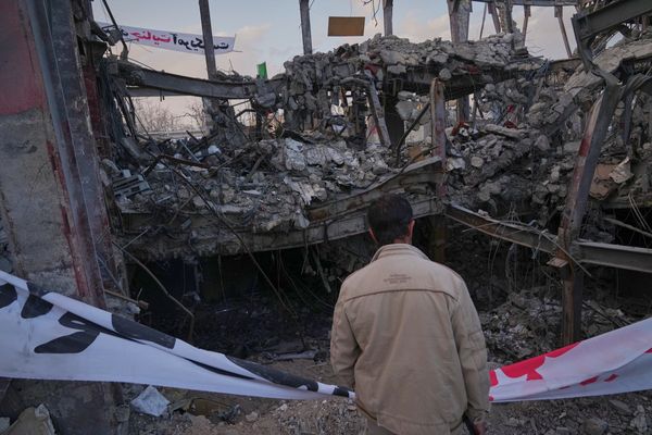

.png?w=600)