Tropical Cyclone Alfred, which had already been moving at a sluggish pace, has slowed even further now, delaying the landfall and raising serious concerns about prolonged storm impacts for Australia’s eastern coast.
Initially expected to make landfall late Thursday or early Friday, the latest forecast shows Alfred is now moving at a speed of just 7kmph, slowed down by half of its speed on Wednesday.
The storm may not reach the coast until early Saturday now, meaning millions in southeast Queensland and northern New South Wales will endure damaging winds, torrential rain, and dangerous surf conditions for much longer than anticipated.
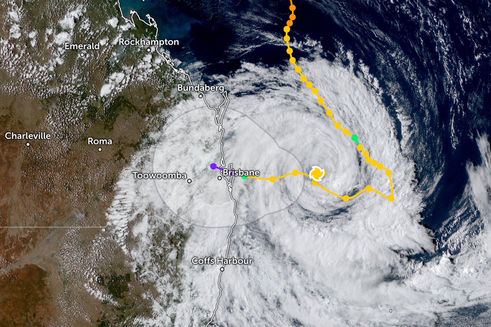
On Thursday morning, Alfred was just 240km off the coast of Brisbane, already bringing record-high waves of 12m and heavy rainfall. The Bureau of Meteorology expects the storm to stall further, potentially staying near the coast for a long time before making landfall.
"For the rest of Thursday, we will continue to see Tropical Cyclone Alfred moving west towards the southeast Queensland coast and northeast New South Wales,” the bureau said in a bulletin.
“But into Friday, it does become very slow moving and may even stall just off the coast of Brisbane as a Category 2 system.”
Experts say this sluggish movement is tied to a breakdown in the winds that usually steer cyclones.
“The slower than expected movement of TC Alfred is a result of weaker than expected steering winds than originally forecast,” Michael Barnes, research fellow at Monash University, told The Independent.
Alfred was originally moving southeast, like most cyclones do, but it encountered a high-pressure system over the Tasman Sea that blocked its path and forced it to turn west toward the coast of Australia to make a rare landfall.
The last time Brisbane saw a tropical storm reach this close to its shores, it was 1990. Gold Coast acting mayor Donna Gates said in terms of destructive winds and heavy rain, the city hasn’t seen anything like this since 1952.
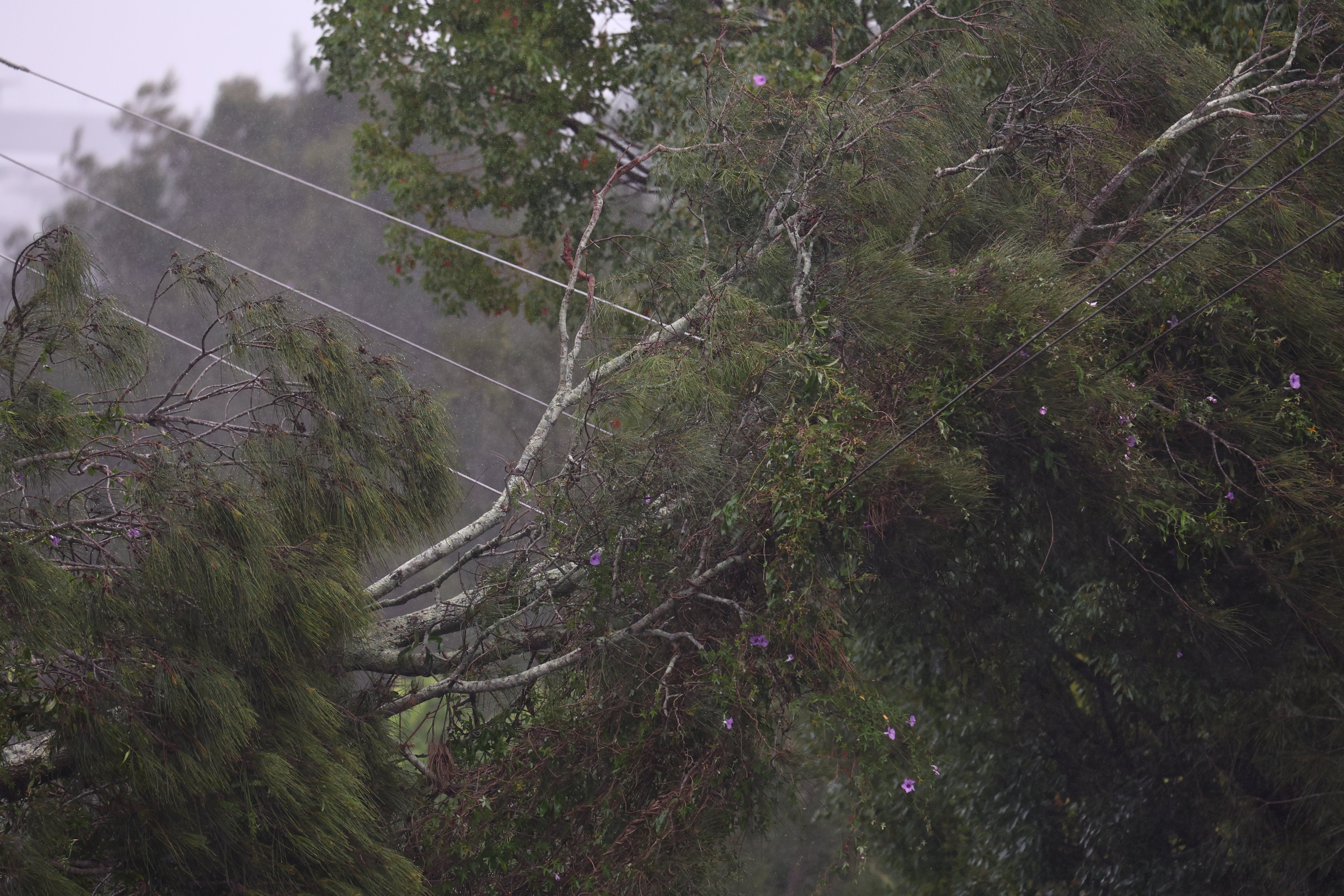
But now, the winds pushing it along have weakened, leaving it meandering offshore instead of moving steadily inland. However, the effects on the ground are increased by this, experts say.
Why slow-moving storms are far worse
A slow-moving cyclone is often far worse than one that moves quickly. The longer a cyclone stays over a region, the more rain it dumps.
“Both wind and rainfall will be prolonged over areas affected which will exacerbate the impact felt by people and infrastructure,” Mr Barnes says for Alfred. “This includes rainfall and wind as well as storm surge and coastal wave effects.”
Flood warnings are already in place, with southeast Queensland and northern NSW expecting accumulated 800mm of rain expected, with higher totals possible in some areas. Life-threatening flash flooding and river flooding are major concerns.
Northern New South Wales has already recorded over 200mm of rainfall in 24 hours while Queensland has recorded o ver 100mm in hinterland areas and the Scenic Rim by 8am on Thursday.
When rain continues to fall on an already soaked ground, the risk of life-threatening flash flooding and river flooding increases since the water has nowhere to go, overwhelming rivers, storm drains, and low-lying areas much faster. The prolonged heavy rain also means that floodwaters will take longer to recede, extending the impact on communities.
Record-breaking waves exceeding 12m have already been recorded offshore. Prolonged exposure to large waves and storm surges could also lead to severe coastal erosion, particularly along already vulnerable areas of the Gold Coast and northern NSW, experts warn.
Alfred is expected to maintain Category 2 strength for much of its approach. But the extra time over warm water could potentially give it more fuel to intensify.
“Tropical Cyclone Alfred, which has already been a slow-moving system, has further slowed down on its approach to landfall. This brings several concerns,” professor Ana Vila-Concejo from the University of Sydney, told The Independent.
“Currently, the cyclone is lingering over warmer waters, increasing the chances of further intensification before it reaches the coast.”
However, there’s also a chance it could weaken earlier. But it’s still capable of dumping massive amounts of rain, says Iftekhar Ahmed, associate professor at the University of Newcastle.
"Cyclone Alfred is a shallow system, meaning it lacks the deep convection required for rapid intensification,” he told The Independent.
“It has been brewing for over 10 days, gaining and losing strength due to fluctuating sea temperatures and cloud cover. The fact that it is moving slowly now could mean it's losing energy, but it will still carry massive amounts of moisture, making flooding a serious threat."
Why more storms move slowly now
The behaviour of Cyclone Alfred reflects a growing trend seen in tropical storms worldwide. Several hurricanes and cyclones have been found to be lingering far longer than usual. Research shows that tropical cyclones worldwide have slowed by 10 per cent over the past 70 years.
While many factors influenced contributing to its unusual track and slow movement, one of the major reasons has been warmer ocean temperatures.
“Tropical cyclones feed off the warmth of the sea, explains the deeper it is, the more heat the sea can store and radiate, creating the convection currents that form cyclones,” explains Dr Ahmed.
Sea surface temperatures near Australia are well above normal. Rising global temperatures, driven by burning coal, oil and gas, are increasing sea surface temperatures across the planet, increasing marine heatwaves and fuelling hurricanes and cyclones.
This year’s Atlantic Hurricane Season also saw an extraordinary number of storms with 11 of the 18 developing hurricane strength and five becoming major hurricanes. When Hurricane Milton devastated Florida, scientists found “bath-tub hot” waters off the coast drove its intensification.
“Tropical cyclones are clearly linked to global warming, with increasing frequency and magnitude,” Dr Ahmed said on Monday. “Alfred is also striking further south than usual, impacting northern NSW, an area that has not had a cyclone warning in over 50 years.”
Alfred’s slow movement has already forced major disruptions across Queensland. Gold Coast airport is shut down, flights are cancelled, and thousands are without power. A vast area from the Double Island Point near K’gari in Queensland to Grafton in northern NSW remain under warning.
Prime minister Anthony Albanese urged residents to exercise caution, saying that while the cyclone "has slowed up somewhat... that is not all good news".
Cyclone Alfred already ‘packing a punch’ as 70k without power - live updates
Cyclone Alfred mapped: When and where will the Category 2 storm make landfall?
Cyclone Alfred: What’s making the storm unusual and why are forecasters concerned?
Government backs end to licensed ‘wild take’ of birds of prey for falconry
‘Watershed’ moment as first legal wild release of beavers in England takes place
Urban rivers ‘vulnerable’ to pollution, MP warns after ‘massive’ spill