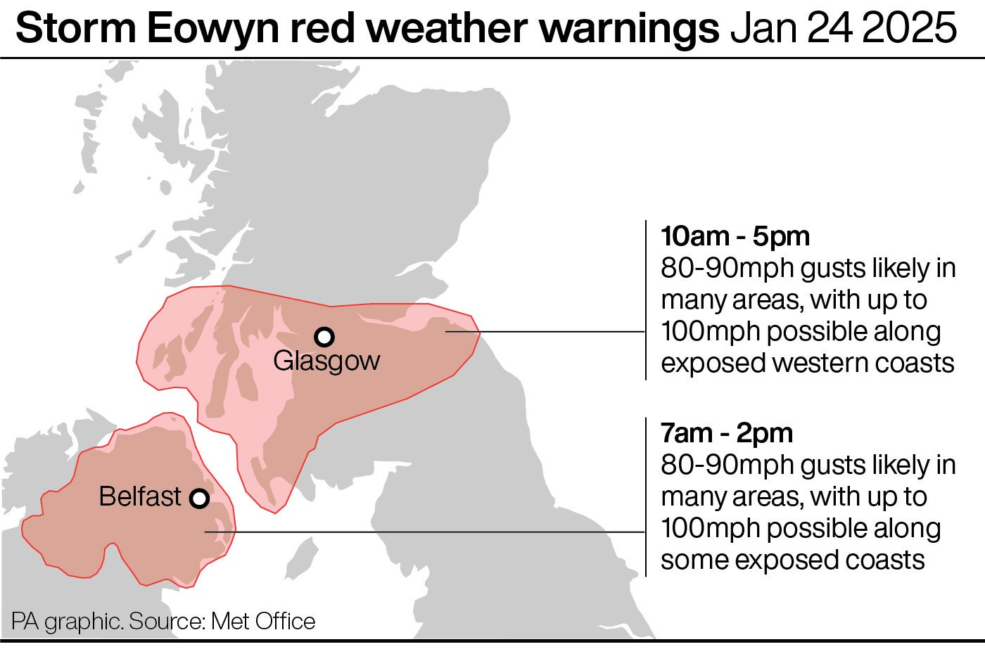
A rare red weather warnings has been issued by the Met Office for Northern Ireland and parts of Scotland as Storm Éowyn is set to bring severe winds to the UK on Friday.
The extreme weather event has seen hundreds of schools close in preparation, and dozens of rail operators halt their services. The storm marks the first time Northern Ireland has seen a red weather warning since the current system was introduced in 2011. It covers the entire country.
Parts of Scotland are also covered by the rare warnings – including Glasgow and Edinburgh – while the rest of the UK is covered by either amber or yellow warnings throughout the rest of the day.
Met Office Chief Meteorologist Paul Gundersen said: “Storm Éowyn is a multi-hazard event, with snow likely for some, rain for many and strong winds for much of the UK. As a result, a number of weather warnings have been issued, with all parts of the UK covered by one warning at some point on Friday.
“While it will be widely very windy on Friday, with additional hazards from rain and snow, the strongest winds and most significant impacts are likely in Northern Ireland and central and southwestern parts of Scotland within the Red Warning areas, where winds could gust 80-90 mph quite widely for a time, and potentially up to 100 mph for exposed coasts in particular.”
How rare are red weather warnings?
Red weather warnings are the rarest kind, issued when the Met Office believes extreme weather is very likely to occur. The event will usually bring conditions that pose a danger to life, with those in the affected areas advised to take extreme caution.
Between 2011 and 2024, there were red warnings in place on just 19 days. During the same time, 521 days saw amber warnings while 1,922 had yellow. This means a red warning has only come on average one in every 128 days that saw other warnings.
For a red weather warning to be issued, it is measured by Met Office experts againsts its ‘impact matrix.’ This weighs how high the impact from the weather event will be with how likely it is to occur. On the rare occasion that they forecast the highest of both, a red warning is issued.

Met Office Chief Meteorologist Paul Gundersen said: “We reserve the issuing of Red Warnings for the most severe weather which represents a likely danger to life and severe disruption, and that is the case with Storm Éowyn.”
They are not only issued for wind, however, and in the past have been issued rain, snow and once even ‘severe heat.’ This was the case in July 2022 for the first and only time, during a severe heatwave which saw many areas in the UK declare draught and wildfires. On 19 July 2022, the highest-ever temperature in the UK was recored in Coningsby, Lincolnshire, at 40.3 degrees.
How dangerous is a red weather warning?
A red weather warning can cause “very dangerous conditions” for those in affected areas, meaning precautions should be taken. During Storm Éowyn, the Met Office recommends staying inside, not travelling, preparing for power cuts and tying down loose items outside the home if possible.
Mr Gundersen says: “While it will be widely very windy on Friday, with additional hazards from rain and snow, the strongest winds and most significant impacts are likely in Northern Ireland and central and southwestern parts of Scotland within the Red Warning areas, where winds could gust 80-90 mph quite widely for a time, and potentially up to 100 mph for exposed coasts in particular.”
The Met Office describes high impact from wind as:
For the latest updates and information during Storm Éowyn, follow The Independent’s live coverage.


