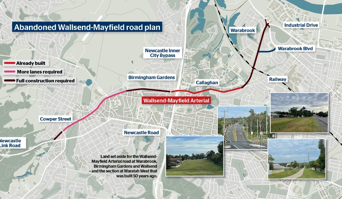
We have the need and we have the land.
The state should build a formerly planned arterial road from Wallsend to Mayfield, to relieve pressure on Newcastle Road, get heavy traffic off narrow suburban streets, and provide faster, more convenient travel.
Except for a handful of buildings that would have to be demolished, the route is ready to go, thanks to planners setting it aside in the 1960s. Seven continuous kilometres is available: some is empty land; some is a broad road corridor that we're only partly using; and, in the case of University Drive, some already has its dual carriageway.
Currently, drivers twist and turn through streets in the localities that this road would serve. To cope with demand, we have crammed four lanes into Maud Street, Mayfield, and far too much traffic goes down residential Wilkinson Avenue, Birmingham Gardens. People use overburdened Newcastle Road for as much of their trip as possible when connecting to such places as Shortland, Waratah or the university.
Instead, they could all be whizzing along a direct, dual-carriageway road that would have few intersections and could mostly be rated at 70-80kmh. Call it the Wallsend-Mayfield Arterial.
Newcastle Liberal councillor Callum Pull wants revival of the plan to be investigated. In fact, it should simply go ahead as soon as possible.
Transport for NSW cites reasons why the scheme was cancelled in 1981, particularly that planning for it was followed by construction of other roads. "The effectiveness of the surrounding network of road projects led to the Wallsend to Mayfield route being abandoned," a spokesperson says.
"It also would have involved extensive impact to properties, power supply and utilities and existing transport infrastructure."
Well, the cost of moving electricity and gas lines certainly would have to be borne. But the impact on other infrastructure and residents would be remarkably low, because former planners controlled land use around the reservations. We can see that if we take a detailed look at the land available for this superb route.
But first think about street widths, measured between property lines. An old standard in Australia is 20 metres - actually, one chain, or 66 feet. After allowing for verges (footpaths and grass), that accommodates four lanes - usually two travelling lanes and two parking lanes but, when we're desperate, four travelling lanes.
A typical arterial road, such as Tudor Street, has 30 metres between properties, accommodating seven lane-widths: usually four travelling lanes and three turning or parking lanes.
The Wallsend-Mayfield Arterial would flow straight from the end of Industrial Drive at Mayfield West with dual carriageways carrying four travelling lanes. Land has been reserved for an interchange with Maitland Road.
Heading south through Warabrook, the path is splendidly 40 metres wide and is adjoined only by light industrial sites or the rears of residential lots. No one's home at Warabrook faces it.
The reservation is so wide that it could be lined generously with trees to further divide traffic from residences.
It's intersected by Warabrook Boulevarde, which has been aligned to shorten the link with central Mayfield. Warabrook Boulevarde is also 40 metres wide, and former planners ensured it was used only for light industry.
So, Warabrook really was built to accommodate this excellent road plan.
Heading south, the Wallsend-Mayfield Arterial needs a bridge over the railway. And I hear doubtful readers say: "Fat chance. We're still queuing at Adamstown gates."
My response: let your local member of state parliament know what you think.
South of the railway, the road would meet University Drive, which is in fact Wallsend-Mayfield Arterial Stage 1, completed in 1971-72.
Arriving at Birmingham Gardens, we face a reservation that's south of and parallel to Wilkinson Avenue. It was part of the old Wallsend coal railway. The corridor is only 20 metres wide, but that's enough for a four-lane dual-carriageway road, because footpaths aren't needed.
As an old railway alignment, it isn't faced by houses. We could replace fences with sound barriers.
One kilometre further along we enter Cameron Street, which becomes Cowper Street. Here we have at least 40 metres to play with, because the empty railway corridor lies alongside the current road.
So much width is available that travelling lanes can be separated from houses by adding local-access side roads. On the northern side of the alignment, where the railway used to be, the houses don't face the reservation.
In central Wallsend, three post-war buildings would have to go: a telephone exchange, a council hall and a church. None is an architectural beauty. This part of the route also has the greatest impact on local amenity, because it passes along the edge of the Wallsend shops - but not through the middle of them.
And in central Wallsend the road would squeeze past an old railway goods shed, which we must preserve. The available width is about 25 metres, and turning lanes are needed, too. But various configurations can be used to preserve four free-flowing travelling lanes.
At the Lake Road intersection we keep going straight into another, short reservation. Two houses on the northern side would probably have to go, and what's now a pretty creek would have to run between the carriageways.
Then the Wallsend-Mayfield Arterial meets the Newcastle Link Road for motorway connections. I have previously argued that it should eventually extend south as a West Lake Motorway that would take traffic away from such suburbs as Booragul, Fennell Bay and Toronto.
Eventually we could have a continuous, fast, high-capacity road from Port Waratah to Morisset.
But the west-lake idea is only for long-term planning. What should be for short-term execution is building the Wallsend-Mayfield Arterial.


