Satellite images reveal the scope of devastating wildfires in the Canadian northwest where an entire capital city had to be evacuated due to approaching flames.
Earlier this week, the European Earth-observing satellite Sentinel-2 observed several blazes raging in Canada's Northwest Territories, spreading thick plumes of smoke across an area wider than 60 miles (100 kilometers). The images were taken just days before authorities ordered the Territories' capital of Yellowknife, a town of 20,000, to be completely evacuated due to the encroaching flames. According to the Guardian, 236 wildfires are currently active across the Territories.
British Earth-observation scientist Simon Proud shared satellite images of similarly extensive smoke plumes spreading across British Columbia, a province to the south of the Northwestern territories.
Related: Wildfire smoke is warming the planet more than previously thought, scientists say
"Worrying view of #fires in Canada yesterday, taken by [the National Oceanic and Atmospheric Administration's] GOES-18 weather sat," Proud, who is a scientist at the U.K. National Centre for Earth Observation, said on X, formerly known as Twitter. "Look how the valleys are filled with smoke. Terrible air quality for anyone in the region."
Worrying view of #fires in Canada yesterday, taken by NOAA's GOES-18 weather sat.Look how the valleys are filled with smoke. Terrible air quality for anyone in the region.Today expected to be another bad day for fires. pic.twitter.com/XLSHavSD69August 17, 2023
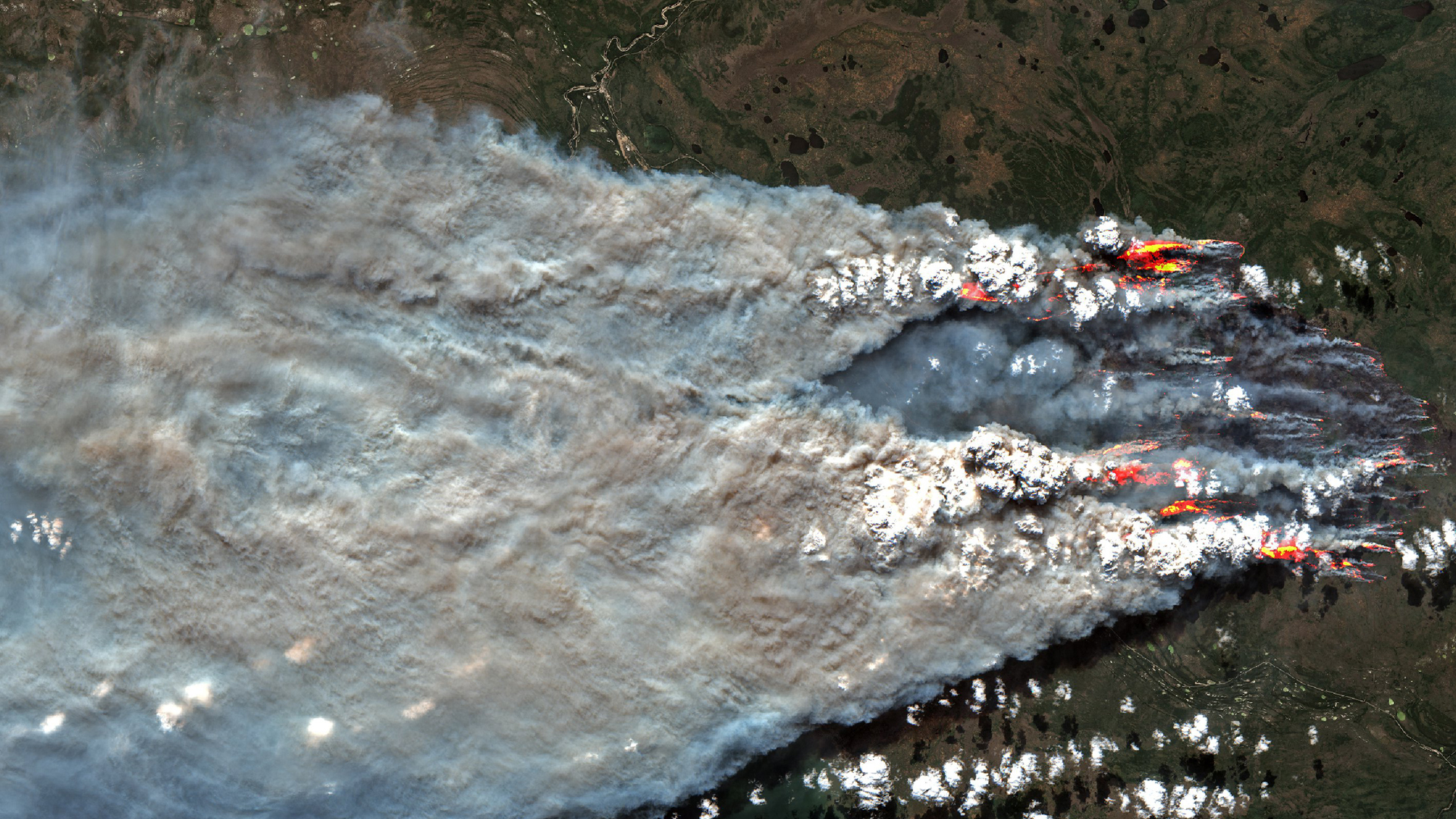
Another image sequence from GOES-18 shared by the Cooperative Institute for Research in the Atmosphere (CIRA) shows a large storm cloud arising from the wildfire smoke.
"A wildfire in southern British Columbia produced a brief pyrocumulonimbus cloud this evening," CIRA said in a post on X. "This high resolution satellite imagery from GOES-18 shows the explosiveness within the smoke plume."
A wildfire in southern British Columbia produced a brief pyrocumulonimbus cloud this evening.This high resolution satellite imagery from GOES-18 shows the explosiveness within the smoke plume. pic.twitter.com/pU52VKCNiHAugust 17, 2023
Cardiff University climatologist Ian Hall said that wildfires across Canada have already devoured boreal forests covering an area larger than the entire country of Greece. Hall made the statement on X, sharing an image showing a map of Canada covered in red dots highlighting the locations of dozens of out-of-control blazes across the country.
The Canadian #wildfires have now burned boreal forests covering more than the entire land area of #GreeceToday: Out of control = Red symbolsSmall = 0 to 100 HaMedium = 101 to 1000 HaLarge = >1000 HaBeing held = YellowUnder control = BlueOther = Orange#ClimateCrisis pic.twitter.com/aUZA86ihesAugust 15, 2023
Wildfires erupted early this year in Canada due to the unusually warm and dry weather in spring. In early June, plumes of smoke from wildfires in Nova Scotia and Quebec in the eastern Canadian spread all the way to the U.S. Northeast, suffocating New York and surrounding areas in record-breaking air-pollution.
According to data from the European environment monitoring program Copernicus, carbon emissions from Canada's wildfires emitted this year have already doubled the country's previous annual record from 2014. As of the end of July, the carbon emissions total stood at 138 megatons, Copernicus said in a statement on Aug. 3.