It's been a pretty quiet hurricane season in the Atlantic basin so far this year, but it's not over yet.
As we approach the peak of the 2024 hurricane season, there are a pair of tropical waves to watch coming off the coast of Africa as well as a newly formed strengthening tropical system in the Gulf of Mexico, Tropical Storm Francine, expected to become a hurricane by the middle of the week.
Francine became a tropical storm on Sept. 9 and as it experiences conditions that are conducive for strengthening, the storm is expected to reach hurricane strength and make landfall sometime on Wednesday (Sept. 11) along the western edge of the Gulf Coast.
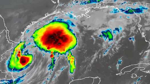
The National Oceanic and Atmospheric Administration (NOAA)'s GOES-East satellite has been working overtime following the progression of the tropical system, documenting its every move just like a drone camera during your favorite NFL football game. By using different tools and products aboard the satellite, forecasters can have a birds-eye view from space of the storm's movement and clues to its development.
During its formation, meteorologists used the satellite's Advanced Baseline Imager (ABI) and Geostationary Lightning Mapper (GLM) instruments to watch the storm as the sun rose on Monday (Sept. 9). In the animation below, you can get a crisp high-resolution look at the size of Francine and watch the amount of lightning strikes increasing within it, signaling the storm is gaining strength. The channel used shows the visible images, meaning you can only see data from sunrise to sunset.
.@NOAA's #GOES16 is closely monitoring Tropical Storm #Francine as it strengthens in the Gulf of Mexico this afternoon. Keep track of Francine with our #Hurricane Tracker: https://t.co/XrnCltqBtl https://t.co/qzk69AY9vo pic.twitter.com/Czb2C5LLMrSeptember 9, 2024
Infrared satellite imagery might have less of a resolution than visible, but it's available around the clock. If we look at this satellite time-lapse that began the day before Francine became a tropical storm, using the ABI instrument, you can see how the cloud tops get colder over time (more dark and white bubbling up). This is an indication of powerful vertical motion extending high up in Earth's atmosphere (temperatures typically decrease with height the farther away you get above the Earth's surface).
Infrared imagery via @NOAA's #GOESEast 🛰️ is tracking Tropical Storm #Francine over the western Gulf of Mexico this morning. #Hurricane Warnings and #TropicalStorm Warnings are in effect for the Louisiana coast.Latest: https://t.co/28Ld19PKYo pic.twitter.com/9GTNBYm4QcSeptember 10, 2024
By getting a clearer picture of tropical systems as they develop and a better understanding of their movement and intensification, forecasters are able to provide those in their paths more time to prepare and a better idea of what hazards can be expected from these storms.
For the latest updates on watches/warnings and forecasts for Francine, information is available from NOAA's National Hurricane Center website and through trusted local media sources.