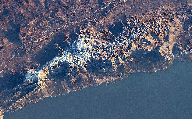
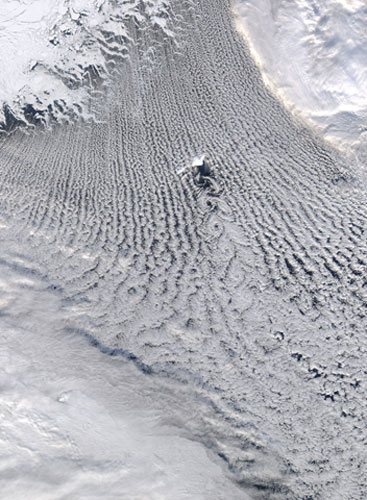
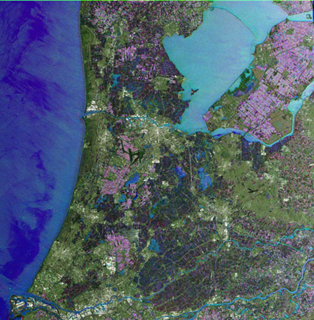
The Biokovo Range in Croatia is part of the Dinaric Alps that extend along the coastline of the Adriatic Sea. The range itself is a national park and the nearby city of Makarska, located between the mountains and the sea, is a popular tourist destination. The highest peak in the range is Sveti Jure at 1,762m. The Biokovo Range mainly comprises limestone rocks, deposited in relatively warm, shallow waters. Later tectonic processes lifted and exposed the carbonate rocks to erosion, leading to a distinctive surface known as karst topographyPhotograph: NASAIn February, cold northerly winds encountered moist air over the Greenland Sea and generated dozens of parallel rows of clouds - commonly called "cloud streets" - in the skies around the island of Jan Mayen. The island added its own influence to the weather, creating an obstacle to the prevailing winds. Like water in a stream as it flows around a boulder, the air swirled into a string of spiralling eddies, known as "von Karman vortices"Photograph: NASAThis Envisat image shows the Netherlands. Amsterdam is visible in white on the south bank of the the North Sea Canal and extends in an east-west direction, left above the image centre. Rotterdam and the province of Zeeland are both visible at the bottom left of the image. Rotterdam port is the largest port in Europe, stretching over 40km in lengthPhotograph: Envisat/ESA
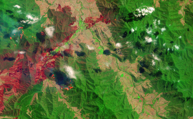
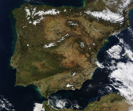
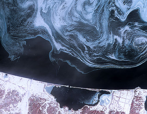
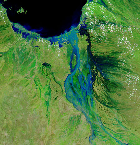
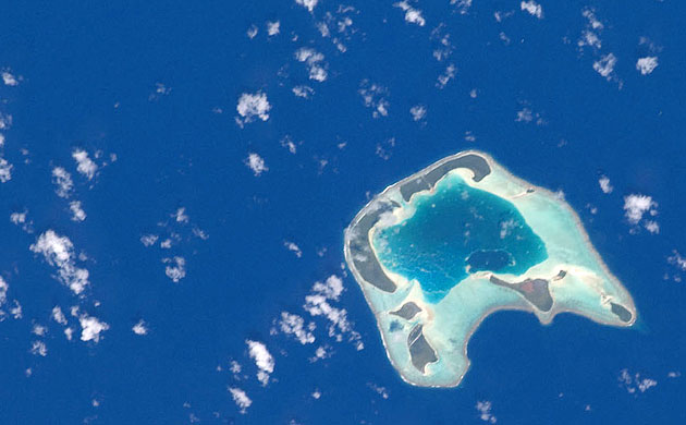
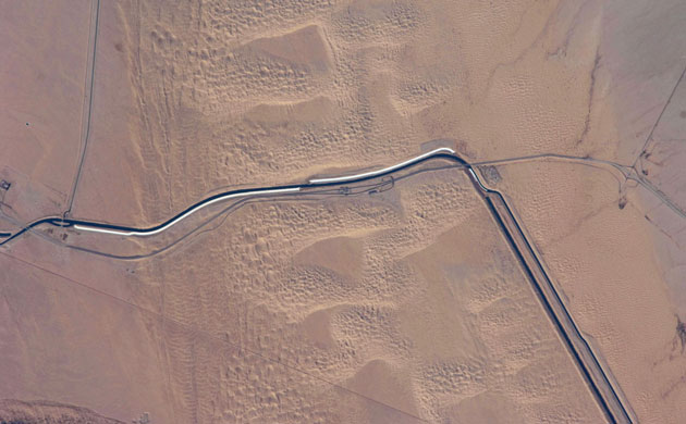
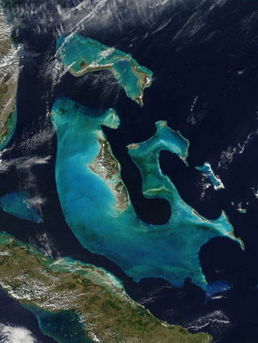
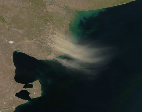
Although most of the deadly bushfires that ravaged Victoria in January and February burned in the area between Melbourne and Lake Eildon, devastation also came to more northern parts of the state. This false-colour image from a Nasa satellite shows part of the 30,700 hectare (75,861 acre) Beechworth fire, which reportedly killed at least two people. Unspoilt vegetation is bright green, while burned areas are dark pink. The bright pink areas are often a sign of open flame in this type of image Photograph: NASAPortugal and Spain share the Iberian Peninsula in south-west Europe, shown here in this image. A central plateau, the Meseta, dominates the peninsula at 610m above sea level. Madrid, the Spanish capital, sits on top of the Meseta and can be seen as a grey smudge near the peninsula's centre. To the north of Madrid are four mountain ranges that cross the Meseta: the Sierra de Gredos and the Serra de Guadarrama, which run north-eastward; the Serrania de Cuenca, which runs south-eastward; and the Sierra de la Demanda, which sits at the apex of the other three rangesPhotograph: MODIS/NASASea ice formed delicate swirls of blue and white in the Okhotsk sea in February. This image shows the northern coast of Japan's Hokkaido Island. In this false-colour image water is dark blue, sea ice and snow are pale blue or white and vegetation is red. South of the sea ice lies an area of open water. South of the open water is the coastline, partially covered with snow. The enclosed water body along the coast is Saroma-ko and thin layers of ice float at both the east and west ends of this lake. The Sea of Okhotsk has long been home to our planet's southernmost Arctic sea ice. Photograph: NASAEven while south-eastern Australia battled high heat and deadly fires in February, much of the rest of Australia flooded. Wet-season rains brought severe flooding to Western Australia, Queensland, and New South Wales. The most widespread flooding was in Queensland, where more than 1m km sq reportedly flooded. The image shows flooding along the Flinders river system in northern QueenslandPhotograph: MODIS/NASATetiaroa Island is part of the Society Islands archipelago in the southern Pacific Ocean, one of several island clusters in French Polynesia. Tetiaroa is an atoll comprised of thirteen small islets (or motus). This astronaut photograph illustrates the typical circular appearance of a fully developed atoll. Tetiaroa Island is also known as "Marlon Brando's Island". The late film star purchased the atoll from the French Polynesian government between 1966 and 1967. While the motus were his property, the government retained the rights to the coral reefs and lagoons to preserve control of marine resourcesPhotograph: NASAThe All-American canal - the largest irrigation canal in the world and a key landmark along the US-Mexico border - shows up in this astronaut's photograph. This image captures about 15km of the important infrastructure corridor just west of Yuma, Arizona. The prominent dark line crossing the image is the canal, which is crossed in this view by Interstate Highway 8. The canal carries 740.6 cubic meters (26,155 cubic feet) of water per second westward from the Colorado river to support the intensive agriculture of California's Imperial Valley, to the northwest, and nine cities, including San Diego. The canal system is the Imperial Valley's only source of water and allows irrigation of more than 2,000 km sq of agricultural fields. The Coachella Canal, one of four main branch canals, leads water north to Imperial ValleyPhotograph: NASAThe shallow aqua waters of the Bahamas stand out in this image, captured by the Aqua satellite on 12 February. This archipelago consists of some 700 islands and 2,000 cays. Near the image center, Andros Island is surrounded by the bright blue halo of Great Bahama Bank, a coral reef limestone platform which was slowly inundated by rising sea levels as the last ice age glaciers melted. The white limestone under the shallow waters is what causes the bright blue halo. The margins of the shelf can drop off steeply - for example on the Atlantic Ocean side (right of the island in this image), a nearly vertical drop to depths of 4,000m explains the thinness of the blue perimeter, while on the western side, the shelf is much widerPhotograph: MODIS/NASAContinuing an intermittent pattern from the previous month, more dust plumes blew off Argentina's coast in February, forming slight arcs that move in a counter-clockwise direction over the Atlantic Ocean. This part of Argentina is also known as Patagonia, with arid landscapes sculpted by relentless winds. The dry conditions were exacerbated in early 2009 by the worst drought in a generation. The source of the plumes appears to be an agricultural region north of Golfo San MatiasPhotograph: MODIS/NASAMore than mere colors on the page, the blotches of brown and cream with only faint dustings of green in this image represent the impact of one of the worst droughts in southern South America in decades. Each tiny dot of brown is a two-km sq of land (250m per pixel) where plants were struggling to grow in the hot, dry weather. Since northern Argentina, Uruguay, and southern Brazil contain rich, intensively cultivated land, the dots include fields of corn, cotton, soy, wheat or pastureland for grazing cattle. The brown tones reveal that these plants were growing far less vigorously than average in late JanuaryPhotograph: NASA
Sign up to read this article
Read news from 100’s of titles, curated specifically for you.