The Auckland light rail decision has created excitement – but also trepidation among those concerned about the project’s significant costs and potential effects. One of those in the ‘excited’ camp is Kathleen Bunting, who explains the city-shaping benefits.
► How is the Central City to Māngere (CC2M) project ‘city shaping’?
CC2M is quite rightly described, by Grant Robertson, Michael Wood, Phil Goff and the Indicative Business Case summary report, as a ‘city-shaping’ project - but what does that really mean?
We can get an idea by looking at examples overseas, especially our nearest neighbours in Australia where light rail projects have been retrofitted into existing urban areas to revitalise and transform them (for example in the Sydney CBD, Parramatta and Newcastle).
However, some of the city-shaping changes for Auckland will also be quite specific to our context, such as our particularly narrow urban isthmus, the cultural significance of both the land and waterbodies to Mana Whenua, and the differing social demographics along the proposed corridor.
► A step change in access to places people live, work, learn and play
I hope it’s becoming clear to the Auckland public that transporting tourists or businesspeople to and from the airport is not the primary purpose of the project. It is about supporting sustainable growth in our city, by improving accessibility of people to the places they live, work, learn and play.
It’s also about equity of access - supporting people from all different mobilities, socio-economic circumstances, age groups, family circumstances and reasons for travelling. Light rail caters for everyone, including the mobility impaired (disabled, parents with prams, elderly), those that don’t have access to a car, and those that want a more sustainable transport choice.

The selected route will enable people living in areas like Māngere and Mt Roskill, who have been historically under-served by public transport, to travel more easily to work and education. The CBD, Onehunga and the airport precinct are key employment nodes and much of the Onehunga and airport workforces live in south-west Auckland, close to the recommended route. In fact, workers commuting to and from the airport precinct are expected to use the service more than travellers passing through the airport.
There are also many schools along the corridor, and the central city segment will significantly improve public transport access to the city’s university precinct. It will enhance connectivity to social services and facilities, cultural, sport and recreation facilities like the waterfront, restaurants and shopping, festivals and events in the CBD, Eden Park, the city's maunga, and the Onehunga and Māngere Bridge foreshores.
A high-quality light rail system will relieve pressure on land demand for cars and parking, and will have the capacity to carry significantly more people per square metre than our current bus and car-based system. In this way, it will improve both the physical capacity for density in our city, and the functioning of higher density development.
CC2M will support development of denser and wider housing close to rapid transit, and encourage more people out of their cars and onto public transport. This shift onto public transport is critical to support Auckland’s sustainable growth, to mitigate traffic and bus congestion in the CBD and on key corridors (like Dominion Road, SH20 and Symonds Street), and to meet New Zealand’s net zero carbon target by 2050.
A key way to maximise these transport and density benefits will be seamless integration of the light rail project with the broader public transport and active mode network, as well as expansion of the rapid transit network to the north and north-west. This is why it’s essential the project is future proofed for, and integrated seamlessly with, these future connections, the planned Additional Waitematā Harbour Connection, and the wider Auckland bus, heavy rail and active mode networks.
► Unlocking housing and urban development opportunities along the corridor
In a December 2021 article ‘Shaping Auckland’s future with Light Rail’, my colleagues Matt Lindenberg and Bryce Julyan talked about how the project would enable urban regeneration and housing intensification along the corridor, especially in walkable catchments from stations. The National Policy Statement on Urban Development now directs Auckland Council to enable high density (minimum six-storey) development around rapid transit stops. This means very careful consideration will need to be given to stop locations, and good master planning and interventions like plan changes will be needed within those precincts to maximise the benefits.
The indicative business case summary report predicts that CC2M integrated with planning interventions (e.g. policies and provisions that enable well-designed, medium to high density housing) will enable a doubling of quality development along the corridor with up to 66,000 new homes . That would be a step change in addressing Auckland’s housing supply issues – and critically, will enable housing and other mixed uses next to high quality, frequent and reliable public transport.
The recommended route also connects to two major areas of social housing redevelopment, proposed by Kāinga Ora, at Mt Roskill and Māngere, as well as other key urban redevelopment opportunities at Wynyard, Dominion and New North Roads junction, and around the Onehunga and Māngere town centres.
CC2M will undoubtedly attract significant investment in high density housing and commercial developments close to light rail stops, and the value of this land will likely increase. Land value increase around rapid transit stops (especially within 400-500m) has been the experience elsewhere, including Sydney, and was predicted by Auckland Council in 2018 . This is a key reason why private entities are interested in investing in rapid transit around the world (It generally isn’t to make money off the actual services.)
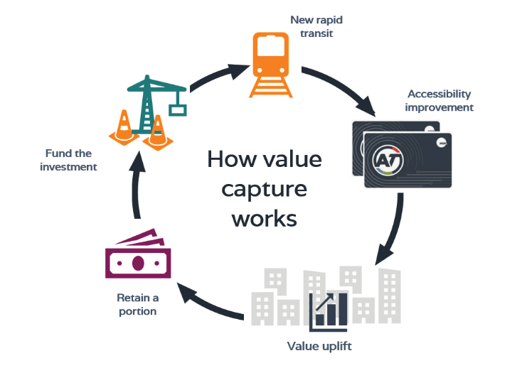
Although land value increases are a genuine concern in relation to housing and rent affordability, there is also a real opportunity to use this value increase to help fund major projects like this one, and/or to capture this value for public benefit like social housing. This is a concept known as ‘value capture’ (see figure above), and is one way to minimise public costs and maximise benefits of the project overall.
► More space for better uses in the CBD, and Dominion Road/Sandringham Road corridors
Light rail will enable Auckland Transport to remove a substantial number of buses from key routes in the city. This applies mainly to those buses operating along the CBD-Dominion Rd corridor, but also the Sandringham Rd and Mt Eden Rd corridors.
The actual benefit in relation to buses is that the current CBD-Dominion Rd corridor is at or nearing capacity – effectively constrained by the numbers of buses that can enter the CBD, particularly through the Symonds St choke point. This means another solution is required – preferably one that does not utilise existing corridor space, like the preferred tunnelled light rail solution.
A key benefit of an underground route through the city as far as Mt Roskill is the additional space and flexibility this will bring at the surface to congested road corridors like Queen St and Dominion Rd. It will mean more room for walking, cycling and scootering, high-quality public spaces, festivals and events, active street frontages and maybe even outdoor dining on Queen St.
This is already envisaged as part of the City Centre Masterplan 2020, which seeks to pedestrianise much of Queen St and assumed light rail at surface along that road but would also work well with tunnelled light rail. In fact, light rail underground will make even more room for these active and lively uses of space and place.
The project should also mean less noise and cleaner air in the CBD catchment and other road corridors (relative to doing nothing). All of this will make these corridors much more pleasant, safer spaces to be and will change the way we use and enjoy them.
► Helping to meet our greenhouse gas reduction targets
The indicative business case notes New Zealand’s net zero carbon target by 2050 is based on a tripling of public transport trips within Auckland. This tripling simply won’t be possible without a high-quality public transport network, including new rapid or mass transit corridors like this one. CC2M will contribute to this target by shifting more journeys onto public transport and enabling more intense development of housing and mixed uses close to rapid transit stops.
► Maximising the benefits of CC2M
In summary, CC2M is a significant opportunity for Tāmaki Makaurau to improve access, connectivity, travel choice, housing and urban development. It is also expected to contribute to placemaking along the corridor, help to meet our greenhouse gas reduction targets, and have various other cultural, environmental, social and economic wellbeing benefits.
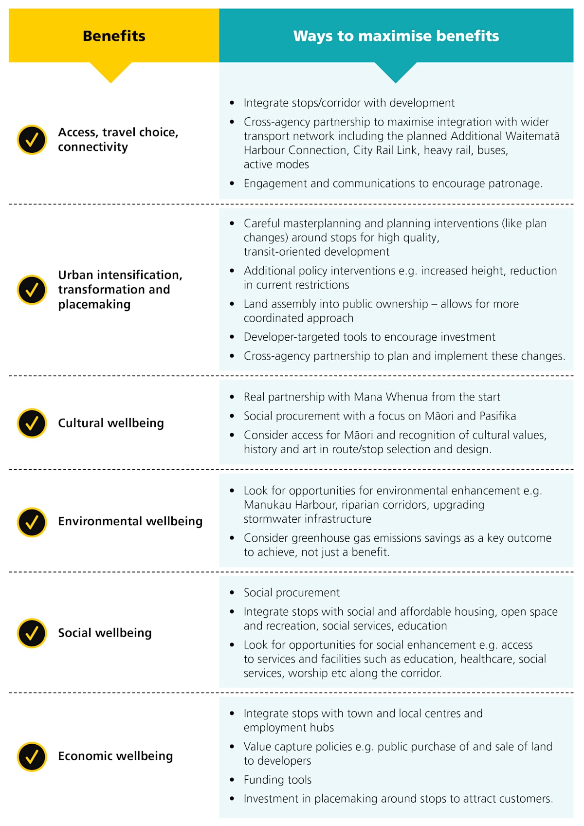
The indicative business case talks in some detail about ways to maximise these benefits – and particularly the importance of integrated urban interventions in tandem with this project. The table below is my summary of those interventions and other ways to maximise the project’s benefits.
► But what are the trade-offs for all these benefits?
Clearly one of the key trade-offs of this project is monetary. Ways to balance the financial costs with the project’s benefits will be a key focus of the next, detailed business case phase. Another trade-off will be the adverse effects of the project’s construction and operation, such as business and community disruption.
In the world of major infrastructure, disruption/effects are an unfortunate reality and cannot be avoided entirely. This is particularly true in an already urbanised, narrow isthmus with significant cultural, environmental and social values like Tāmaki Makaurau.


