A new satellite photo has captured a somber aerial view of the devastating wildfire that burned through the town of Lahaina on Hawaii's Maui island last week.
On Aug. 8, fast-moving flames appeared on Lahaina's border and rapidly spread through the town, burning down buildings, exploding cars and filling the air with ash and smoke. Many survivors, who either fled the town or escaped into the ocean, reported knowing almost nothing about the fire until the flames were almost right on top of them, CNN reported.
At least 99 people were killed by the Maui fire, making it the most deadly U.S. fire in more than a century. But the death toll is expected to rise significantly as emergency responders continue to search destroyed buildings for people who are still missing, Hawaii governor Josh Green told CNN.
Related: Wildfire smoke spreads across the U.S. in striking image from space
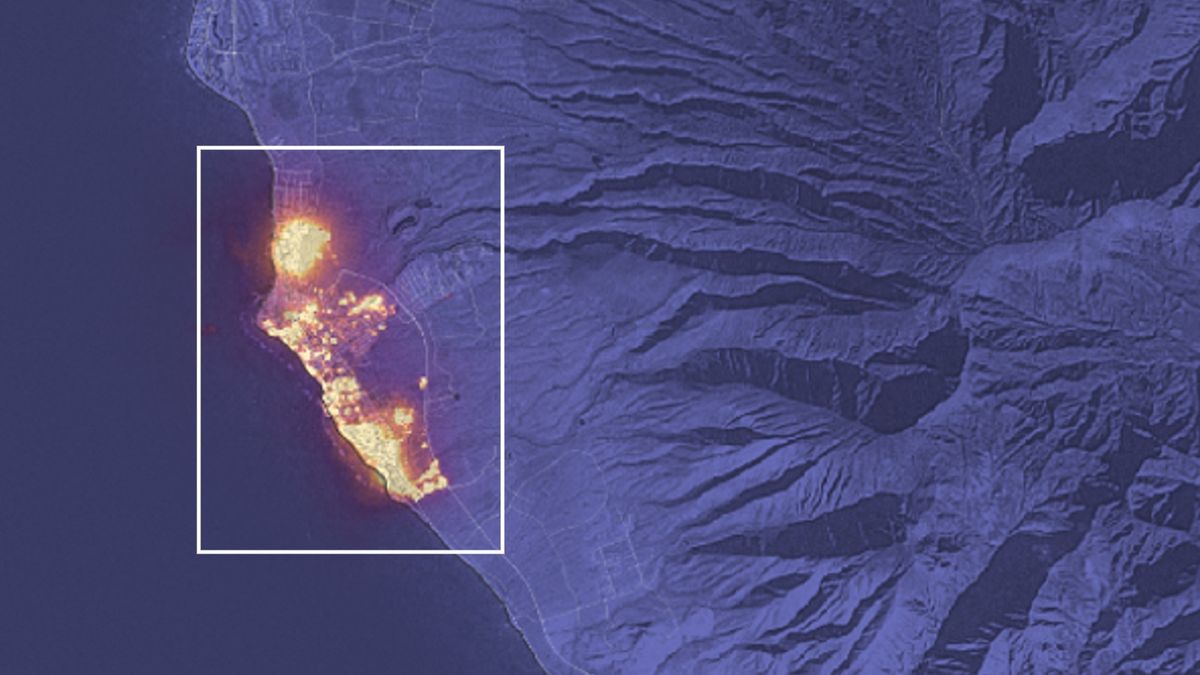
The Landsat 8 satellite, which is co-owned by NASA and the U.S. Geological Survey, captured an image of Maui at around 10:25 p.m. local time on Aug. 8, which reveals the fires almost completely engulfing Lahaina, as well another large but less deadly wildfire northeast of Kihei. The satellite image shows the spike in infrared radiation given off by the flames overlaid on a natural-color image of the island.
The Lahaina fire moved rapidly because it was fanned by unusually strong winds, which were fueled by a strong high-pressure area to the north of the island and the remnants of Hurricane Dora to the south, according to NASA's Earth Observatory. The gusts ranged from 45 to 67 mph (72 to 107 kph). Green said that at its peak, the blaze traveled at around 1 mile (1.6 kilometers) every minute.
The U.S. Federal Emergency Management Agency has said it is too early to calculate the cost of the damages caused by the fires, but Green told CNN the losses could equate to up to $6 billion. "This is the largest natural disaster we've ever experienced [in Hawaii]," he added. "It's going to also be a natural disaster that's going to take an incredible amount of time to recover from."