The UK will face more freezing weather this after a particularly chilly weekend saw temperatures plummet to -8C overnight.
Temperatures could drop as low as -6C in parts of Scotland this week as the cold weather shows no signs of letting up, according to the Met Office.
Met Office spokesperson Stephen Dixon told The Independent that while daytime temperatures would stick to the mid-single figures and that people could expect “colder than average weather” throughout the week thanks to cold easterly winds from Scandinavia.
He said: “There’s a chance of some sleet and snow over high ground in places, though this isn’t particularly unusual for the time of year. To lower levels, any rain is more likely to be drizzly in nature.”
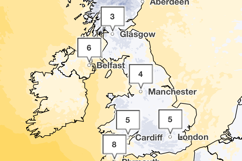
The Met Office has predicted hill snow in the north and east for Monday. This will continue into Tuesday, which is set to remain grey and cold for most with some sunny spells developing across northwest England and western Scotland.
Between Wednesday and Friday, the forecaster said it would be “cloudy with some patchy rain and hill snow developing at times”, predicting an “increasing risk” of heavy rain in the far west on Friday.
Met Office meteorologist Marco Petagna said on Sunday: “In the places with the clearest skies we could get down to minus 5C, minus 6C again tonight.
“But elsewhere any frosts could be quite patchy, because we’ve got the wind and the cloud around it’s stopping the temperatures getting too low.
“Most places away from the north west of the UK just about escaping the frost by the looks of things.”
Temperatures will struggle to reach mid-single figures at best in many areas today
— Met Office (@metoffice) February 10, 2025
If we add on the effect of the cold easterly wind it will generally feel more like freezing 🌡️📉 pic.twitter.com/3hFPB6VsNK
A number of yellow cold health alerts remain in place across northern England and the South East. The UKHSA said they will remain in place until 11 February.
The UK’s cold snap comes the European Space Agency Copernicus marked the warmest January ever was recorded globally, defying expectations that 2025 might be cooler than previous years.
While the UK may have experienced a cooler January than on average, it faced a number of extreme weather patterns as Storm Eowyn brought “once in a generation” hurricane-force winds to the UK.
Strategic lead for climate at the European Centre for Medium-Range Weather Forecasts, Samantha Burgess, explained: “A much larger area of the planet’s surface was much, much warmer than average.”
Today:
Cloudy, with outbreaks of rain and drizzle. Some hill snow is possible, mainly in the north and east. Drier and brighter for parts of Northern Ireland and northwest Scotland, with some sunshine here. Feeling cold, with a brisk easterly wind.
Tonight:
Staying mostly cloudy overnight, with further outbreaks of rain, sleet and hill snow across central and eastern parts. Drier in the west, with a patchy frost under any clear skies.
Tuesday:
Tuesday will remain grey and cold, with some rain and hill snow in the north and east. A few sunny spells developing across northwest England and western Scotland. Breezy.
Wednesday to Friday:
Often cloudy with some patchy rain and hill snow developing at times. An increasing risk of some heavier rain in the far west come Friday. A cold easterly breeze continuing.

.png?w=600)