Support truly
independent journalism
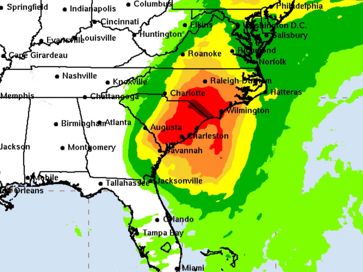
Tropical Storm Debby has left at least five people dead after it made landfall as a Category 1 hurricane along Florida’s Big Bend coast on Monday morning, before charting a path through parts of Florida, Georgia and South Carolina.
The storm continues to drift through southern Georgia and eastern South Carolina as of Tuesday after crossing the Florida-Georgia border on Monday evening.
The National Hurricane Center (NHC) has urged both states to prepare for “catastrophic flooding,” in an update on Tuesday morning. Deadly hazards remain in Florida including downed power lines and severe flooding, the NHC added.
South Carolina has already experienced harsh conditions, with two tornadoes wiping out power lines and causing damage to homes on Edisto Beach and Seabrook Island. The city of Charleston is set to face historic rainfalls of up to 24 inches, which is expected to peak on Wednesday.
The storm has so far taken the lives of five Florida and Georgia residents, including two children, a 19-year-old, a 38-year-old woman and an unidentified trucker.
Debby is expected to move slowly off the southeast coast and into the Atlantic Ocean by late Tuesday, where it is likely to meander for 24 hours before turning back towards the coast by Thursday.
It is expected to then move through North Carolina before reaching New England by Sunday.
The NHC first announced that the storm had come ashore near the coastal town of Steinhatchee in Taylor County, Florida, at approximately 7am ET on Monday with maximum sustained winds of 80mph.
Debby was upgraded to a Category 1 storm on Monday morning before being downgraded back to a tropical storm. More than 16 inches of rain were dumped on parts of central Florida.
The director of the NHC Jamie Rhome told the BBC that the storm will cause “catastrophic flooding”.
The National Weather Service (NWS) also gave a tornado watch update, which predicted almost 11.7 million Florida and Georgia residents could be exposed to tornadoes in locations ranging from Sarasota, Florida to Savannah, Georgia.
More than 350,000 residents and businesses were left without power during peak outage across Florida, according to PowerOutage.us.
Florida Governor Ron DeSantis said some 17,000 linemen are working to restore electricity.
Debby grew in strength in the warm waters of the Gulf of Mexico. DeSantis declared a state of emergency on Sunday and warned residents to “make sure you’re executing your plan now”. Florida residents began boarding up their windows and evacuating homes in storm surge evacuation zones.
During a briefing on Monday morning the Florida governor also warned citizens not to “tempt fate” by driving in torrential conditions, which he said would risk “traffic fatalities”.
Once over the Atlantic, Debby is not expected to regain hurricane strength, meaning South Carolina, Georgia, and parts of Florida’s northeastern coasts are under tropical storm rather than hurricane warnings.