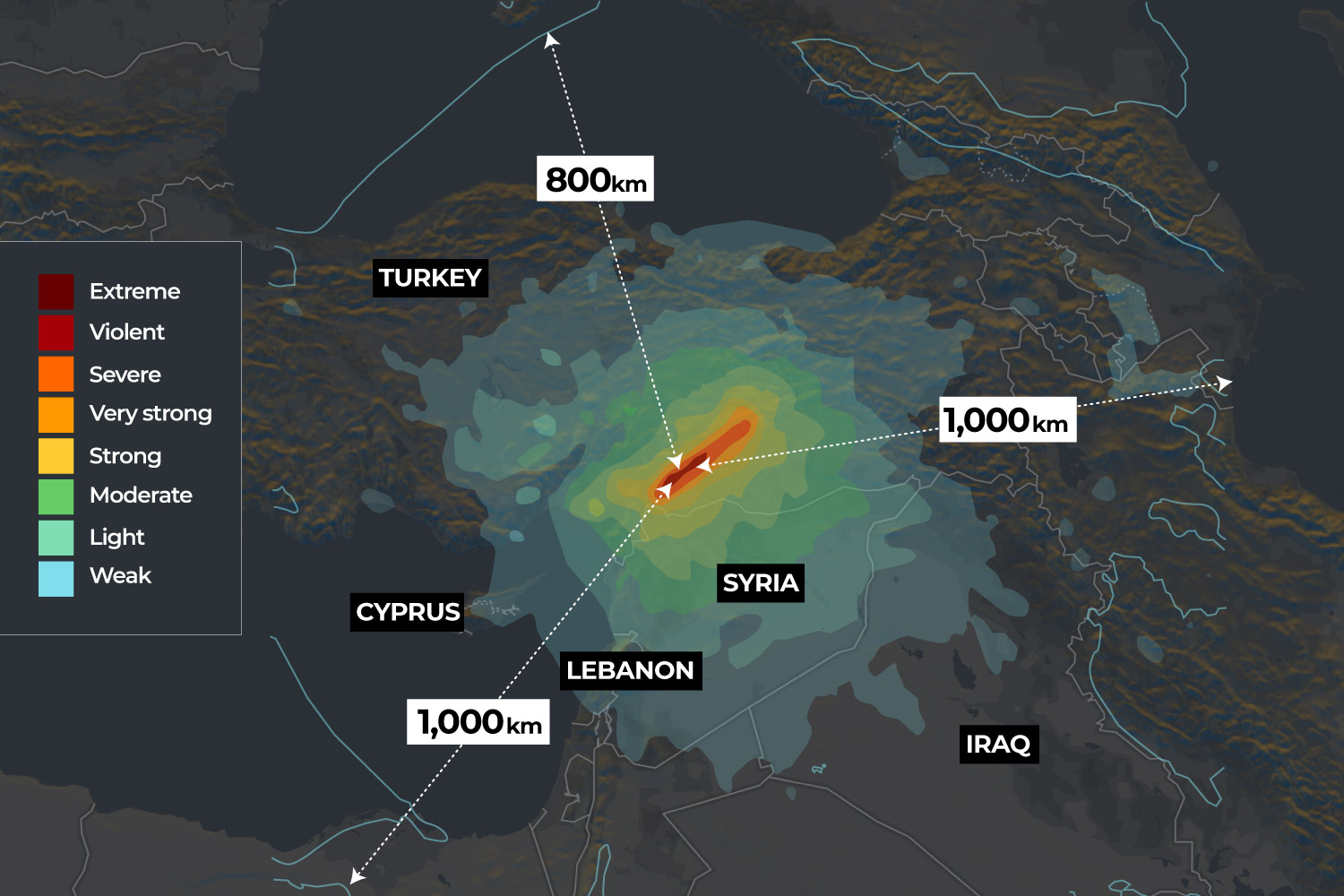
Two large earthquakes struck the southeastern region of Turkey near the border with Syria on Monday, killing thousands and toppling residential buildings across the region.
The first earthquake measuring 7.8 on the Richter scale struck at 4:17am (01:17 GMT) and was centred in the Pazarcik district of Turkey’s Kahramanmaras province. Less than 12 hours later, a second magnitude 7.6 tremor struck the same region. The tremors were felt by millions of people across the region up to 1,000km (621 miles) away. Magnitude 7 earthquakes are considered major.
Since then, Turkey has been hit by more than 100 aftershocks of magnitude 4 and greater. Aftershocks are smaller earthquakes that occur in the same general area following a major earthquake.

Which areas were affected?
On Tuesday, Turkish President Recep Tayyip Erdogan declared a three-month state of emergency in 10 provinces across southeastern Turkey. These provinces are: Kahramanmaras, Adana, Adiyaman, Osmaniye, Hatay, Kilis, Malatya, Sanliurfa, Diyarbakir and Gaziantep.

On the Syrian side, the areas affected by the earthquakes are divided between government-controlled territory and the country’s last opposition-held pocket of land, encircled by Russian-backed government forces.
Before-and-after satellite images give an idea of the scale of destruction in the towns and cities across the region. Drag to the right below to see how entire buildings in Islahiye, Turkey, have collapsed. [Handout: Maxar Technology via Reuters]
How do earthquakes happen?
The Earth’s surface, or crust, is made up of giant slabs of rock called tectonic plates. These plates are constantly moving along cracks where they meet, called fault lines. As plates grind together they can get stuck, causing pressure to build up. Eventually, the pressure is so great that they break loose, causing sudden movements which release energy in the form of seismic waves. These vibrations cause the ground to shake.
The point at which an earthquake occurs underground is called the focus; the area directly above it on the Earth’s surface is the epicentre. Several factors determine how destructive an earthquake is, including the depth at which it occurs.
At a depth of just 18km (11 miles) below the Earth’s surface, the magnitude 7.8 earthquake was relatively shallow – the proximity of the seismic waves to the surface making the shaking considerably severe.
How are earthquakes measured?
The magnitude 7.8 and 7.6 quakes are classified as “major” on the Richter scale — which measures the strength of an earthquake.
Magnitudes are based on a logarithmic scale, meaning for each whole-number increase on the scale, the magnitude, in this case, increases tenfold.
To put that in context, earthquakes registering a magnitude of 4 or less on the Richter scale are considered to be light, but may still cause some damage.
A magnitude 5 quake is, by definition, 10 times more intense than a magnitude 4 and can cause moderate damage to buildings.
Magnitude 6 quakes are typically considered strong and are 100 times more intense than a magnitude 4 quake.
Magnitude 7 earthquakes are considered major, with the potential to cause significant loss of life and damage to built spaces.
Harrowing moments caught on camera provide a glimpse into the scale of the destruction and horror caused by the powerful earthquakes. The video below captured by a TV crew in Malatya shows the moment the second magnitude 7 earthquake struck.
This TV crew was broadcasting live when a second magnitude 7.5 earthquake hit Turkey ⤵️ pic.twitter.com/XM5VVH7Qrl
— Al Jazeera English (@AJEnglish) February 6, 2023
Earthquakes registering a magnitude 8, 9 or higher can result in major loss of life and near-total destruction of the impacted area.
The magnitude, depth, proximity to inhabited areas, soil conditions, and chances of triggering secondary disasters such as tsunamis and landslides are just some of the many factors that determine how destructive an earthquake can be.

Strongest earthquakes in Turkey since 1999
Turkey is in one of the world’s most active earthquake zones. Monday’s magnitude 7.8 earthquake has exceeded the magnitude 7.6 that hit the country in 1999.
In August 1999, that catastrophic arthquake shook Marmara, a densely populated region to the south of Istanbul, for 45 seconds. Within days, the official death toll stood at 17,500.
Here’s a quick roundup of Turkey’s worst quakes of the past 25 years:


