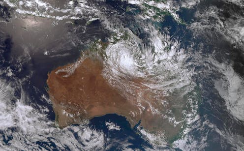
In 2023, almost a year’s worth of rain fell over ten days in parts of northwestern Australia, leading to catastrophic flooding in the town of Fitzroy Crossing and surrounds. The rainfall was linked to a tropical cyclone, but there were also lesser-known forces at work: huge, planet-scale oscillations called atmospheric waves which bring heavy rain to northern Australia.
While climate drivers such as El Niño and La Niña are becoming more familiar to many Australians, fewer understand the significant role played by atmospheric waves, which are like vast musical notes resonating around the globe. These waves can greatly influence rainfall and extreme weather events in Australia – and we don’t know yet whether they could grow more intense as the world warms.
In our latest research, we discovered how these waves affect Australia’s rainfall, and how they can help us make better weather forecasts. The research is published in the Journal of Climate.
What are atmospheric waves?
You can think of atmospheric waves as huge musical notes that travel through the atmosphere around the equator. Just like a musical note, an atmospheric wave has a frequency (a pitch, or how often it oscillates) and an amplitude (a volume or intensity).
Atmospheric waves can interact with each other to create complex melodies and harmonies in the atmosphere. They affect many aspects of the atmosphere, such as wind, humidity and pressure.
In the same way musical harmony can evoke emotions, certain combinations of atmospheric waves can lead to complex clusters of clouds that evoke extreme rain events.
Equatorial atmospheric waves were first discovered mathematically in 1966 by Japanese researcher Taroh Matsuno. By solving equations that describe the behaviour of the atmosphere near the equator, he found waves that could be categorised by frequency, structure, speed and direction of movement.
Later research found these waves exist in the real world – and they have been studied ever since.
Some of the most important waves are called Kelvin waves and equatorial Rossby waves. Kelvin waves are centred around the equator, propagate to the east, and take between 2.5 and 17 days to complete one oscillation.
On the other hand, equatorial Rossby waves are structured as a pair of swirls, one north of the equator and one to the south, which propagate to the west. They are also slower than Kelvin waves, taking between 9 and 72 days to complete an oscillation.
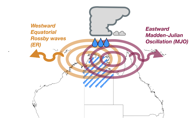
There are also two other kinds of equatorial fluctuations, discovered after Matsuno’s original work. These are the Madden–Julian Oscillation, which propagates eastward, and tropical depression-type waves, which propagate to the west. Both of these have their own frequencies and influences on the Australian atmosphere.
Impacts on Australian weather
We studied the relationship between these waves and rainfall in northern Australia from 1981 to 2018. We found the waves had a significant impact on rainfall during the southern summer (December–February) and autumn (March–May).
Equatorial Rossby waves that cross Australia may make heavy rainfall around 1.5 times as likely as normal, while tropical depression-type waves make it 1.3 times more likely.
When waves combine in certain ways, heavy rain events become even more likely.

For example, a combination of an equatorial Rossby wave and the Madden–Julian Oscillation can make heavy rain in northern Australia two to three times more likely. Similarly, if a tropical depression-type wave and an equatorial Rossby wave cross Australia at the same time, heavy rainfall could be twice as likely as usual.
Due to Australia’s vast landmass and local geography, the impacts of these waves are quite different across the continent. Regions such as the Kimberley, Cape York and the Top End experience the largest impact from these waves, increasing the chance of heavy rain by up to 3.3 times.
Meanwhile, the impacts of these waves on the eastern coast of Queensland and inland Queensland are not as great as in the other regions. However, the change in likelihood is still quite high: the waves can make heavy rain 1.4–2.2 times more likely than it would otherwise be.
What does the future look like?
We have shown that the activity of these “atmospheric melodies” is important and potentially provides room for improvement in weather models.
Currently, a good representation of these waves in weather models can improve forecasts up to two weeks ahead.
A better representation of these waves may improve future weather prediction in the tropics.
In addition, the impact of these waves in a warmer world is still a mystery. Recent research suggests some atmospheric waves, such as Kelvin and the Madden-Julian Oscillation, could become more intense, potentially with more organised cloud clusters and significant impacts on heavy rain events.
Fadhlil Rizki Muhammad receives funding from The University of Melbourne and ARC Centre of Excellence for Climate Extremes.
Andrew King receives funding from the ARC Centre of Excellence for 21st Century Weather and the National Environmental Science Program.
Claire Vincent receives funding from the ARC Centre of Excellence for Climate Extremes and the ARC Centre of Excellence for the Weather of the 21st Century
Sandro W. Lubis receives funding from U.S. Department of Energy Office of Science Biological and Environmental Research as part of Global and Regional Model Analysis program area. The Pacific Northwest National Laboratory (PNNL) is operated by Battelle for the U.S. Department of Energy under Contract DE-AC05-76RLO1830.
This article was originally published on The Conversation. Read the original article.


