The drive to Sydney can be long and boring, but by keeping an eye out for some of the much-loved landmarks, you can make the drive much more enjoyable, especially if you have kids in tow. Today, in the first of a two-part series, we shine the spotlight on the section of highway between the ACT border and Marulan, just north of Goulburn. Distances are approximate and measured from the ACT border.
Grand grasstrees (20.5km)
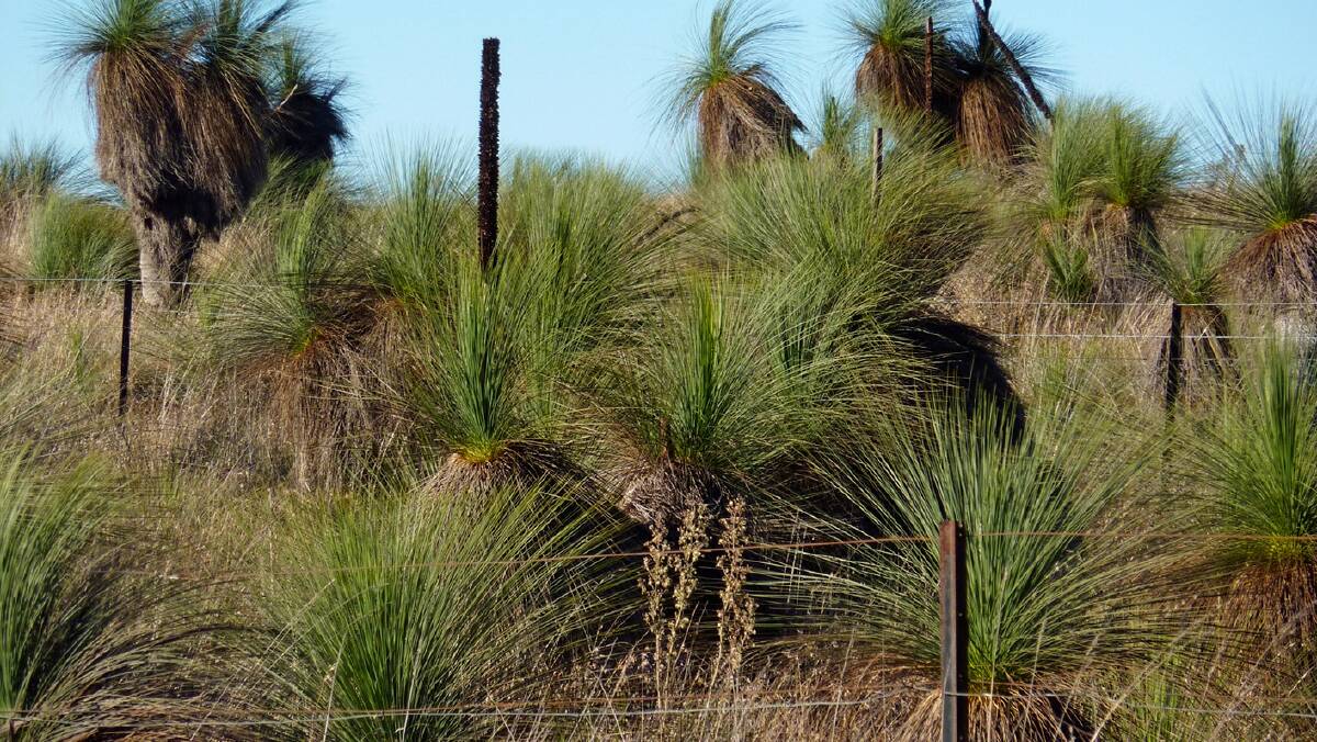
With the recent big wet resulting in Lake George finally living up to its name again, a stop at the Weereewaa (Aboriginal name for the lake) Lookout just before Gearys Gap is essential for that obligatory photo. However, just before you reach the lookout, if you look beyond the southbound lanes of the highway, you'll see a small forest of grass trees (Xanthorrhoea australis), some reportedly up to 1000 years old. Many of these were transplanted here from the Gearys Gap area during the duplication of the Federal Highway in the late 1990s.
Convict canal (36km)
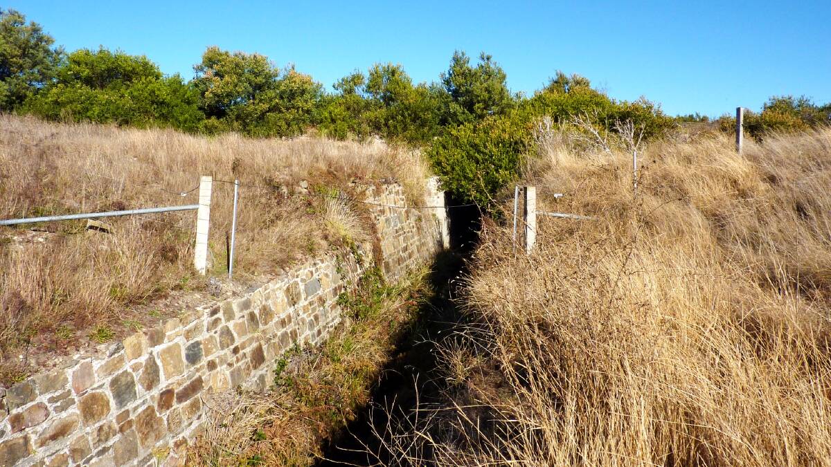
At the northern end of the lake, hidden under part of the old Federal Highway is a canal built by a chain-gang of convicts in the mid-1830s. The 50-metre-long and 4-metre-deep canal was the brainchild of early landholder Terence Aubrey Murray to channel fresh water from Lake George into the stagnant swamp on his property Ajamatong (Aboriginal word for marshy lagoon), also known as Murrays Lagoon. The canal proved to be a futile exercise because when it was completed, water from the swamp apparently flowed into the lake instead of in the reverse direction. Really!
Hidden homestead (40.5km)
Not far past the canal on the eastern side of highway (look out for the two silos) and hidden behind a stand of pine trees is Winderadeen Homestead, a stone mansion complete with suspension bridge over Collector Creek which was also part of the Murray estate. When the Ben Hall gang lay siege to Winderadeen in 1864, Murray apparently stuffed the windows with mattresses in the hope that they would absorb any bullets. Did it work? No, according to some reports, the gang simply walked through the front door instead.
Concealed chapel (55.5km )
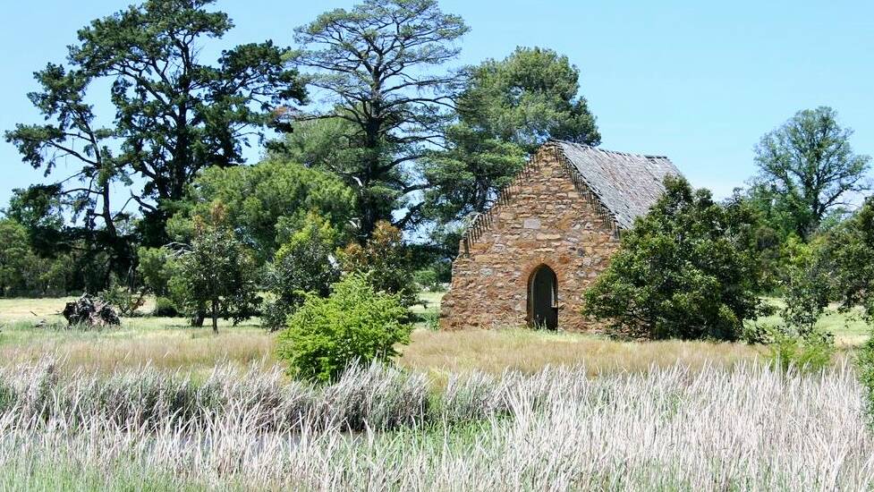
Behind trees on the eastern side of the highway are the ruins of an old church built in 1873 as the Anglican Church of St Michaels and All Angels, but today better knowns as "The Kirkdale Church", after the name of the property it stands on. In the late 1800s it doubled as a school where it is believed celebrated author Miles Franklin may have attended in 1890 as an 11-year-old after moving from Brindabella to "Stillwater", a nearby farm.
Pretty plant (63.5km)
About three kilometres before you reach the junction of the Hume Highway is a short section of road flanked by bright yellow signs with the words "No weed spraying endangered species". These are in place to alert the sometimes-over-zealous weed spraying road workers of the rare Hoary Sunray (Leucochrysum albicans) which grows here.
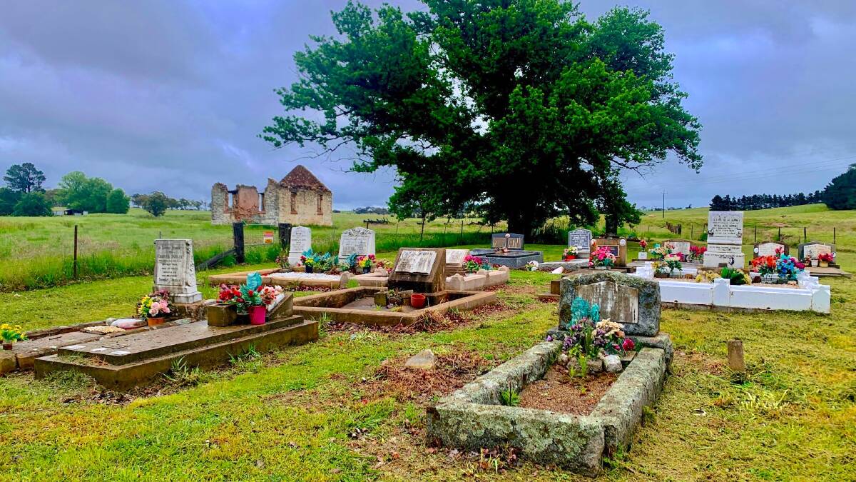
Rustic ruins (66.5km)
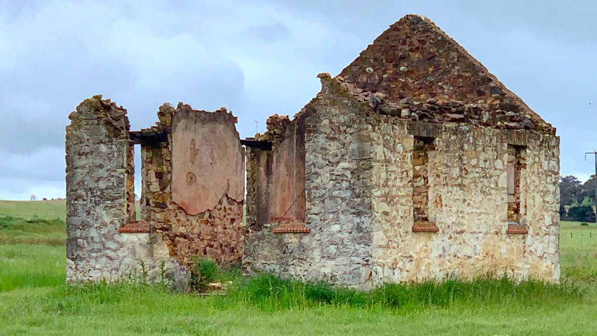
Just past the junction with Hume Highway at Yarra is a small well-kept graveyard and the ruins of St. Bartholomew's Church built by the primitive methodists in 1868. The church was later sold to the Anglicans and renamed St. Marys. Unfortunately, in April 1986 a bushfire swept through the area, totally gutting the historic building, which was thankfully empty at the time. If you drive down Barkers Lane (take care turning off the highway) for about 50 metres and drive down the gravel track to the left, you can pay your respects to the early pioneers buried in the cemetery. Note: the church ruins are on private property.
Mysterious murder (72.5km)
As you cross Run O Waters creek, spare a thought for ex-convict "Black Francis" who occasionally assisted the chief flogger at a nearby penal camp wielding the Cat o' Nine Tails. It seems that some of his former cell mates may not have been too happy with his turncoat role, for he was found not far from this creek crossing mysteriously murdered.
Terrific tower (78km)
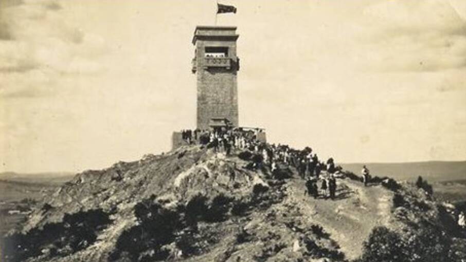
When driving along the Goulburn bypass (don't forget to watch out for those flashing blue lights) if you peer up to the left, you can't miss the 20-metre high stone castellation on Rocky Hill. The lookout gallery at the top of the tower which was built in 1925 as a war memorial also gives unsurpassed views of Goulburn and surrounds.
Convict cells (89km)
Without doubt, the best-preserved penal road camp in southern NSW is located near the corner of the Hume Highway and Towrang Road (park in the gravel area on Sydney side of the intersections and climb over the stile). While little remains of the stockade itself which housed convicts (including Black Francis) between 1833 and 1843, you can still see mounds of earth that mark the location of their holding cells. The kids will love checking-out the powder magazine (don't get locked-in!) which is set in the bank of the river.
Beautiful bridge (89.5km)
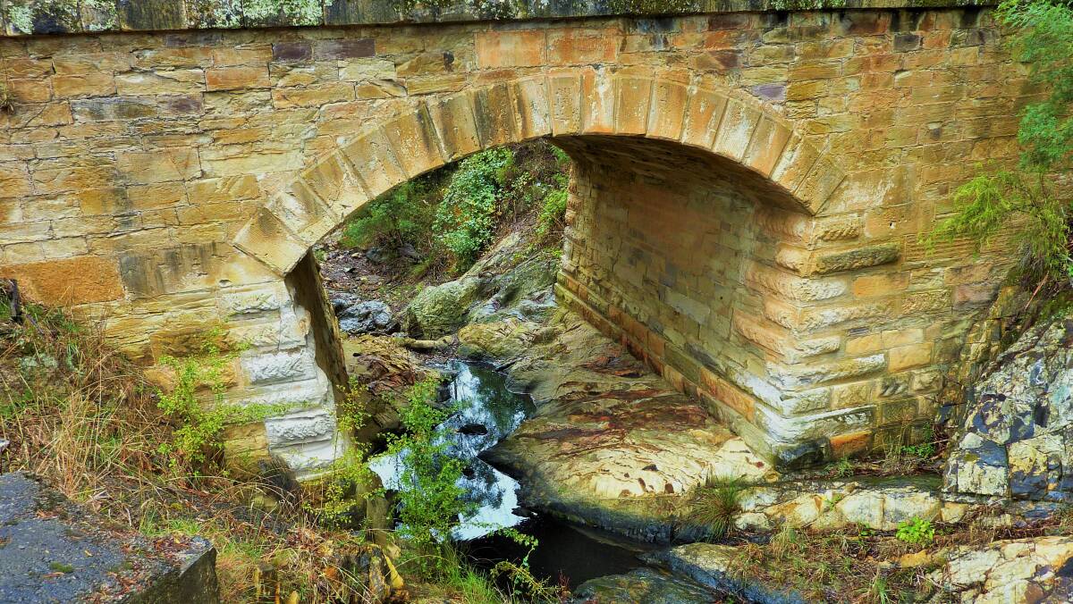
Across the highway from the stockades (don't walk across, it's too dangerous) at the Derrick VC Rest Area is an 1839 masonry arch bridge and several stone culverts built by the gang at Towrang Stockades. They don't make bridges like they used to.
- CONTACT TIM: Email: tym@iinet.net.au or Twitter: @TimYowie or write c/- The Canberra Times, PO Box 186, Fyshwick, ACT, 2609
An eely impressive discovery
Last week's exposé on Intermittently Closed and Open Lakes and Lagoons (ICOLLS) on the south coast prompted David Salt of Ainslie to share a recent "amazing experience" at his favourite ICOLL - Willinga Lake.
Like many of the 70 (yes, that many!) ICOLLS along the NSW coast, Willinga Lake, located just north of Bawley Point, is usually landlocked, but heavy rain before Christmas forced a channel through the sand dunes, re-connecting it to the ocean.
Shortly after it opened, while walking along the edge of the lake's entrance on low tide David reports he and his wife, Yvette, "noticed something squirming in the water at the edge of the channel".
"The lake water, at this low point, was still brown and very stinky, so it's likely the lake had only just opened," explains David who, when he and Yvette cautiously approached the channel couldn't believe their eyes.
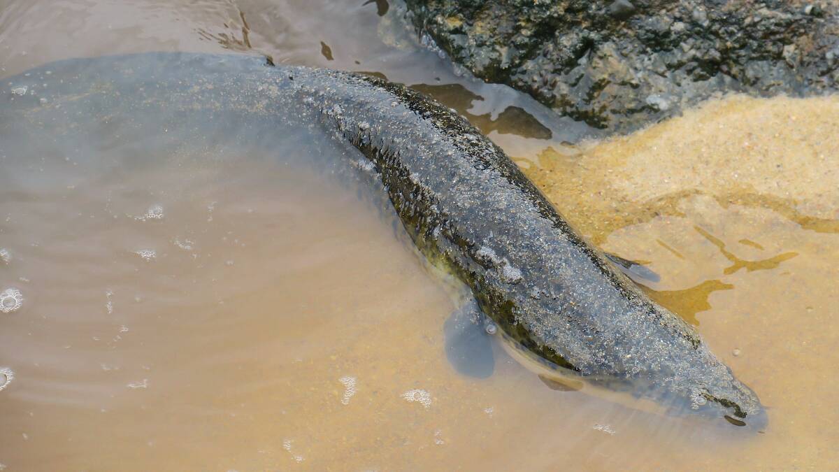
"There were dozens of giant eels, writhing back and forth, looking quite upset" he reveals, adding "I assume they were distressed by the sudden opening of the lake and a rapid change of salinity with the ocean water flushing in."
They weren't small either. "Each eel was over a metre long and, at the thickest, a hand span in width at the head."
A few days later, after several high tides had "flushed all the stinky, brown water out", David returned to the lake.
This time David couldn't find any eels near the entrance, and so with the lake water much clearer, donned snorkel, mask, and flippers.
"I snorkelled all over the lake and never spotted any more eels, either dead, or alive" reports David who asks "so, where did they go?"
I suspect David and his wife witnessed a bed of Longfin eels (Anguilla reinhardtii) which move from marine to fresh waters as juveniles and return to the sea as adults. If you've witnessed something similar, both David and I would love to know.
WHERE IN THE SNOWIES?
Rating: Medium
Cryptic Clue: What a "cracking" photo.
Last week: Congratulations to David Evans of Fadden who was the first to correctly identify last week's photo as a postman on horseback outside the old Nelligen Post Office opposite to where the punt used to cross the Clyde River.
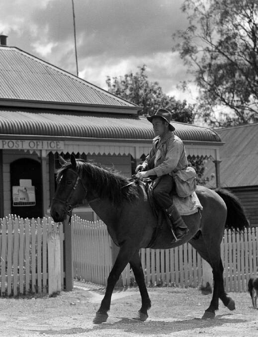
"I remember one night not getting there in time for the last night crossing and having sleep in the car until morning when it started again", recalls David who just beat Nev of Calwell, Sarah from Monash, and Neil Clarke of Gordon to the prize. The photo is courtesy of the National Archives of Australia and dates from 1948.
How to enter: Email your guess along with your name and suburb to tym@iinet.net.au. The first correct email sent after 10am, Saturday January 15, 2022, wins a double pass to Dendy, the Home of Quality Cinema.
SPOTTED
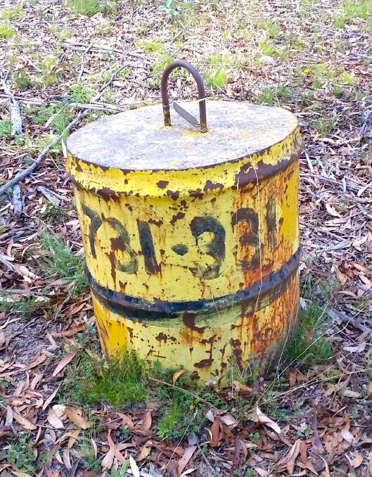
On a recent trek to Mt Foxlow near Captains Flat, David Wardle of Mawson stumbled upon "a large concrete weight" in bush near the top of the mountain.
"Curiously, it had 731lbs painted on it" reveals David, adding, "the disc attached to it also states that it was made in 1984 which was well after weights and measures had gone metric so why was the main measurement in pounds?"
David wonders its purpose. "Perhaps it was for helicopter pilot training? Someone must know.
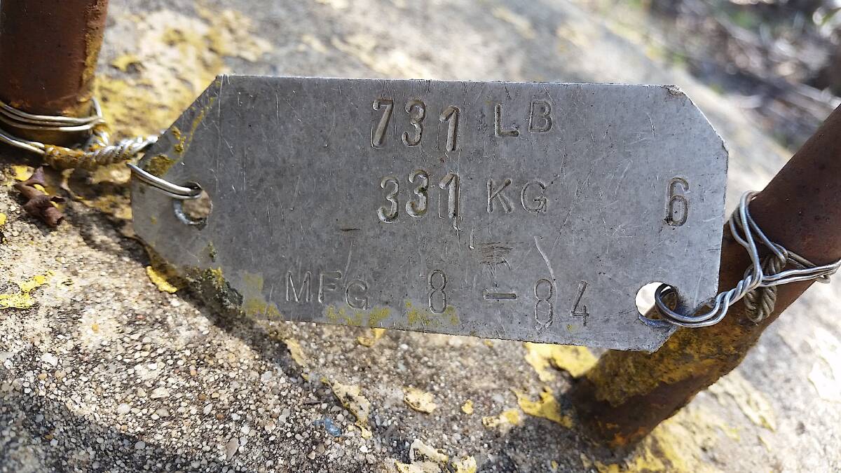
"The mountain itself has a sturdy old stone trig point and a metal frame with steps which was presumably a rudimentary fire observation post," adds David.