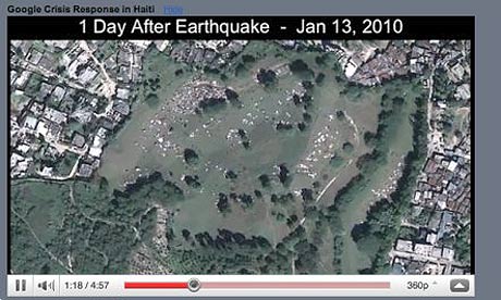
If a picture tells a thousand words, there are few images that explain the impact of the Haitian earthquake disaster better than the satellite view of the Pétionville golf course.
Within days of the disaster, Haiti's only golf course – and a rare pocket of wealth in the poorest country in the Western hemisphere – had been filled with makeshift tents that became home to an estimated 55,000 people. The transformation of Pétionville was documented thoroughly on Google Maps, which uses satellite imagery provided by GeoEye.
The day after the disaster, GeoEye's planes captured the state of the course – which already showed people starting to set up makeshift homes on the camp. Google followed up with higher resolution imagery in the weeks after the disaster; all these layers can be viewed on Google Earth's "time" layer, which scrolls back from today to before the earthquake.
Google sent a small team to work in Haiti in the aftermath of the disaster under the auspices of its charitable wing, Google.org. They helped bring in hardware to get Haiti's internet infrastructure back online, and created a landing page on Google.org for news and resources on the relief effort. But the system of organising information to help track down lost friends and relatives was split between 14 different sites.
"In the aftermath of 9/11, the person-finding tool was a wall of faces," said Prem Ramaswami, who led the Crisis Response project. "After Katrina, there was a recognition of the need to standardise the way to report and send out alerts for missing people, so after Haiti we developed PFIF (People Finder Interchange Format)."
From that database format, volunteers from Google developed a simple, unbranded person finder tool in three days – and the public and relief workers built up 50,000 records on missing people.
One month later and the same tool was used after the earthquake in Chile that killed more than 500 people, and in the first 12 hours the web-based app had seen 1m page views. After one day, 77,000 records were posted and 64% of those had supplemental notes about sightings or advice posted by other members of the public.
Crowdsourcing site Ushahidi - whose founder Ory Okolloh was recently hired by Google to manage its Africa policy – was also active in Haiti, setting up the shortcode 4636, in collaboration with several other organisations, so that people could text for help. More than 150 people's lives were saved through the system after texting details of their location. Despite its poverty, Haiti has mobile penetration of around 35%, and some Haitians carry two handsets because the country's rival networks aren't well integrated, Ramaswami explained.
Another Google database project was Resource Finder, which listed and located different types of medical centre on a map. Oxfam also created a Google Map to document their work in Port-au-Prince, with films documenting their work trying to prevent more outbreaks of cholera, photos of their distribution centres and blog posts explaining resettlement.
"The 82nd Airborne was using Google Maps because it's a tool they know and understand," said Ramaswami. "We just wanted to find something Google could do, to use its strengths to help the NGOs. Ushahidi, Doctors Without Borders and lots of other organisations were doing amazing things on the ground, and we wanted to use engineering to solve problems."


