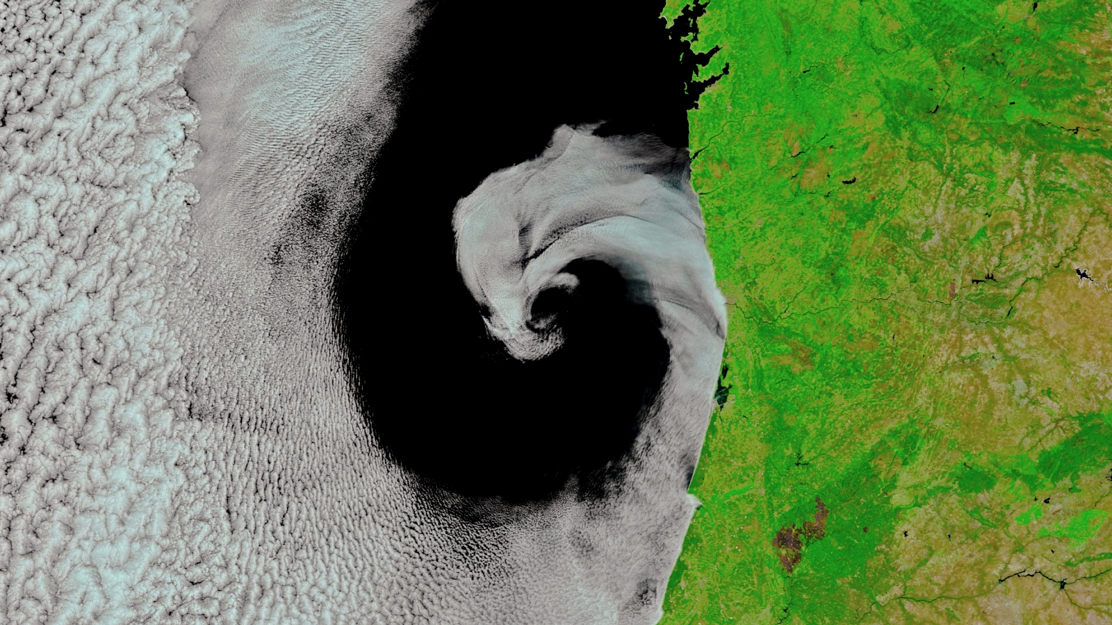
Where is it? The west coast of the Iberian Peninsula (Spain and Portugal).
What's in the photo? A spiraling cloud front hugging the coastline.
What took the photo? NASA's Terra satellite.
When was it taken? July 16, 2017.
This striking photo shows an unusual cloud spiral nestled perfectly along the west coast of the Iberian Peninsula in 2017.
The spiral consists of moist, cloudy air from the sea that's been swirled together with clear, dry air from the land by a phenomenon known as cyclonic rotation — the same mechanism that is responsible for generating tropical storms such as hurricanes, typhoons and cyclones, according to NASA's Earth Observatory.
However, in this case, the rotation was much slower and weaker than the rotation during tropical storms, so the cloudy and dry air did not fully mix together, which prevented a proper vortex from forming. This also stopped any clouds from passing over the land. (The image has been edited slightly to include more infrared light, in order to accentuate the difference between the land and cloud.)
"Precisely what caused this [unusual] mid-latitude rotation remains somewhat of a mystery," Stephen Jospeh Munchak, a meteorologist at NASA's Mesoscale Atmospheric Processes Laboratory told NASA's Earth Observatory. However, it could have been caused by an eddy — a temporary, swirling current of water that extends deep below the ocean's surface, he added.
An extreme heat wave that swept across Southern Europe in July 2017 also created an usually large temperature difference between the cloudy, sea air and the dry, land air. This may have further prevented the two fronts from mixing, helping to create the stunning spiral shape. When this photo was taken, temperatures in Spain and Portugal were above 104 degrees Fahrenheit (40 degrees Celsius), according to NASA's Earth Observatory.
Related: 12 amazing images of Earth from space
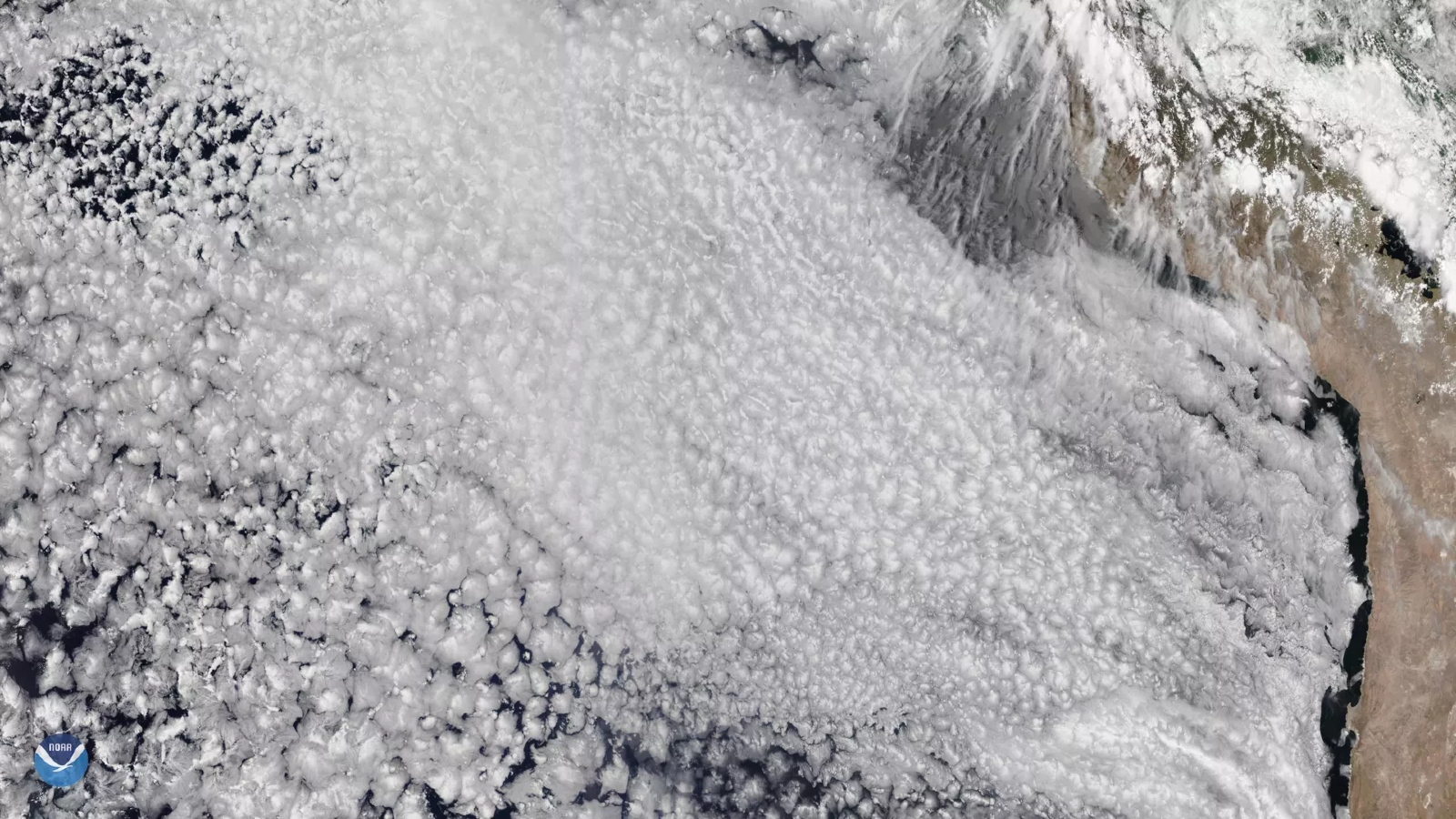
The clouds in the spiral are marine stratocumulus clouds — common low-lying clouds that usually stay below 6,000 feet (1,830 meters) and can cover up to 6.5% of Earth's surface at any one time, according to the National Oceanic and Atmospheric Administration (NOAA).
Interestingly, marine stratocumulus clouds normally only appear along the western coasts of Earth's landmasses, according to NOAA. This is because they form when cold water from the deep sea is brought to the surface by Earth's spin — also known as the Coriolis effect — which cools the air above and enables water vapor to condense into clouds. Along eastern coastlines, the Coriolis effect does not push cold water toward the coast, which means it does not rise toward the surface.
The rotating clouds in the image stretched for hundreds of miles and likely persisted for several days. However, it is unlikely that they released any precipitation, according to NASA's Earth Observatory.
Similar cloud cyclones have appeared off the Iberian coast and the western coast of Morocco in the past but they are not normally as defined as the spiral in this photo, according to NASA's Earth Observatory.