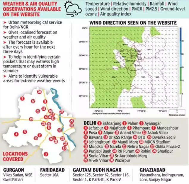
NEW DELHI: Now, residents of Delhi-NCR stepping out of their homes and offices will have advance warning about vulnerable areas that could see extreme weather events and are best avoided.
The IMD’s urban meteorological service will give localised forecasts of 43 stations across the region after every hour on temperature, relative humidity, rainfall, wind speed, wind direction, PM10 and PM2.5 levels, air quality index (AQI) and ground ozone.

Thus, this summer, the service will help residents identify certain pockets with high temperatures or others that could witness a dust storm.
According to Met officials, the weather and air quality parameters vary from place to place.
“Highly urbanised areas witness a higher temperature. For instance, the distance between Connaught Place and Lodhi Road is a few kilometres, but the temperature varies due to urbanisation and green cover. We have developed a high-resolution (3km) mesoscale weather research and forecasting modelling system to ensure that no extreme weather event goes undetected in any part of the city,” said RK Jenamani, senior scientist, IMD.
He added that while the website https://mausam.imd.gov.in/Delhi/ was made recently operational, some advanced features are still being added to it. A person can check hourly forecasts of localised weather and air quality for the next three days.
For this service, IMD has collected data from the Central Pollution Control Board, Delhi Pollution Control Committee, Haryana State Pollution Control Board, Uttar Pradesh Pollution Control Board and the Indian Institute of Tropical Meteorology. Of the total 43 stations, 30 are in Delhi and the remaining in NCR districts.
“May and June are important months as the maximum temperature remains high. On the basis of the IMD’s forecast, people can avoid stepping out or take other precautionary measures. Similarly, the service will help the agencies concerned, like the power department and the Delhi Jal Board,” said Jenamani.
Apart from localised data, the service gives district-wise prediction and warning. The Met department said it is digitalising the data on the GIS platform for providing impact-based ward-wise weather forecasts in the future.
“We are integrating all data so that people can know the impact of heat waves, dust storms, cold waves and heavy rainfall at the ward level. We will issue advisories accordingly to avoid urban pockets in case of an extreme weather event,” said another Met official.


