Continents and oceans have scientific definitions that underpin international law. The idea of dividing the world into geographical zones is ancient. Sovereignty and influence over natural resources is at the heart of most global divisions.
A peaceful transition away from fossil fuels will require new global agreements on how to manage mineral resources in the deep ocean as well as those associated with continents. Technology and modern global politics are creating new challenges.
Scientific, cultural and legal definitions of continental and oceanic regions continue to evolve. During the past decade, we surveyed, sampled and defined the hidden continent of Zealandia.
Intense global media coverage of our work revealed deep-seated arguments about how we define continents and govern the ocean.
This is understandable, given knowledge about the Earth’s tectonic plates was formed during a period when we also discovered fossil fuel reserves offshore from continental shelves.
Most technologies developed last century depend on fossil fuels. Together with fishing interests, this drove a political desire to define nations’ sovereignty over submarine continental extensions.
But the transition to renewable energy is now pushing in a new direction. Critical minerals such as nickel, copper, cobalt and rare earth elements will become more sought after than oil in the coming decades.
These can all be found in large quantities in the deep ocean, far from continental shelves. Offshore reserves may be much larger than those found onshore. But there is currently no agreed framework for sovereignty over the deep ocean.
As the ocean covers 70% of our planet, we need a workable agreement on its custodianship.
Difference between continental and oceanic crust
The surface of Earth is broken into large rigid plates that diverge at mid-ocean ridges and converge at ocean trenches or mountain ranges. The interior of Earth, the mantle, is solid rock. But it is hot enough to creep slowly at a few centimetres per year, allowing plates to move.
The scientific theory of plate tectonics became widely accepted during the 1960s.
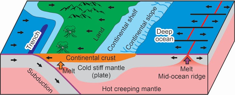
A plate is about 100 kilometres thick and has a “crust” embedded in the top, created by melting and other chemical reactions. New oceanic crust is formed at mid-ocean ridges by melting the mantle, leading to a uniform crustal thickness.
These oceanic plates are consumed back into the mantle at subduction zones, where we find deep ocean trenches and volcanoes, such as along the Pacific Ring of Fire. The oldest oceanic plates on Earth date back about 200 million years.
In contrast, the crust of continents lies under shallow oceans and land. It is highly variable in composition and age. Some can be nearly as old as the solar system itself, about 4.6 billion years.
Continental crust is generally higher in silica, which makes it less dense. This low density makes continents too buoyant to be pulled back into the mantle and they remain floating near the surface. If a continent is caught in a convergent zone between plates, then the crust can become very thick, pushing up mountain ranges such as the Himalayan belt.
Definition of a continent
Physical boundaries such as rivers, oceans or mountain ranges have long served as geographical borders.
Physical science and human culture are intertwined in most historical attempts to subdivide Earth. About 2,000 years ago, building on earlier ideas, Roman philosopher Pliny the Elder subdivided the world into Europe, Asia and Africa.
The word “continent” comes from the Latin terra continens, which means continuous land. From the 1500s to 1700s, European explorers mapped the world and defined continents of North America, South America and Australia.
The existence of Antarctica was confirmed during the 1800s. The last continent to be discovered was Zealandia, because it is 94% under water. Zealandia was surveyed during the 1900s but was not officially confirmed as a continent until 2017.
The marine realm was lawless for most of history. However, after the second world war, many countries claimed rights over fish and mineral resources in the ocean. This led to the United Nations Convention on the Law of the Sea (UNCLOS), which came into force during the 1960s.
UNCLOS was renegotiated to reflect scientific and technological advances, and the latest version came into force in 1994. It has been ratified by 170 states, but this does not include the US.
Of particular significance is the UNCLOS Convention on the Continental Shelf, and Article 76, which defines legal criteria for how a “continental shelf” is defined, based on scientific concepts and measurable physical criteria. It allows sovereignty of nations to be extended to near the base of the continental slope.
The modern scientific definition of a continent has four criteria:
Elevation (water depth)
geology of the crust
geophysical properties of the crust
and geometry (continuity, seabed slope).
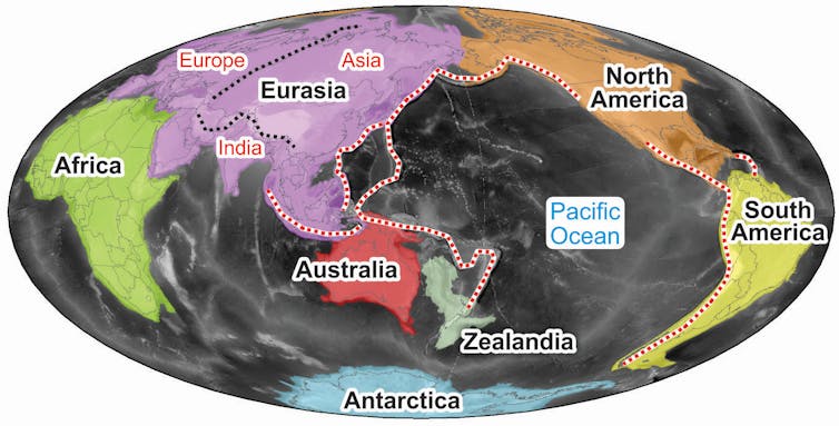
According to this definition, Earth has seven continents: Eurasia, Africa, North America, South America, Antarctica, Australia and Zealandia.
Europe amalgamated with Asia more than 200 million years ago, and India was added to Eurasia about 50 million years ago.
Mining the deep sea
Deep-sea exploration and mining technology now make it possible to harvest mineral deposits from the seafloor.
The International Seabed Authority (ISA) was formed in 1994 as part of UNCLOS to govern exploitation of the deep ocean and regulate environmental concerns.
The ISA aims to finalise a deep-sea “mining code” by July next year.
However, a coalition of 32 countries has called for a moratorium on deep-sea mining in international waters. Global consensus on rules and compliance remains elusive.
Several countries are interested in starting mining operations within their exclusive economic zones and there have been applications for permits to explore deep-sea mining in international waters.
The world needs resources to transition away from fossil fuels to renewable energy. Resources are abundant in the deep ocean, but environmental concerns remain. Good governance is going to be essential for an optimal outcome. We urgently need consensus and agreement on how to proceed.
Rupert Sutherland has received research funding from the New Zealand Government.
This article was originally published on The Conversation. Read the original article.


