Blizzard warnings are in effect for 11 million people from coastal Virginia to eastern Maine as a historic winter storm is set to slam the Mid-Atlantic and Northeast beginning Friday.
Why it matters: The storm will bring hazards ranging from zero visibility amid hurricane force wind gusts and heavy snow, to coastal flooding that will erode vulnerable beaches and threaten property from the Jersey shore to coastal Massachusetts.
- Over 6,000 flights for Friday and Saturday have been canceled as the region braces itself for the impact.
The big picture: The storm is expected to rapidly intensify as it moves from the Carolinas on Friday evening to a position south-southeast of Cape Cod on Saturday. A total of 75 million people were under some form of winter weather alerts as of Friday afternoon.
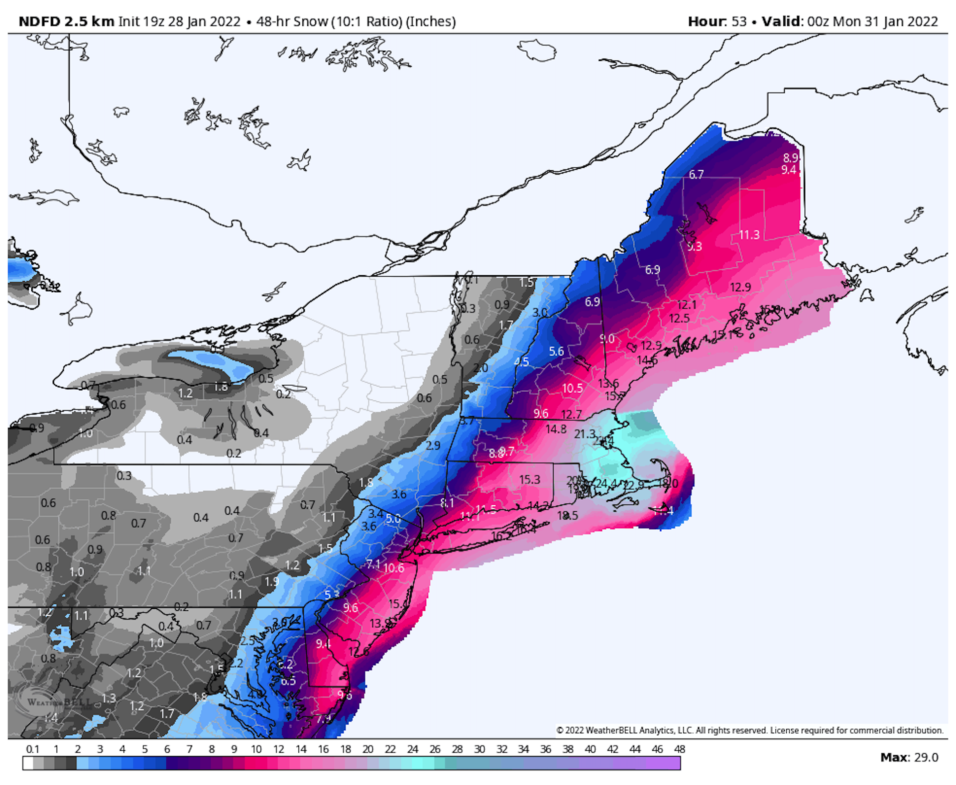
- As the storm moves north, it will bring a swath of extremely heavy snowfall and strong winds, with one to two feet of snow or more forecast to fall from coastal Virginia to eastern Maine.
- The highest snow totals are expected in Massachusetts, where Boston is predicted to see at least two feet, with up to 30 inches in parts of the metro area, according to the National Weather Service (NWS). This event may become the biggest snowstorm on record in Boston.
[1/2] [Friday 5PM] A major winter storm will unfold overnight tonight into tomorrow with #blizzard conditions for eastern MA & RI. Snowfall rates could be 2-4"/hour at times with whiteout conditions and considerable #snow drifts. Travel could be near impossible. #MAwx #RIwx #CTwx pic.twitter.com/viDp1Mi3D8
— NWS Boston (@NWSBoston) January 28, 2022
- The low pressure area responsible for this blizzard will undergo a process known as bombogenesis Friday into Saturday, and it's therefore referred to as a bomb cyclone. This is due to the rapid drop in its minimum central air pressure, which will exceed the bomb cyclone definition of plummeting at least 24 millibars in 24 hours.
- According to the National Weather Service, the pressure plunge could be as fast as 40 millibars in that time frame, a feat meteorologists called "explosive" in a forecast discussion Friday morning. In general, the lower the pressure, the stronger the storm.
The latest: The governors of Rhode Island, New Jersey and New York declared states of emergency Friday. Maryland Gov. Larry Hogan also declared a state of emergency Friday and mobilized members of the Maryland National Guard ahead of the storm.
- Massachusetts Governor Charlie Baker asked residents to stay home Friday night through Saturday. "Two to four inches per hour is basically whiteout conditions," he said, referring to peak snowfall rates.
Threat level: Coastal areas will bear the brunt of this storm, though in New England, some of the most prolific snow bands could move well inland, based on computer model projections.
- The NWS forecast office in Boston is warning of wind gusts along the coast that could exceed hurricane force of 74 mph, knocking out power when temperatures will be in the low teens.
- A combination of the frigid temperatures in the low teens, record warm ocean temperatures for this time of year and strong atmospheric lift may produce thundersnow in the heaviest snow bands.
- Warmer than average ocean temperatures off the New England coast will aid in intensifying the storm and adding more moisture to it, helping it produce extremely heavy snowfall over land.
- In eastern Massachusetts in particular, "extreme" impacts are likely, the NWS warns.
- The forecast snowfall totals would make this the biggest snowstorm the region has seen since 2018, and the first blizzard warnings to be issued in the region since then.
Good reminder from our friends in Mount Holly on what exactly constitutes a blizzard! ❄️ https://t.co/FWilDXdlJ8
— NWS Boston (@NWSBoston) January 28, 2022
- Some spots could break longer-term records. For example, Boston has not seen a snowstorm deliver more than two feet of snow during the month of January, and if amounts exceed 28 inches, which is possible, it would become the city's biggest snow event on record.
- In New York City, amounts are expected to be lower, with between 8 and 12 inches. The storm's fickle track makes it difficult to pin down snowfall amounts there, the NWS stated.
Our thought bubble: Everything about this storm -- its rapid intensification, track over unusually mild ocean waters and extremely cold air in place over land -- makes it a prime candidate for producing record snow totals.
Context: Many of the Mid-Atlantic and Northeast's biggest snowstorms on record have occurred since 2000, in line with climate change-related trends toward more frequent and severe heavy precipitation events.
- Five of Boston‘s top 10 snowstorms have occurred since 2003, and eight of its top 10 since 1978.
- Baltimore has seen seven out of its top 10 biggest snowstorms since 1979, and four of its top five took place post-1996.
- Philadelphia‘s top three snowstorms have taken place since 1996.
- In New York City, seven of its top nine biggest snowstorms have occurred since 1996, with six of them since 2003. Three of its top five have occurred since 2006.