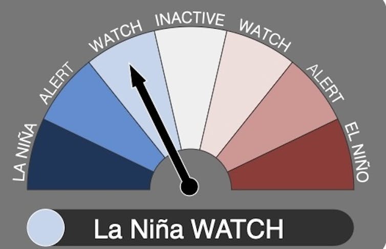
Meteorologists are again predicting a possible La Niña this summer, which means Australia may face wetter and cooler conditions than normal.
It would be the fourth La Niña in Australia in five years, and highlights the need for Australians to prepare for what may be an extreme weather season.
Typically, a La Niña or its counterpart, El Niño, signals its arrival earlier in the year. Signs of this potential La Niña are emerging fairly late. That’s where new research by my colleagues and I may help in future.
La Niña and El Niño explained
La Niña and its opposite phase, El Niño, are created by changes in ocean temperatures in the Pacific Ocean’s equatorial region. Together, the two phenomena are known as the El Niño Southern Oscillation.
The oscillation is said to be in the positive phase during an El Niño and the negative phase during a La Niña. When sitting between the two, the cycle is in neutral phase.
Earlier this month, the World Meteorological Organization said there was a 60% chance of La Niña conditions emerging by year’s end.
In the United States, the National Oceanic and Atmospheric Administration put the likelihood at 71%. Australia’s Bureau of Meteorology is in “watch” mode, predicting a 50% chance of a La Niña weather pattern forming later this year.
La Niña occurs when strengthening winds change currents on the ocean surface, pulling cool water up from the deep.
The winds also cause warm surface waters in the western Pacific and north of Australia, bringing increased rainfall and clouds. This usually means above-average rainfall and cooler temperatures for Australia, particularly in the east and north.
Conversely, an El Niño weather pattern generally brings hotter temperatures across Australia, and less rainfall in the east and north.

Paths of destruction
La Niña or El Niño events can cause devastation around the world.
The El Niño in 2015–16, for example, caused crops to fail and affected the food security and nutrition of almost 60 million people globally.
In Australia, El Niño events can bring increased risk of drought, bushfires and heatwaves, and water shortages.
Meanwhile, rainfall associated with La Niña conditions can lead to greater crop yield. But particularly heavy rainfall can wash crops away. It also heightens flood risks for some communities.
These far-reaching impacts mean it’s essential to plan ahead when a La Niña or El Niño is on the cards. But predicting these events has always been tricky.
Both types of events usually develop in the Southern Hemisphere autumn, peak in late spring or summer, and weaken by the next autumn. But it’s now late spring without a clear La Niña declaration. Why the delay?
Climate change is one factor. The Bureau of Meteorology says as oceans absorb heat from global warming, it’s harder to spot the specific warming patterns linked to La Niña.
The sheer complexity of the ocean-atmosphere system adds to the difficulty. The computer models used to predict El Niño and La Niña are improving all the time. But scientists still need more information on deep ocean processes, and how winds affect the oscillation.
Predictions are hardest during the Southern Hemisphere’s autumn. That’s because the cycle then is very susceptible to change – teetering at a point where either a La Niña or El Niño could develop.
That’s why the earliest an El Niño or La Niña can be predicted is usually around May or June.
But new research offers a way to predict the events much earlier – and start preparing if necessary.
Better, earlier forecasts
The study, which I led, assessed the likelihood of La Niña or El Niño events occurring in succession – either in the eastern or central region of the Pacific Ocean.
This distinction is important. For Australia, El Niño and La Niña events peaking in the Central Pacific, close to our continent, have greater impacts here compared to those peaking in the east, closer to South America.
We analysed weather observations, and the sequence of past El Niño and La Niña events, over the past 150 years. We also examined climate models for future changes in transitions between El Niño and La Niña events.
From this, we determined the likelihood of an El Niño or La Niña occurring in two consecutive years.
We found most El Niño events are followed by neutral conditions the next year (with a likelihood of 37–56%).
But La Niña behaves differently. In 40% of cases, a Central Pacific El Niño could follow an Eastern Pacific La Niña. And there is a 28% chance of two consecutive La Niña events in the Central Pacific.
These results allow for more advanced predictions. By identifying patterns in this way, the odds of an El Niño or La Niña can be predicted up to a year in advance.

Looking ahead
So, what does our research suggest for Australia? Will a La Niña develop here this year?
From September last year, Australia experienced a strong Eastern Pacific El Niño. So our findings suggest there is only a 17% chance of La Niña this year.
If the La Niña arrives, it will likely peak in the Central Pacific, potentially affecting Australia’s rainfall. But overall, any La Niña that develops this late is likely to be weak and relatively short-lived.
Our research also found that as climate change accelerates, the El Niño Southern Oscillation is likely to shift. For example, the odds of two consecutive El Niños peaking in the central Pacific region will likely increase. And we can expect fewer calm, neutral years between events.
We hope our research enables more accurate, long-range forecasts, giving communities additional time to plan and prepare.
Mandy Freund receives funding from the ARC Centre of Excellence for 21st Century Weather
This article was originally published on The Conversation. Read the original article.


