More than 300,000 homes and businesses are without power and residents are bracing for heavy rain and flooding after ex-Cyclone Alfred made landfall on Saturday night.
The system arrived on Australia’s mainland coast at 9pm on Saturday, local time, crossing between Brisbane and Maroochydore, according to the Bureau of Meteorology.
Earlier, the cyclone had been downgraded to a tropical low. It is now a weak low and moving inland.
Overnight, southeast Queensland and northeast NSW were battered by heavy winds. Very strong, gusty winds struck parts of Brisbane and surrounds, including gusts of 104 kilometres an hour at Redcliffe.
Heavy rain and possible flash flooding is possible on Sunday and weather warnings are current for large parts of southeast Queensland and northeast New South Wales.
The bureau predicts six-hourly rainfall totals between 80 and 130 millimetres on Saturday night and Sunday, and 24-hour totals between 120 and 200 millimetres.
Parts of the Northern Rivers in NSW have flooded and the region remains on high alert.
In short: the danger is not over. Residents in affected areas should remain cautious and heed official advice, to keep themselves safe.
High alert for heavy rain
Intense rain bands are forming between converging (or colliding) winds: warm, moist winds from the northeast, and southeast winds from the Coral Sea. As the winds converge, they push saturated air into cooler parts of the atmosphere where it condenses and may fall as torrential rain.
These rain bands can be very slow-moving, sometimes sitting almost stationary for hours. This means they can dump huge amounts of water.
That’s what we need to watch for now. If a slow-moving rain band forms over a catchment area, it could lead to dangerous flash flooding.
Northern NSW has already been hit by devastating flooding in recent years, most recently in February 2022. Many of its settlements, including Lismore, are along or close to major river courses. Residents are understandably anxious about what the next few days of rain may bring.
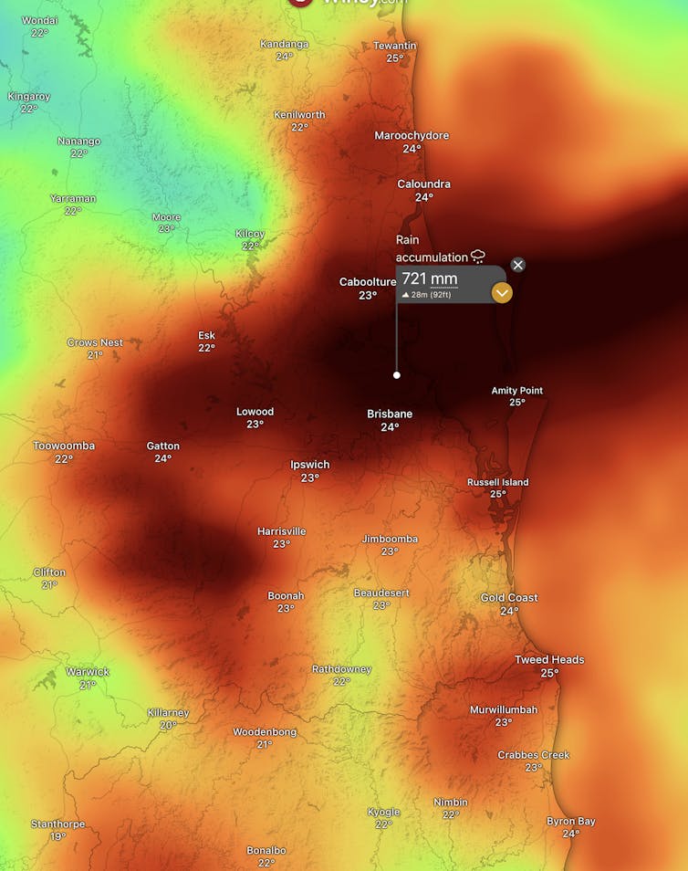
Heavy rainfall in the Brisbane catchments remains a major concern. In Brisbane, some 20,000 properties have been warned of impacts ranging from minor inundation in yards to significant flooding inside homes. Areas most at risk include Nudgee Beach, Brighton, Windsor, Ashgrove, Morningside and Rocklea.
The below flood maps were produced by Brisbane City Council and show the areas at risk.
Watching the winds and beach erosion
While the cyclonic winds have dissipated, there’s a risk that thunderstorms will drag down stronger winds from higher in the atmosphere. Thunderstorm activity is possible from Brisbane’s south down to northern NSW. Some areas may experience damaging wind gusts as rain squalls come through.
Coastal erosion will continue for a while yet. Cyclone Alfred released a lot of energy into the ocean and that will take a while to release as damaging swells.
Swells remain high from the northern Sunshine Coast down to northern NSW, and beaches remain closed.
Beaches have been pummelled over the past few days, eating into the sand and creating cliff faces in dunes. Much work will be needed over the next few weeks and months to restore that sand.
Widespread power outages
According to the ABC, more than 300,000 homes were without power on Sunday across southeast Queensland and northern NSW.
Emergency officials have warned residents not to approach downed powerlines because they may be live.
What next?
The below map released by the bureau on Saturday predicts the weather system’s future movement and intensity. The grey zone indicates the range of tracks the centre of the ex-cyclone centre may follow.
It shows the system tracking west, to near the town of Dalby, then heading to the southwest.
This movement will take moisture with it, bringing rain to some inland catchments from Saturday evening and into Sunday.
The rainfall predictions are dependent on the movement and position of this erratic weather system. This cyclone has already tricked scientists a few times over the past fortnight. We will continue to watch it closely.
Steve Turton has previously received funding from the federal government.
This article was originally published on The Conversation. Read the original article.