Because architectural facades are noticed first, the beauty of urban design is often overlooked. But thanks to the World Urban Planning Instagram account, we can see a city’s framework in full view.
The page features stunning aerial images of Copacabana's picturesque coastlines, distinct and innovative infrastructures in Saudi Arabia, and lush greenery in a forested suburb in the Netherlands, among others.
We've put together some photos that stood out. Scroll through this list and see the world in a different light, literally.
#1 Sapporo, Hokkaido, Japan
A well cared tree row covers a huge area just north of Sapporo city. The urban forest surround the community, and connect two green areas together. Such urban forest contribute to a more walkable, livable and sustainable city (and has contributed to the identity of the place). Not only do they help in the removal of pollutants from air and water, but also contribute to more green and vibrant neighborhoods. Streets become more enjoyable to walk along. Urban green space enhance the quality of our daily lives and can return millions of dollars annually in health benefits.
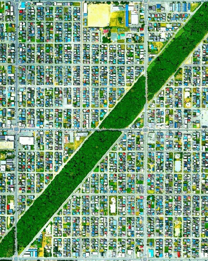
Image credits: worldurbanplanning
#2 Palmanova, Udine Province, Italy
Palmanova was built in 1593 during the late Renaissance period. It is one of the many old star forts from this period. This 9 pointed star fort, designed by Vincenzo Scamozzi, is an attempt to follow the ideals of an utopian city. In 1960 the fort was declared to be of national treasure and became a national monument, and in 2017 it was included in UNESCO’s World Heritage Site list.
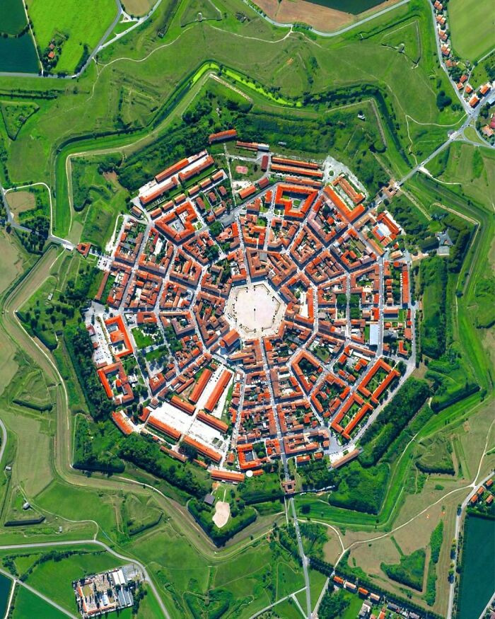
Image credits: worldurbanplanning
#3 Rennes, France
Rennes's history goes back more than 2,000 years. Rennes has grown incredibly since the 1950s, with its rural flight and the industrial development. During that time the city had great building plans to gain a population of 200,000 inhabitants. Today it has 700,000, and is the seventh biggest city in France. ⠀ ⠀ Here from a more rural development north of the city centre. A spiral development.⠀ ⠀
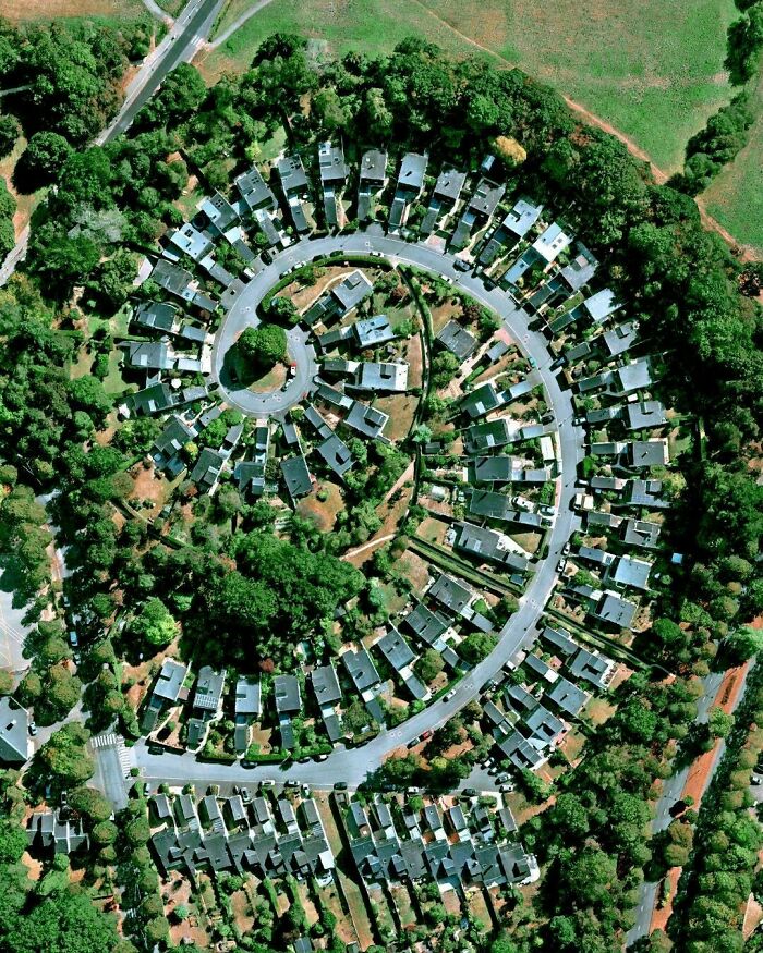
Image credits: worldurbanplanning
The World Urban Planning Instagram page has over 65,000 followers as of this posting. In addition to significant landmarks, it also features specific spots in each country, such as the Shanghai World Expo site, the BMW Tower in Munich, and this highway roundabout in the middle of the desert in the UAE.
#4 Brondby Garden City, Denmark
Brondby Garden City is located just a mere 15km west of Copenhagen. ⠀ Garden Cities have commonly been inspired by Ebenezer Howard’s Garden City concept; improving quality of urban life by establishing small peripheral garden cities around a central city. ⠀ ⠀ In 1964 the municipality of Brondby agreed to reserve an area for a "garden city". The architect wanted the gardens to be divided into circular shapes. He explained that the shape was to symbolise a historical village where people met at the well located in the center. By designing this way, the architect believed social interaction would increase between residents.
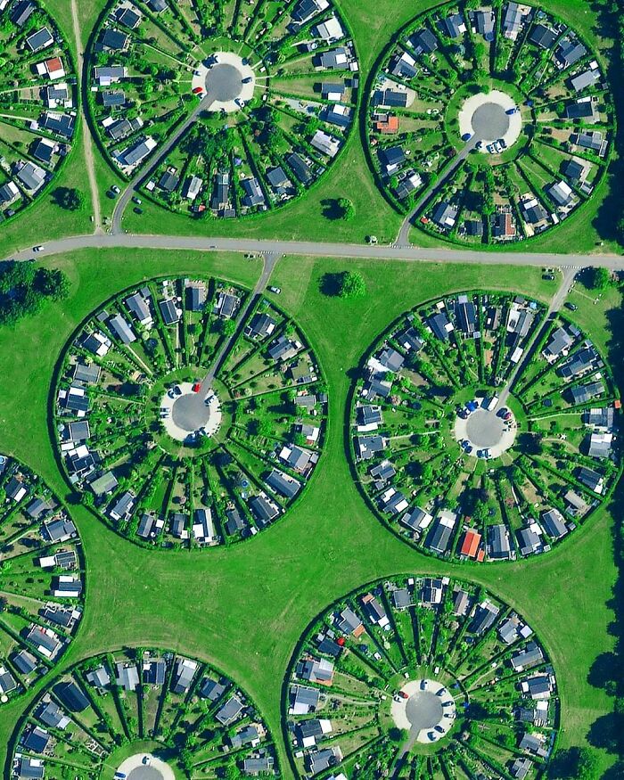
Image credits: worldurbanplanning
#5 Port Ariane, Lattes, France⠀
Port Ariane is a port located in Lattes. Lattes is a small commune with about 16.000 inhabitants. The city centre experience flooding once in a while so dykes and a spillway was built the past years. Fascinating circle-shaped marina area with a small park in the middle.
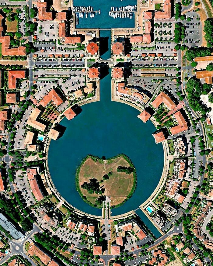
Image credits: worldurbanplanning
#6 Suloszowa, Poland
Suloszowa is a small village with almost 6,000 inhabitants, and has one of the longest streets in Poland (stretching 9 km non-stop) as shown in the image. Suloszowa is located just 29 kilometres northwest of Krakow, and is connected to famous attractions including Ojcowski National Park and Pieskowa Scala (14th century cliffside castle).
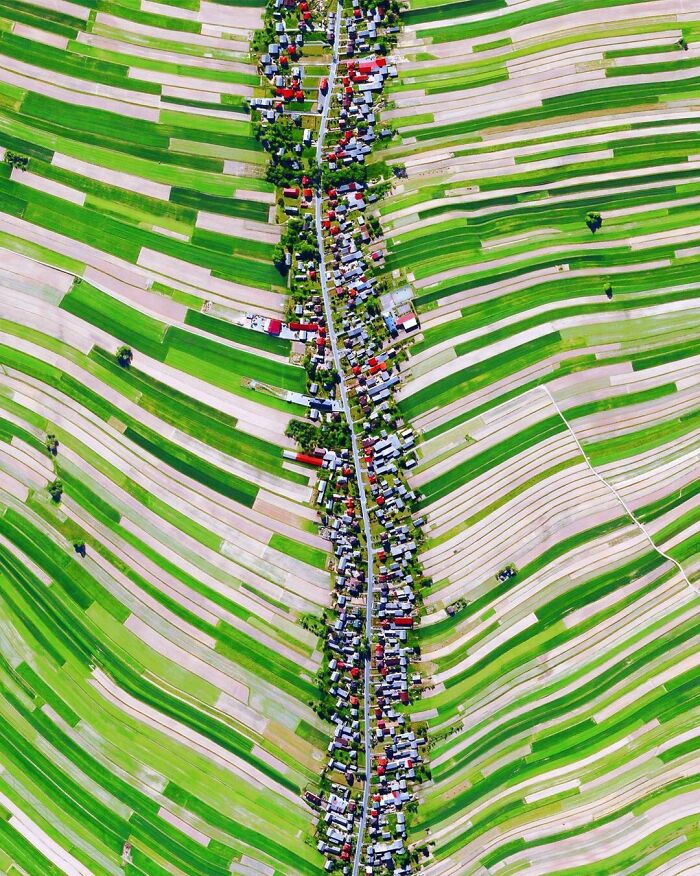
Image credits: worldurbanplanning
Singapore is one of the highlighted locations on the page. This island country/city-state is esteemed for its impeccable urban planning. Airline Cathay Pacific described it as “the best-planned city in the world.”
#7 Forte De Nossa Senhora Da Graça, Elvas, Portugal
The fort is located just north of the town Elvas bordering Spain. The town has some of the best preserved military architecture (star forts) and was designated as a UNESCO World Heritage Site in 2012. The fort, more commonly known as Forte Conde de Lippe (named after its designer Marshal Lippe), is approximately 150 metres quadrangle with pentagonal bastions in the corners. In the centre of the fort we find a decorated chapel. ⠀
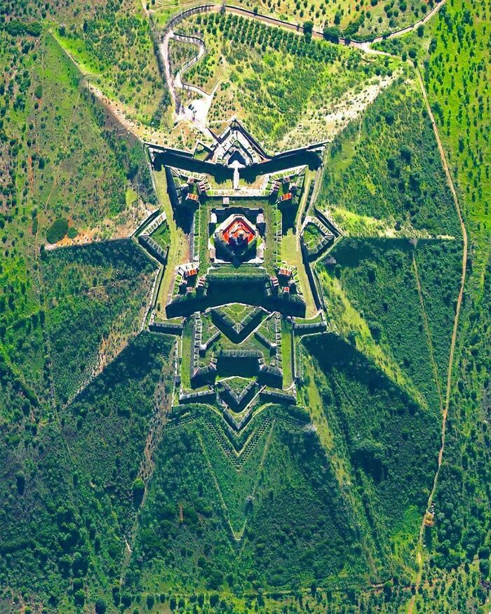
Image credits: worldurbanplanning
#8 Carnaxide, Lisbon, Portugal
In Portugal we can see how a more modern 60-70s suburban development has been built in the vicinity of the old city of Lisbon. The aerial view shows residential apartment buildings connected into a large residential complex. Carnaxide is a former third level administrative subdivision (civil parish) in the municipality Oeiras. It dates back to the 13th century when it became the first suburban parish of Lisbon.
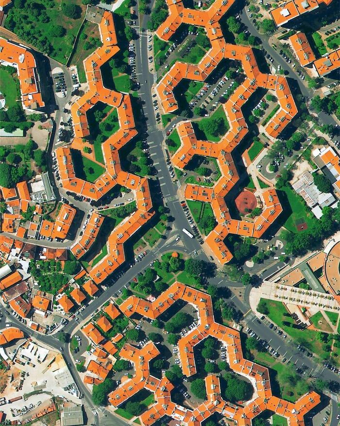
Image credits: worldurbanplanning
#9 Venice, Italy
Venice in Italy is archipelago of 117 islands formed by 177 canals in a shallow lagoon, and connected by 409 bridges. In the old centre, the canals serve the function of roads, and almost every form of transport is on water or on foot.
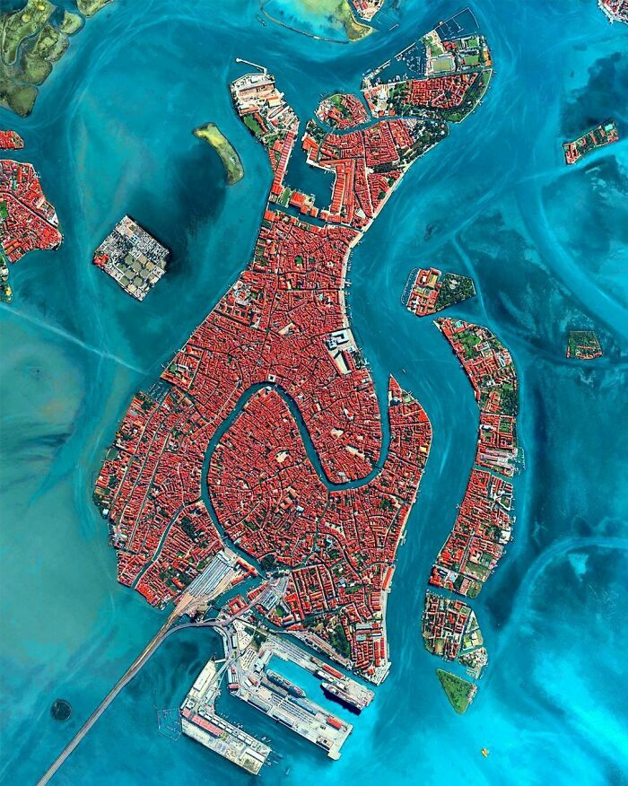
Image credits: worldurbanplanning
With a landmass size of 720 square kilometers (roughly 278 square miles), Singapore’s city planners had to be purposeful with their land use.
Dr. Liu Thai Ker is primarily credited with Singapore’s modern architecture. One of his insights focused on long-term planning.
#10 Plaza De Tetuán, Barcelona, Spain
The now famous, but at that time radical, urban planner Ildefons Cerdà designed the grid pattern in Barcelona named Eixample. The design has long straight streets, wide avenues, and octagonal square blocks with rounded corners placed in a strict grid pattern. This has given better visibility, air and is the grand aerial landmark of Barcelona.⠀
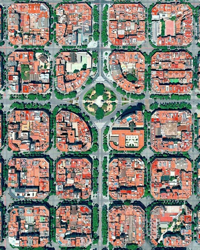
Image credits: worldurbanplanning
#11 Bern, Switzerland
Bern's old city was built on a narrow hill surrounded by the river Aare on three sides. The compact layout of the city has barely changed at all since its construction between the 12th and 15th century, and has kept its medieval character. In 1983 the old town was listed as a UNESCO World Heritage Site for its original medieval character. A great city where public transportation, biking and walking is a pleasure.
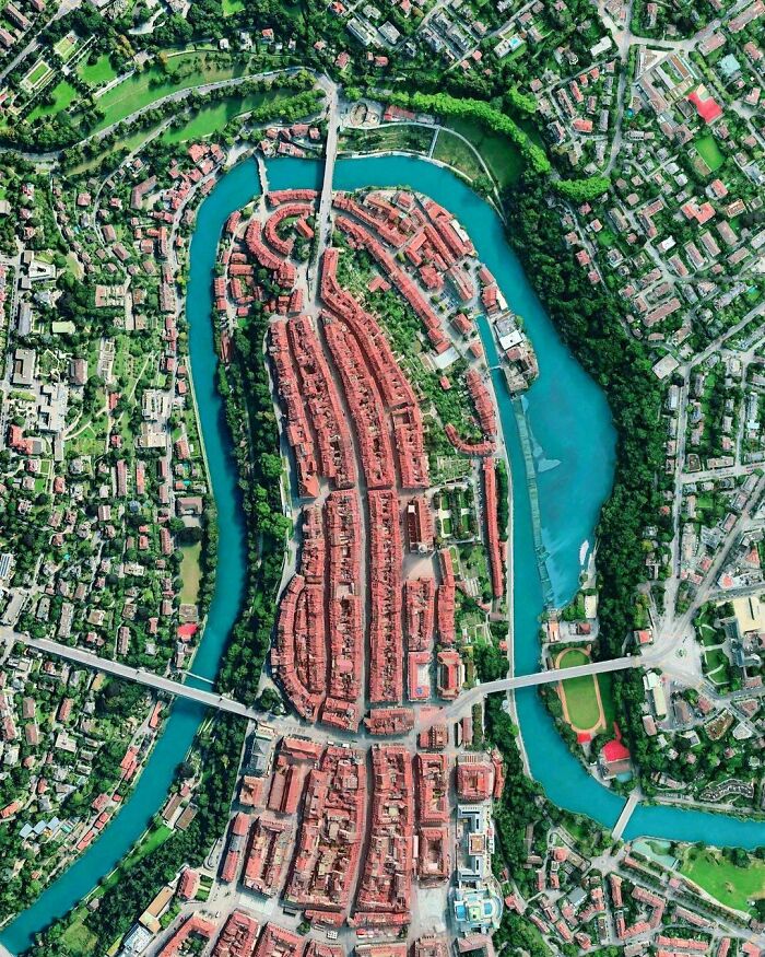
Image credits: worldurbanplanning
#12 Grammichelle, Sicily, Italy
Grammichelle was built in 1693, and was laid out with six roads circling around the central square where you find the Town Hall and Mother Church. The six roads later expanded to more roads. Today it is one of the many hexagonal baroque towns you can find in Sicily.

Image credits: worldurbanplanning
“In 1971, when we were still very poor, we already laid down the MRT lines on paper,” he said in a 2017 interview. “We had no money, and we went through a lot of debates on whether we should have the MRT or not.
“In 1982 when we had the money and decided to build the MRT, the lines were already there and the land had already been acquired.”
#13 Lombard Street, San Francisco, Ca, USA
Lombard Street is perhaps the most famous crooked street in the world with 2 million yearly visitors. It is a one-way block where eight sharp turns (total of 600 feet/180 meters) help reduce the steepness. It was built in 1922 to reduce the hill's natural steep 27% grade, which was far too steep for the most common cars.
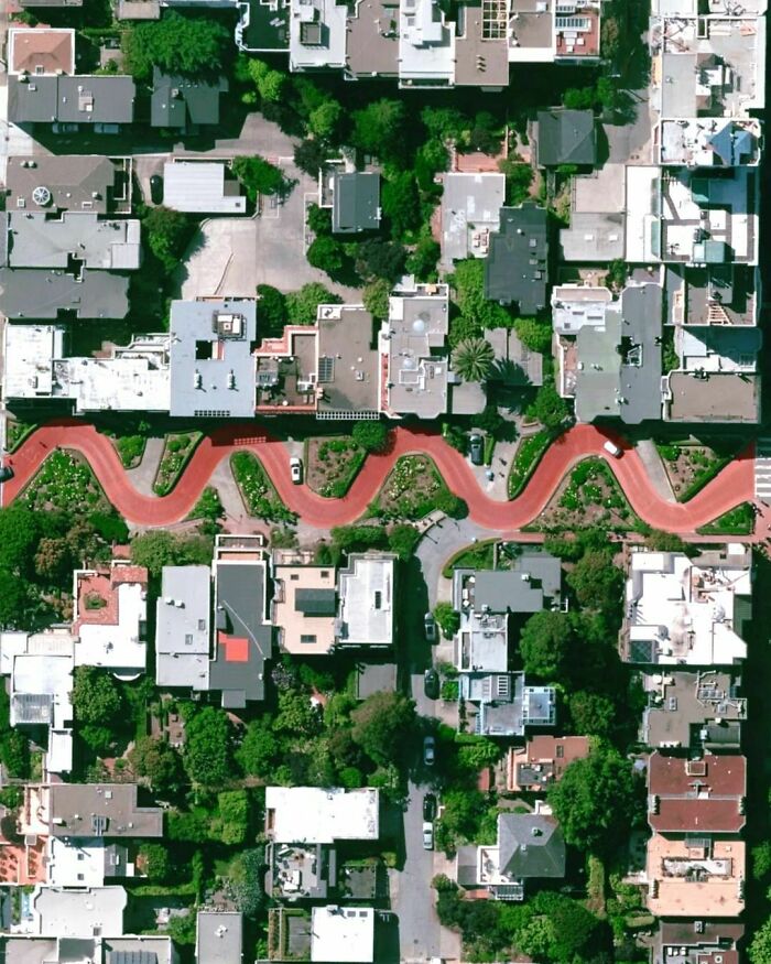
Image credits: worldurbanplanning
#14 Arc De Triomphe, Paris, France
The famous monument Arc de Triomphe is located in Paris. It honours the ones who fought and died in the Napoleonic wars and French revolution. It was designed by Jean Chalgrin, in 1806, who was inspired by the Roman Arch of Titus, and in 1836 the construction finished. It was the tallest triumphal arc with a height of 50 meter, but the Momento a la Revolución (67m) in Mexico and the Arch of Triumph (60m) in North Korea exceeded its height in 1938 and 1982 respectively.
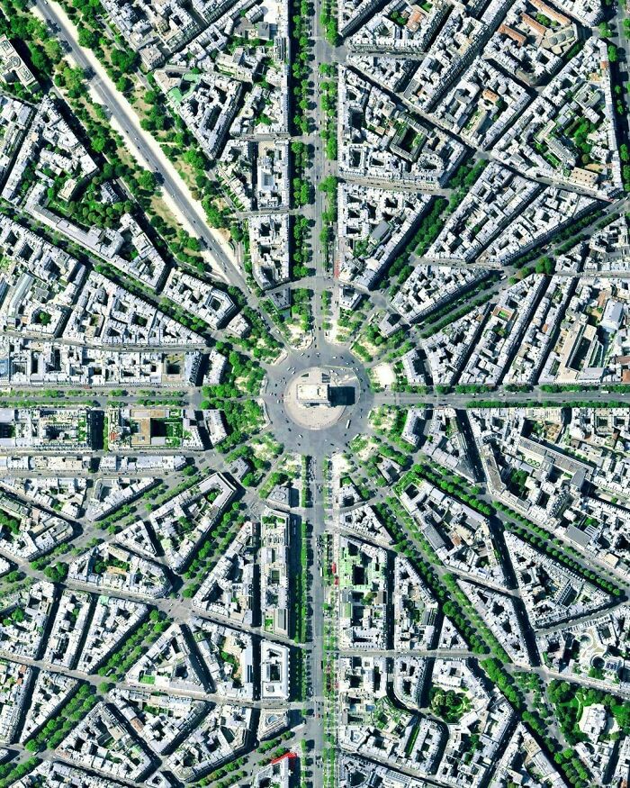
Image credits: worldurbanplanning
#15 Vicinity Of Port Said, Egypt
Port Said is a port city located north-eastern part of Egypt. It was founded in 1859 when the Suez Canal was developed. Within this area we find a number of canals along agricultural farm developments.
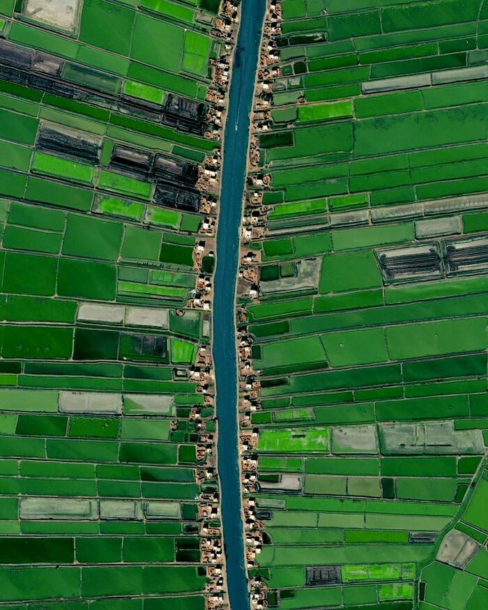
Image credits: worldurbanplanning
Urban planner Jason Satori spoke to National Geographic about studies linking city planning to obesity. In his work, he has focused more on public health.
“When we design cities in ways that require people to drive rather than walk, and when we design streets that make biking dangerous, we discourage people from engaging in physical activity."
#16 Central Park, New York, USA
Central Park opened to the public for the first time in 1858 as a 778 acre or 3sq.km park (later on expanded to 843 acres or 3.41sq.km). The park is approx. 4 km long and 1 km in width. To walk across the entire park it would take you approximately 45 minutes. Many think Central Park is one of the largest city parks in the USA, however even San Fransisco’s Golden Gate Park is 20% bigger in size.
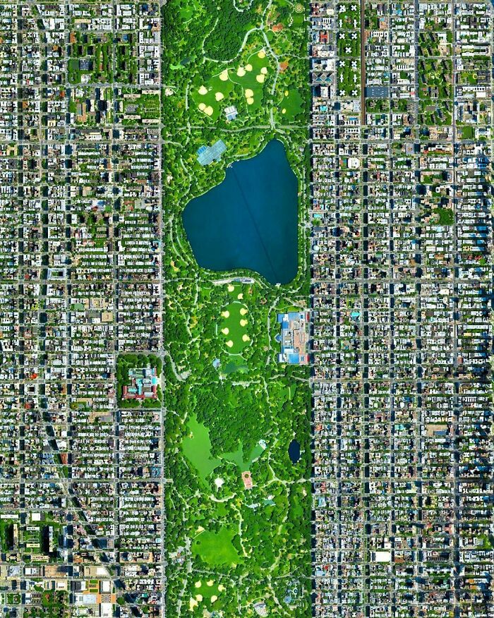
Image credits: worldurbanplanning
#17 Golden Gate Park, San Francisco, California, USA
Golden Gate Park is a huge 1,000 acre park. Back in the 1860s San Franciscans felt a need for a spacious park similar to NYC's Central Park which was at that time under construction. Golden Gate Park, established in the 1870s, is however 20 percent larger than NYC Central Park and has been stated as a masterpiece in landscape architecture.
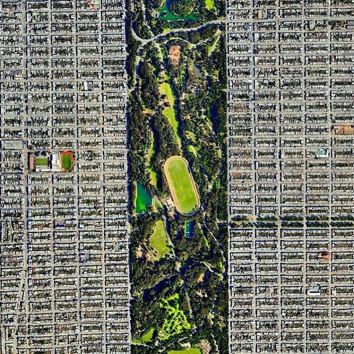
Image credits: worldurbanplanning
#18 Toledo, Toledo Province, Spain
Toledo used to be the capital of the Spanish Empire before the middle of the 16th century. It has an extensive cultural and monumental heritage, and has been ruled by different groups of Christians, Muslims and Jewish cultures. The streets in the Old Town are winding and cobbled and often filled with locals and tourists, as well as a great number of vehicles (which do somehow find their way through the city).
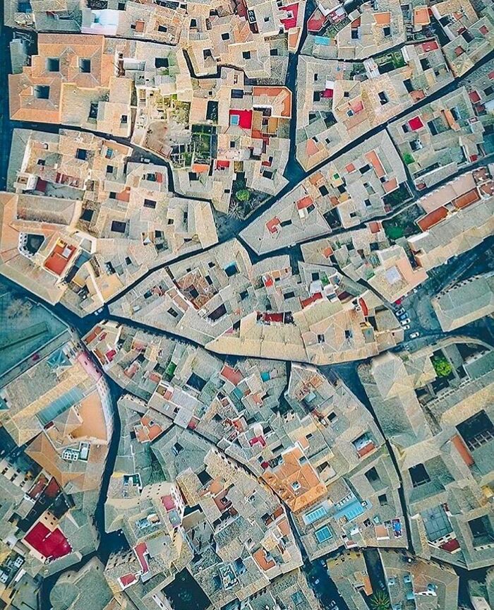
Image credits: worldurbanplanning
According to the same National Geographic article, many other countries have adopted the same philosophy through bike-friendly streets. Cities like Vienna, Munich, and Denmark are closing off streets to accommodate bikers and ensure their safety.
In the United States, the city of Chicago followed suit in 2023 by installing more than 50 lanes of bike-friendly routes. The government also added concrete barriers in streets with unprotected lanes to ensure safety.
#19 Runaway Bay, Queensland, Australia
Runaway Bay is a suburb on the Gold Coast in Queensland, Australia. In 1967, a company bought 182 hectares of land along the western shore of the Gold Coast Broadwater. Development of the area started in 1972 where they had the goal of transforming it into a residential and boating area. The name "Runaway Bay" was coined to promote the area as a tranquil retreat. As other Gold Coast suburbs, many of the homes in Runaway Bay are situated along artificial canals.
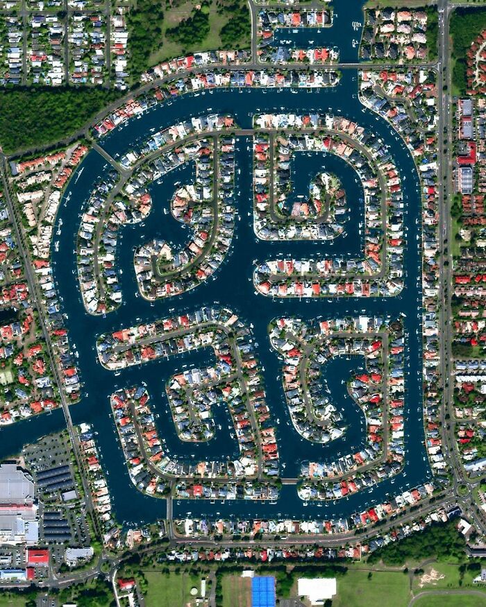
Image credits: worldurbanplanning
#20 Arvaikheer, Mongolia
Arvaikheer is town in Mongolia accommodating 30,000 residents. It is the capital of the Övörkhangai Province, and is located in the middle of Mongolia’s 1,5 million sqkm of land. Foremost, the town is known for its traditional art, animal husbandry and equestrian sports. Yearly regional horse festivals are held to celebrate its long history of famous racing horses (dating back to the 18th century). In Mongolia, we find Land use plans at three different levels; National, Provincial and Local. Firstly, the National Land Management Plan covers the entire country of Mongolia and reflect the strategic planning 20 years ahead. Its mission is to develop a plan that is reasonable in its use for development, sustainable conservation and protection of the country. It also shall ensure that it works towards enhanced living standards for its citizens and grow the national economy. ⠀ ⠀
Secondly, the Provincial and Capital City Land Use Plans covers the province with focus on the provincial capital. The plans are required to follow to the National Land Management Plan, and must reflect the environmental issues and matters relating to the protection of the land. This plan reflects the strategic planning 12 - 15 years ahead.⠀
Finally, the Sub-county Land Use Plans is a detailed plan dealing with the immediate land management and development matters within the sub-county. The plan is required to follow the National and the Provincial Plan, and is created every year.
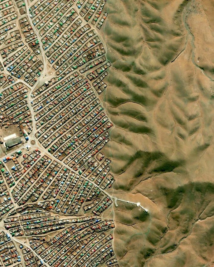
Image credits: worldurbanplanning
#21 Park La Brea, Los Angeles, USA
Park La Brea is a large housing complex located in LA. It has a total of 4,247 apartments divided into eighteen 13-floor tall towers and thirty one 2-floor tall garden townhouses, making it is the largest housing development west of Mississippi. The townhouses were designed in 1941, while the iconic X-shaped towers were designed in 1948, inspired by Le Corbusier with shared green space for the residents. In the photo we see a few of the X-shaped buildings and townhouses.
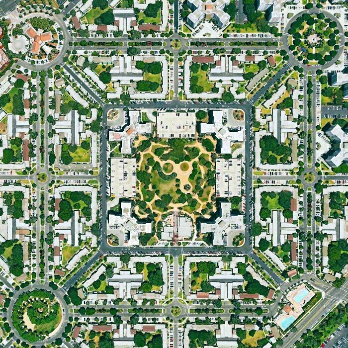
Image credits: worldurbanplanning
Joanna Trotter of the Metropolitan Planning Council also spoke with NatGeo about the dip in population in Gary, Indiana, due to poor city planning.
“Gary, Indiana, was originally planned for 200,000 people. The closest the city ever got to that number was in 1950 when it had 178,320 people. Today, Gary has 80,000 people—less than it did in 1930.”
#22 The Forbidden City, Beijing, China
The Forbidden City (紫禁城) was the Chinese imperial palace, which was the home of emporers and the political centre, from 1420 to 1912. It is located in the centre of Beijing and today houses the Palace Museum. Inside, the 180 acre palace ground, we find 980 buildings with a total of 8,886 rooms. Outside, it is surrounded by huge imperial gardens. The palace exemplifies traditional Chinese palatial architecture, and has influenced the cultural and architectural developments both in East Asia and globally. In 1987, the Forbidden City was declared a World Heritage Site and is listed by UNESCO as the world's largest collection of preserved ancient wooden structures.
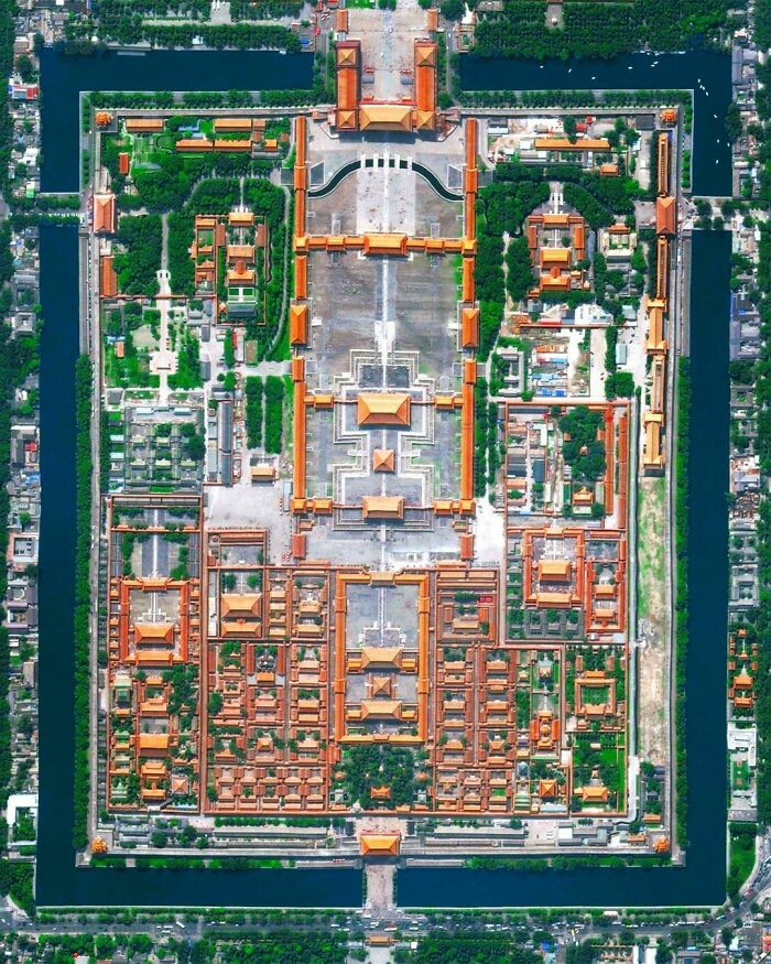
Image credits: worldurbanplanning
#23 Putrajaya, Malaysia
Did you know that the world's longest roundabout is located in Malaysia? The roundabout, completed in 1999, is 3.5 km long and a part of the planned city of Putrajaya. The city was established in 1995, freshly planned, and more than 35% of the total land area is reserved as open green space. ⠀ ⠀ The city is located 25 km south of Kuala Lumpur and serves as the administrative centre of Malaysia. The seat of government shifted in 1999 from Kuala Lumpur to Putrajaya, due to overcrowding and congestion in Kuala Lumpur. This is similar to what the government in South Korea did when they moved most governmental agencies and institutions to Sejong City. A stronger move was done in Myanmar when the capital status was moved from Yangon to Naypyidaw in 2005.
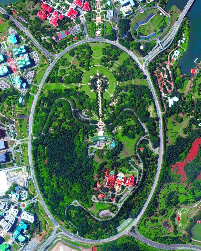
Image credits: worldurbanplanning
#24 Olivos, Buenos Aires, Argentina
Buenos Aires, founded 1536, is a city with a grid-pattern. Charles Darwin once describes the grid structure quite remarkably. He explained that Buenos Aires was "one of the most regular [cities] in the world. Every street is at right angles to the one it crosses, and the parallel ones being equidistant, the houses are collected into solid squares of equal dimensions, which are called quadras."
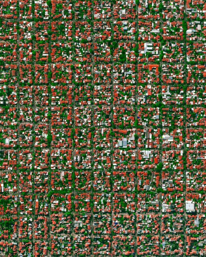
Image credits: worldurbanplanning
Regarding Gary’s future, Trotter is likewise focused on long-term growth. Her ultimate goal for the city is a potential industrial boom.
“Planning includes better housing and transportation, as well as parks and rivers that are clean and available for use by the public.
“We are preparing Gary not for growth, but for stabilization. We were working with the city to find projects that will attract businesses and strengthen the urban core.”
#25 Antigua, Fuerteventura, Spain
Antigua is one of the six Municipalities of Spain belonging to Canary Island Fuerteventura, and is one of the oldest municipality on the island. In the 19th century the town (also municipality) used to be the capital, but this title has been taken by Puerto del Rosario since. A windmill and some mansions are testimony to the former importance of the place. Particularly striking is the blue and white Art Nouveau villa from the period around 1900. This picture shows residential and resorts within the Fuerteventura, Castillo Caleta de Fuste located a few hundred meters from the sea.
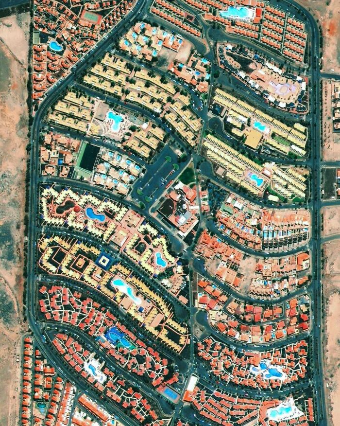
Image credits: worldurbanplanning
#26 Washington Dc, USA
Lincoln park established in 1867 is a park in the center of the urban Washington DC. Pierre L'Enfant, the French-American, behind the design of the streets in Washington DC, or known as the L'Enfant Plan, included Lincoln Park in the original plan of 1791. In L'Enfant's Plan, most streets would be part of a grid system. Some streets had an east-west direction, and others north-south direction. The diagonal avenues which intersected with the north-south and east-west streets in circles and rectangular plazas were later places where notable Americans were honoured and provides an open space for the general public.⠀ ⠀ In the top you can see the road leading up to the neoclassical white-styled Capitol Hill.

Image credits: worldurbanplanning
#27 Foster City, San Mateo, Ca, USA
Foster City is a planned city located in California. The city has been ranked as one of top towns to live well and best places to live by Forbes and Money magazine. Foster City was founded in the 1960s on a landfill in the marshes of the San Francisco Bay. When we compare the original 1961 Plan for Foster City to the city it is today, we see a plan which is well conceived and well implemented. The land area of the city is still the same, likewise with the configuration of the "Venice-like" Lagoon system which formed the backbone of the plan, the major roadway network, the land use configurations and major public facilities. Foster city is said to be a successful urban planning project which, already in 1958, pioneered many planning and urban design standards we value today in good placemaking and sustainability.
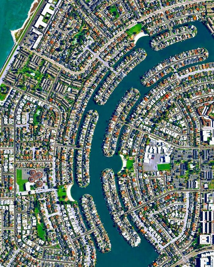
Image credits: worldurbanplanning
Other U.S. cities make it easier for their residents who prefer sustainable living. Chicago’s Sustainable Development Division provides aid and assistance for those who want to grow plants and fish in mini greenhouses called “hoop houses.”
Division head Kathy Dickhut recognizes the importance of these structures, especially when growing crops under the city’s weather pattern.
“In hoop houses, crops like kale can be grown 10 months out of the year, even in a Chicago climate.”
#28 Wemding, Bavaria, Germany
Wemding is a town and municipality with about 6000 inhabitants. The town is perhaps most known for the Zeitpyramide, a public artwork started in the early 90s and is scheduled completed in the year 3183. However, the historic town center is worth mentioning for having been declared a historic monument and was kept protected thanks to the circular town walls we see in this image. In the middle we see a marketplace together with the middle-class houses. The town has been referred to as the town of the fuchsias as the botanist Dr. Leonhart Fuchs was born and raised here. Therefore every year for two days the marketplace is filled with plants and scents, and a fuchsias pyramid is built with 1.000 fuchsias. This year the event was cancelled due to COVID-19, but will take place 29th – 30th May 2021. Quite a spectacular sight if you happen to be in the area.
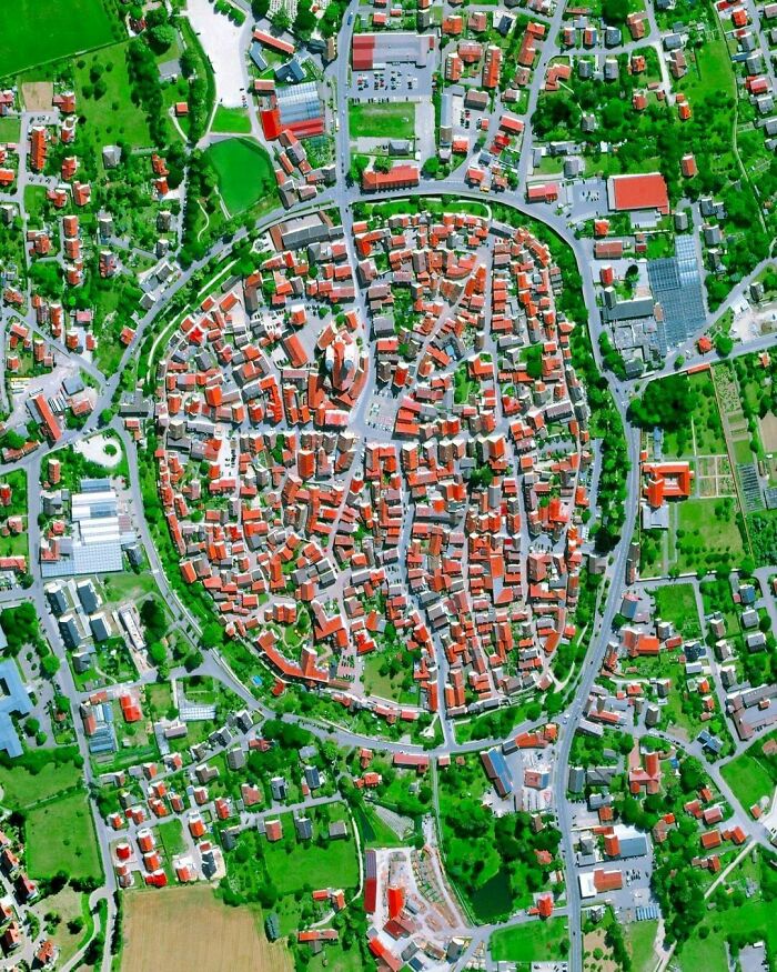
Image credits: worldurbanplanning
#29 Elche, Alicante, Spain
Today we are sharing one of our favourite photos. Elche is one of the 20 largest cities in Spain. It is the successor of La Alcudia which Greeks, Carthaginians and Romans had in possession at a time. Elche lost its some of its importance when it was moved from the sea, but became important for its traditional footwear industry when the railway was introduced. The "Palmeral of Elche" is an UNESCO World Heritage for its over 200.000 palm trees.
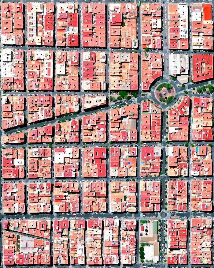
Image credits: worldurbanplanning
#30 Sun Lakes, Arizona, USA
Sun Lakes is a master-planned community developed around the mid 70s by a single builder, Robson Communities. The Sun Lakes Resort was created for retired citizens to provide excellent and relaxing surroundings. In the area you find 10,000 homes, five golf courses, five country clubs, two shopping centers and a medical and education center.

Image credits: worldurbanplanning