Nearly 45 million Americans are under winter weather alerts and warnings from North Carolina to northeastern Maine, as a major winter storm threatens the region.
Why it matters: It is predicted to be the biggest blizzard since 2018 to strike the Northeast with more than 2 feet of snow possible in parts of eastern Massachusetts, according to the National Weather Service.
Here is another way of looking a the potential snowfall for the this weekend's storm. pic.twitter.com/dqlevk5UxF
— NWS Eastern Region (@NWSEastern) January 28, 2022
State of play: New York Gov. Kathy Hochul directed state agencies to prepare their emergency response, while Virginia Gov. Glenn Youngkin declared a state of emergency Thursday in anticipation of the possible blizzard set to begin Friday.
- "We are very concerned with the forecasted impacts to our Eastern Shore region and have started pre-positioning resources to ensure a timely response to that area," Youngkin said.
The big picture: The bomb cyclone is expected to begin during the day Friday along the East Coast. The forecast has had a high degree of uncertainty, especially for the Philadelphia and New York City metro areas, but it's clear that a powerful storm was building along the East Coast.
- "Numerous hazards are likely from heavy snow, with significant accumulations across eastern Long Island/New England, to gusty winds and coastal issues," the NWS said on Friday morning.
- At the height of the storm on Saturday, snowfall rates in eastern Massachusetts could exceed 3 or even 4 inches per hour, per the NWS. Blizzard conditions are expected due to the combination of heavy snow and strong winds for areas from eastern Long Island through coastal New England.
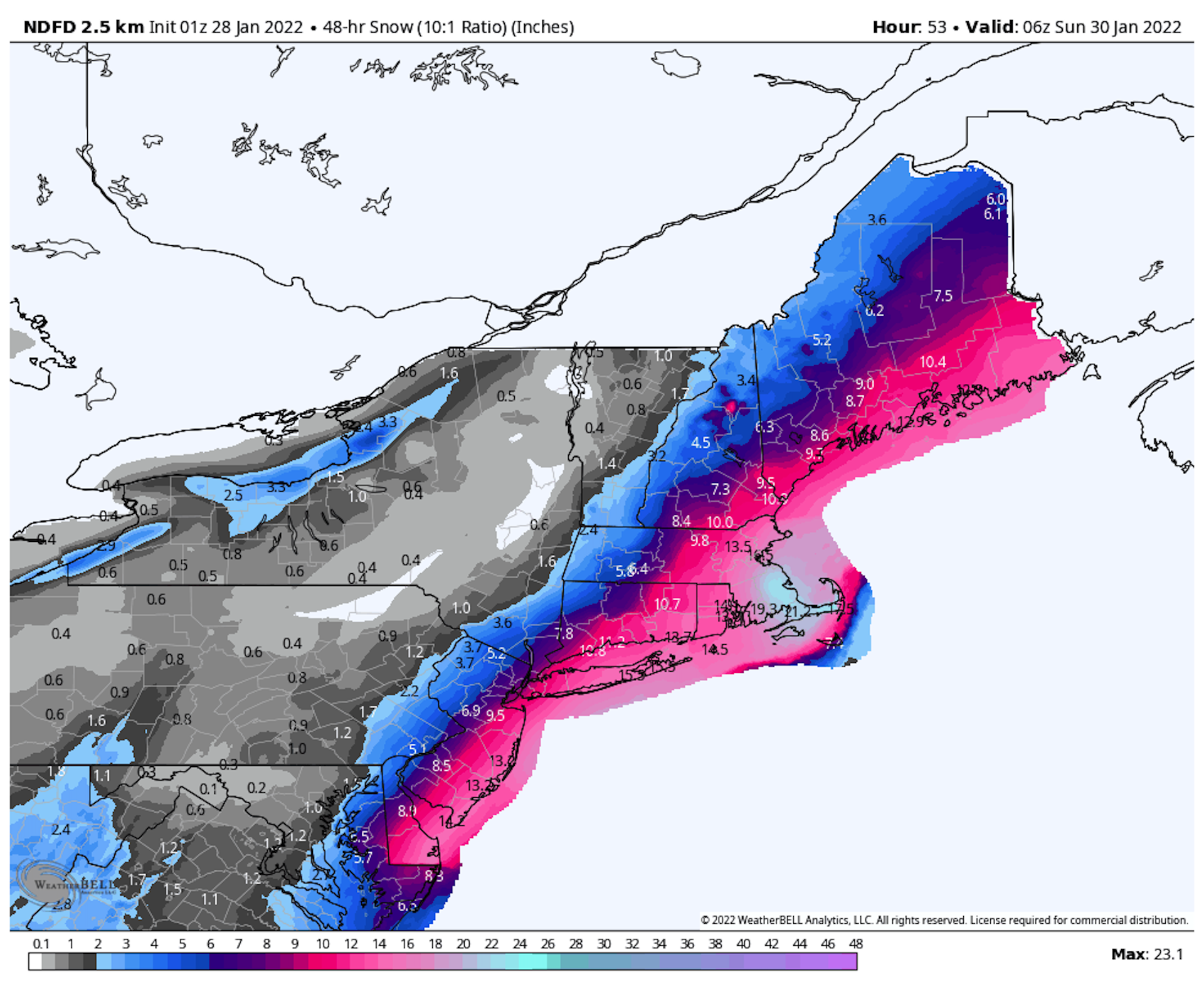
What else to watch: The snowfall totals for New York City and Philadelphia are the most uncertain, though snowfall is expected to end by early afternoon on Saturday across these regions.
- Nor'easters like this one, which feature strong winds blowing from the sea towards the shore, are able to "inflict even more flood damage than they used to just a few decades ago" as sea levels rise.
- "There remains some uncertainty with the exact storm track which will have a direct impact on accumulations and where the heaviest snowfall sets up," a forecast discussion from the NWS Boston office reads.
- "In addition, we are increasingly concerned about blizzard or near-blizzard conditions developing."
Axios Climate/Energy reporter Andrew Freedman contributed reporting.
Editor's note: This article has been updated with details of Hochul's response and further comment from the NWS.